UPDATE: Check out ten reasons TopoFusion rocks.
Today we’re going to look at programs that download maps from TerraServer, a partnership between Microsoft and USGS. With these applications, you can view topo maps and aerial photos, and even detailed color imagery for urban areas.
My favorite application in this category is TopoFusion, which has a long list of advantages. Here are a few of them:
- A free demo mode. The full version is $40 and well worth it.
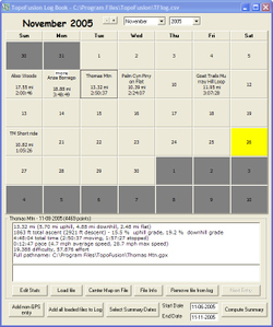
- A log book that captures a history of your trips in calendar format.
- Ability to switch between topos and aerial photos of a location, or blend the two.
- 3-D views.
- PhotoFusion automatically links photos to where they were shot.

As I said in my last post, all software has its drawbacks. Two key ones for TopoFusion are its limited route creation tools and poor printing support. The latter is a common deficiency with programs in this category. And all TerraServer topos are a little less sharp than those found in CD-based programs.
Lets look at a few screenshots.
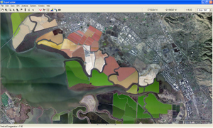
At left is a 16 meter/pixel color urban image of the salt ponds in the southern end of San Francisco Bay.

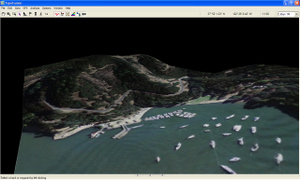
At right is a 3-D image of Angel Island. Further down the page on the left is the Log Book feature I referenced earlier.
Some other programs that utilize TerraServer imagery (neither have 3-D capability):
- USAPhotoMaps is a wonderful free program, though it lacks many of the features I find so useful in TopoFusion.
- ExpertGPS takes a different approach than TopoFusion, putting maps and aerial photos side-by-side.
There are full chapters on TopoFusion, ExpertGPS and USAPhotoMaps in my book, GPS Mapping – Make Your Own Maps.

Other posts in this series:
- * Choosing the best mapping software: Introduction
- * CD-based mapping software: National Geographic TOPO!
- * Software for power mappers: OziExplorer
- * Free topos and aerial photos: USAPhotoMaps
- * Free waypoint manager: EasyGPS
- * Converting GPS file formats
