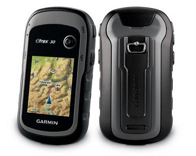
The Garmin eTrex 30 is the top of the line model in the new eTrex series, which brings a long-awaited update to this popular line. It offers paperless geocaching, new customization options and BirdsEye aerial imagery capability.
I’ll get into all the details in a moment, but first let’s look at what separates the eTrex 30 from the other models in the series…
Related units
- Drop down to the eTrex 20 and you’ll lose the 30’s tri-axial electronic compass, barometric altimeter, wireless data sharing and Garmin chirp compatibility
- The entry level eTrex 10 has a monochrome screen and no ability to add maps
- To see how the eTrex 30 stacks up against other models, check out my Garmin handheld GPS comparison chart
NOTE: Much of the following is adapted from my hands on review of the eTrex 20.
Garmin eTrex 30 hardware
Buttons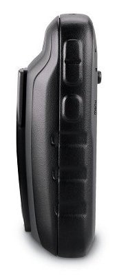
There are six buttons on the eTrex, three on the left, two on the right and one on the front (see image at top of page):
- Zoom in and zoom out buttons – These are on the left and can also be used to navigate menu lists a page at a time
- Menu button – (Also on the left side) Brings up a context sensitive menu; double-tap to access the main menu; press and hold to bring up the Find menu
- Back – On the right side; moves you back a step in the menu structure
- Power/Light – (Also on the right side) A short tap brings brings up a screen with date/time, battery and GPS status; additional short taps toggle between 0, 50 and 100% backlight; press and hold to power down
- Thumb stick – Located on the front of the device, you can toggle it side to side or up and down to navigate menus and pan the map; press down to enter a menu command or select a map point; press and hold to mark a waypoint
Display
The eTrex 30 has a bright but small display that is easily visible in sunlight or with the backlight engaged.
Garmin eTrex 30 interface
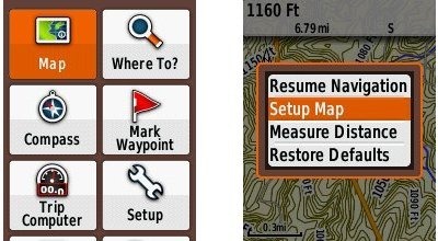
When you power up the eTrex 30, you’re taken to the Main Menu (below at left). You can change the order of items by pressing the menu button. If you select another screen (e.g., map) and then press the menu button, you’ll find a context-sensitive menu (shown below at right).
Garmin eTrex 30 features
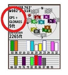 GLONASS
The one item found on the new eTrex series missing from all other Garmin units is the ability to use GLONASS as well as GPS satellites. There is an option to use GPS only, but no option for GLONASS only. Theoretically, GLONASS will improve accuracy. This may be especially true at northerly latitudes and in urban (and natural) canyons. I’ll talk about this a bit more in the performance section of this review.
More new features for the eTrex series
Many of the features found on higher-end Garmin handhelds are now available on the eTrex 30. These include…
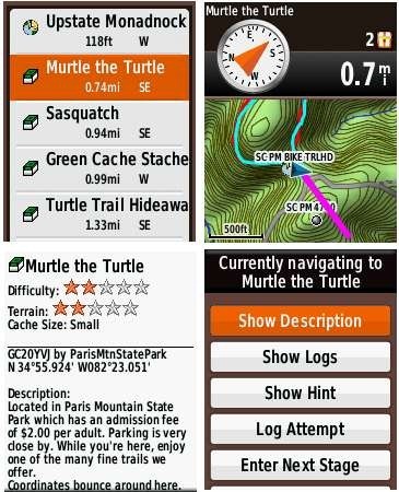
Paperless geocaching
This gives you the ability to view description, hints, log, etc., in the field. The eTrex 30 also allows you to filter caches, letting you search by size, difficulty, terrain, etc. I’ll have more to say about geocaching in the performance section of this review. Some screenshots:
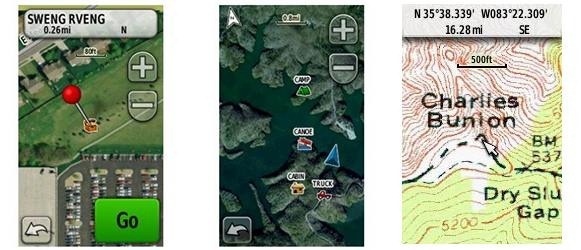
BirdsEye aerial imagery and topo maps
The eTrex 30 is fully compatible with Garmin’s BirdsEye products, including their aerial imagery and topo maps of the US and Canada. Each runs $30 for a one-year subscription; imagery you’ve downloaded during that period can still be used, even if you don’t renew. While the images below weren’t captured on an eTrex, they should give you an idea of the capabilities…
BirdsEye aerial imagery is particularly useful for urban cachers, outdoors lovers in the open landscapes of the American west, and for boaters. I find it less useful under the dense canopy of the eastern US.
I absolutely love the BirdsEye topo product. There is nothing quite like having the map on your device look exactly like the USGS topo in your hand.
Advanced track navigation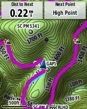
I have written before about advanced track navigation, but basically it will give you the best of both worlds when it comes to following a track or route. Simply choose a track to navigate and it will construct a route of waypoints along the track, add in high and low points, and give you the actual track mileage to each point, as shown at left.
Garmin custom maps
Now that we have BirdsEye Topo, there isn’t as much need for custom maps, but hey, you can put a PDF park map on your eTrex, and that’s pretty sweet.
Calendar
The Calendar displays dates when waypoints and tracks are saved, and it also displays geocaches that you’ve logged.
Profiles
Profiles allow you to save different groups of settings; you can have one for geocaching, one for mountain biking, one for road riding, etc. These are discussed more below under “Customizing the Garmin eTrex 30.”
More eTrex 30 features of note
Route, Track and Waypoint management
The eTrex 30 has excellent route, track and waypoint management tools, including:
- Waypoints – The ability to project a waypoint, average location, set proximity alerts, and to reposition a waypoint at your current location
- Tracks – You can choose to hide or show multiple tracks on the map, view an elevation plot, and give them a custom color (17 colors are available); the color of the active track may also be changed
- Routes – You can view a map of the entire route, edit the route, reverse it and view an elevation plot
Ability to add free maps
One of the great things about Garmin handhelds is the ability to add free maps to them, and the eTrex 30 is no exception. GPS File Depot is an excellent source of maps for the eTrex.
Customizing the Garmin eTrex 30
Main menu item order – You can customize the main menu item order by pressing the Menu button while viewing the Main Menu.
Accessing pages via the back button – Use Setup > Page sequence for this, but be aware that these pages will disappear from the main menu.
Profiles – The eTrex 30 comes with recreational, geocaching, automotive, marine and fitness profiles. You can switch profiles by selecting Profile Change from the Main Menu. Or create a new one by going to Main Menu > Setup > Profiles > Create Profile. Select the new profile to edit the name. Any changes you make in menus or other settings will be retained in that profile. So start changing things! Want track up when geocaching and north up when biking? No problem. How about a separate profile that just shows USGS topos or aerial imagery? The possibilities are nearly endless.
Data fields – You can change data fields on just about any screen that has these; usually you just press Menu > Change Data Fields.
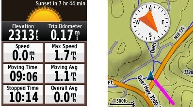
Dashboards – Instead of data fields (and in some cases in addition to), you can select a dashboard for the map, compass and trip computer screens. Choices (depending upon page) may include automotive, stopwatch, small or large data field, recreational, compass, geocaching or elevation plot. I’ve included screenshots showing a couple below. For the trip computer and compass pages, you access this via Menu > Change Dashboard. For the map screen, choose Menu > Setup Map > Data Fields > Dashboard. The one downside here is the small screen on the eTrex series; using a dashboard can significantly reduce map real estate.
Unique to the eTrex 30
Let’s go over the features found on the eTrex 30, but not on the 20:
- Triaxial electronic compass – Having an electronic compass means the eTrex 30 can point to your destination while standing still; triaxial means you don’t have to hold it level like other electronic compass models; the downside is that you will have to calibrate the compass after each battery change
- Barometric altimeter – This will give you more accurate elevation readings and allow you to see an elevation plot of your tracks
- Wireless data sharing – The eTrex 30 is capable of wireless data transfer with other compatible Garmin units; you can transfer waypoints, tracks, routes and paperless geocache details
- Garmin chirp compatibility – Adds a new dimension to geocaching
Garmin eTrex 30 tips
I imagine there are more, but here’s a few tips:
- Use the zoom buttons to jump a full page in a menu
- When entering a name, the zoom buttons will switch between keypads
- You can create a custom startup message (e.g., if found, please call…) by connecting it to your computer and editing the Garmin/startup.txt file
- You can check the battery level by briefly pressing the power button; you may also dedicate a data field to battery status.
Garmin eTrex x0 series performance
The following refers to tests done on the eTrex 20:
Battery life
With the eTrex set to record a track point every five seconds, I left the device on, sitting stationary, under light canopy, powered by a fully charged set of Eneloop NiMH rechargeable AA batteries. With the backlight set to remain on full, batteries lasted 10 hours and 17 minutes. The backlight off test is still running, but I wanted to go ahead and post this. I’ll update that info later today. UPDATE: With the backlight off, the eTrex 20 ran for an amazing 23 hours and 29 minutes before shutting off.
Tracks
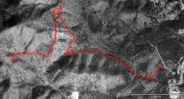
Tracklog accuracy was tested with the eTrex 20, GPSMAP 60CSx (with SiRFstar III chipset) and a GPSMAP 62s mounted on the handlebars of my mountain bike. All units were set to record track points every five seconds. Tracks were collected on out and back runs and then analyzed for track separation errors. The idea here is that, ideally, the track recorded on the way out should match perfectly with the one recorded on the way back to the trailhead. Of course no unit ever meets the ideal.
The 60CSx performed best, with less errors in general and a maximum track separation error of about 80’. The 62s had significantly more segments with easily visible track separation errors, maxing out at around 120’. The eTrex was worst, with more visible errors that tended to be separated by a greater distance, maxing out at around 125’. I find it interesting, but not surprising, that the oldest unit with the most mature firmware performed best, while the newest unit with the least mature firmware performed worst. Here’s an image of an eTrex 20 track (you should be able to click on it for a larger image)…
It gets more interesting when you look at the geocaching test results…
Geocaching
Caveat: I’ve yet to come up with a good way to test geocaching accuracy. There are just too many variables – accuracy of the cache coordinates, satellite constellation variability, terrain (multipath effects), etc.
So having said that, here’s a very unscientific test. After becoming familiar with the unit, towards the end of my testing, I made some cache runs. I set the units down on top of the cache one at a time and recorded the reported distance to cache in feet. The results are shown below.
GPSMAP 62s Oregon 450 eTrex 20 with GPS+GLONASS eTrex 20 with GPS only Cache 1 6 14 16 6+ Cache 2 20 49 10+ 15 Cache 3 36 29 13 48 Cache 4 30 37 26+ 44 Average 23 32.25 16.25 28.25 Not bad, and you can see that GLONASS appears to result in some improvement. The plus signs indicate cycling, where the distance to cache would cycle from a low number to a higher number over a period of a minute or so and then repeat. In this situation, I used the lower number in the charts above. The eTrex 20 seems to suffer from the malady that affects all new Garmins, where the firmware is far from perfect. This cycling was also seen in early firmware versions of the GPSMAP 62 and Oregon series.
Lags and redraws
I noticed some slight lags when navigating menus, and a bit of a delay (a second or so) on map redraws when panning the map. I noticed no map redraw delays while mountain biking with the unit though. Some users have reported map redraw delays with raster imagery such as Garmin’s BirdsEye products, though I believe these reports have been limited to map panning and not delays on the moving map.
Garmin eTrex 30 pros
- Bright display
- Small size
- GLONASS for improved accuracy
- Paperless geocaching capability
- BirdsEye aerial imagery and US/Canada topo compatibility
- Advanced track navigation
- Garmin custom maps capability
- Customization options (dashboards, profiles, etc.)
- Excellent battery life
- Triaxial electronic compass
- Barometric altimeter
- Wireless data sharing
Garmin eTrex 30 cons
- Small display
- Distance to destination cycling and tracklog separation point to immature firmware
Garmin eTrex 30 conclusion
Despite some early bugs, I like the new eTrex series, and think it will be a good unit for all sorts of outdoors lovers. My quibbles with it are pretty minor, and Garmin has a good track record of fixing significant issues (although it can often take awhile). The track separation issues aren’t bad enough to cause most folks navigation problems, though the distance to destination cycling could prove frustrating to geocachers. The extensive feature set, including paperless geocaching, GLONASS support and BirdsEye aerial imagery capability, is very nice. The eTrex series is lightweight and has extraordinary battery life, making it an especially choice for backpackers.
More Garmin eTrex 30 reviews
- Consumer-authored Garmin eTrex 30 reviews
have been posted at Amazon
- TakeAdventure.com has posted a first looks review of the eTrex 30
- An in-depth eTrex 30 review has been posted at GPS Information
I’ll be posting more hands on GPS reviews as they appear, but in the meantime, here are some…
Other Garmin eTrex 30 resources
- The Garmin eTrex 30 owners manual
- To see how the eTrex 30 compares to other models, check out my Garmin handheld GPS comparison chart or use Garmin’s own comparison tool
- The official Garmin eTrex 30 web page
Compare prices on the Garmin eTrex 30 at these merchants:
- Check the current Garmin eTrex 30 Worldwide Handheld GPS Navigator
price at Amazon
- Find the Garmin eTrex 30 GPS
at REI.com, where satisfaction is guaranteed and members get 10% back on eligible purchases
- Get the Garmin eTrex 30 from GPS City
- Buy the eTrex® 30
direct from Garmin
- Find the eTrex®30 Handheld GPS
at Abes of Maine
- Get the eTrex 30 from GanderMountain.com
- BassPro.com also carries the Garmin eTrex 30 Handheld GPS Unit – Outdoor Electronics
- Or you can buy the Garmin eTrex 30 from Cabelas.com


Hi
I’m trying to download waypoints.
It says “can’t get/create datasource”.
I can see coordinates on the gps but i can’t download it.
I use DNR GPS for download.
Any help?
Regards