Sunday, March 18, 2012

EarthTools – Contours in Google Maps

Earthtools

I’ve posted a multiple times about various ways to  view contour lines in Google Maps and Google Earth. Now comes EarthTools, a new Google Maps mashup that adds a contour overlay (see image at left). Various parts of the world can be seen at different zoom levels, with more detail and coverage being added over time. Unlike some other mashups attempting this, the contour data in EarthTools loads fast. Right now it only works in FireFox and the IE7 beta. Via Google Maps Mania.


Yahoo Maps adds satellite imagery

Yahoo Maps Beta has added satellite imagery to its site. This has been pretty well covered elsewhere today, so I’ll just provide a couple of links (Cartography and O’Reilly). Compare your favorite coordinates on Google Maps and see which you think is best.

Technorati tags: GPS

Topo maps on Google Maps

Two websites integrating topo maps with Google Maps recently came to my attention. The first is Topographs.com, which I discovered via Groundspeak. The other is BackcountryMaps.com, found via Google Maps Mania. I haven’t had a lot of time to explore these, but these are my initial impressions:

Topographs allows you to add GPS tracks, though not directly. But it is SLOW. At least it is on my computer. BackcountryMaps is faster, but there appears to be no GPS interface.

Related posts:

Technorati tags: GPS, Google Maps, topo

Convert Google Maps data to GPS waypoints

Josh at Communications from Elsewhere has updated his GMapToGPX bookmarklet, that allows you to convert Google Maps search results to GPX waypoints for your GPS. More information can be found in my previous post on this. As Josh opines, it’s difficult to keep up with changes to the Google Maps API, so it may break again. Crank out those waypoint files while you can.

Topograhic maps in Google Earth

Finally! You can now easily view topo maps in Google Earth, courtesy of the Global Biodiversity Information Council. And not just for the U.S.; Canada, Australia and New Zealand are also included. Be sure you note the listed caveats:

The topographic map layers provide increasingly detailed information as the Google Earth client is zoomed in. It is best not to activate the layers until the client is zoomed close to the area of interest.

  • Some topographic layers will spawn an error when zoomed too far out.
  • Similarily some topographic layers will spawn an error when zoomed too far in.
  • Occasionally errors will occur if the remote server takes too long to respond.
  • It is best to turn off the topographic layers when closing down Google Earth. This will prevent errors being reported when Google Earth is restarted.

Now it’s not the smoothest or clearest way to view topos, but it’s a start. These tools will only get better.

Many, many thanks to Stefan at Ogle Earth for finding this one.

Technorati tags: Google Earth, maps, topo

U.S. High Points

Us_high_points

Here is a nice Google Maps "mashup" for you outdoor enthusiasts — the U.S. Highpoint Explorer. It allows you to view the highest point in each of the 50 states, and it also allows you to view county high points within a state. There is even a regional view that shows the high points in the current view. A sidebar gives the key stats — name, elevation and rank. Pretty cool tool for you peak baggers! Via

My Favorite GPS Mapping Software

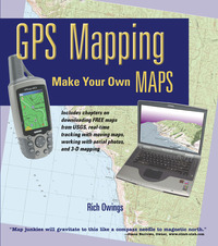
Frontcvr_webBecause I compared so many different software packages in my book, GPS Mapping – Make Your Own Maps (cover at right), I’m often asked what programs I like. In the book, I shied away from recommendations, focusing instead upon the pros and cons of each program, because no software is perfect. People who really get into this will often use multiple packages (a number of them are free or have extensive demo modes). Today, I’m going to take a different approach and share my favorites in each of several major categories.

CD-based maps

Here we’re talking about programs that package all the USGS topo quads for an entire state or region onto a DVD or set of CD’s, products like DeLorme 3-D TopoQuads and Maptech Terrain Navigator. These packages are ideal for producing printed maps. No other category can beat them for this. My current favorite though, is National Geographic TOPO! It’s not perfect, but in my mind, it has fewer drawbacks than the other two. One caveat though–these programs are constantly being upgraded. For example, I haven’t had a chance to check out the recently released Terrain Navigator 7.0, but I’m expecting a copy soon and will report back here with a full review.

Internet-based maps

read more

Online Sources of GPS Waypoints and Tracks

Some weeks ago I posted about downloading GPS tracks from MotionBased.com for trip planning. For a long time now, I’ve been wanting to post other online sources of GPS data. Lets say you’re planning a trip somewhere. Hiking, biking, fishing–it doesn’t matter. Wouldn’t it be nice to get waypoints and tracks from other GPS enthusiasts?

Some mapping software companies allow users to exchange data. Three notable examples are:

The first two are proprietary formats, which can limit their usefulness unless you have that product. The National Geographic TOPO format turns up a lot on websites devoted to outdoor adventure.

MotionBased uses the open standard .gpx format, which is being embraced by more and more software manufacturers over time. An extensive list of online sources of .gpx data is available from TopoGrafix, the developer of EasyGPS and ExpertGPS. This list encompasses everything from dive spots to UK hiking trails. Travel by GPS, one of the sources on the list has a page posted on data I contributed–my Mt. Diablo circumnavigation. I haven’t tried every source on the list, but GPXchange and TrailRegistry look particularly interesting.

There are plenty of other sources out there too. There is even a Yahoo GPS Tracks & Waypoints group devoted to data exchange. It’s always a good idea to search on Google for (insert park name, etc.) and waypoints or GPX. And there are a blue million hiking, biking, kayaking, hunting, fishing, etc., discussion groups out there. Many message boards have regional sections. There are typically some tech-type gear heads there who can help you out with online sources or even their own data.

Winter is a great time for planning next year’s adventures, and I hope these tools help!

Added 04.22.06 – GPS-Tour.info


Downloading GPS tracks from MotionBased.com for trip planning

As promised in last week’s review of MotionBased software, I’m going to show you how to use their site to download tracks for trip planning. Recently, I was trying to find a good map for Annadel State Park, a little slice of mountain biking heaven in Santa Rosa, California. My wife and I used to ride there all the time before we were married, when she lived within a stone’s throw of the park. About the time I lured her away, there was a massive reconfiguration of the trail system.
An opportunity came up to ride Annadel again recently, and I really wanted a detailed map so I could plan to ride as much single-track as possible. I turned to MotionBased and searched their extensive trail network for MotionBased users who had mountain biked Annadel, which turned up nearly a dozen tracks.

I was able to download .gpx files for each one. This feature is a bit hidden, so let’s look at how to go about it. Go to MotionBased.com and click the Trail Network tab. Use the Quick and Advanced Filters to narrow your search. In my case I chose Cycling (Mountain Biking), MotionbasedRecreation for event type and California for location. I then narrowed the location to Santa Rosa using the advanced filters. This brought up 11 records for Annadel, which I selected using the check boxes. The next step is to click on the left side of the screen to select Map View instead of Table View. Your screen should now look something like the thumbnail to the right. 
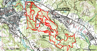
As you can see, there is a Google Map image on the left and a list of selected tracks on the right. Click the Info link next to one of the tracks and a balloon will appear on the map, providing an option to export as a Google Earth (.kml) or .gpx file. I downloaded the 11 tracks as .gpx files.

Topofusion_7There are other ways to do this, but I chose to open the saved .gpx files in TopoFusion and used its Cut Track feature to remove stray track segments. The result is shown in the screenshot to the left. I then transferred the tracks to my GPS.
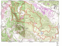
I was getting close to my goal, but I also wanted a good quality printed map.  As much as I like TopoFusion, it and other TerraServer based programs have very limited printing capabilities, and TerraServer topo maps are fairly low-resolution scans. So I transferred Annadel_mapthe tracks to National Geographic TOPO!, and printed the map shown to the right.

The folks at MotionBased have plans to incorporate waypoint management, so in the future you may be able to download those too. For the time being though, it’s a great resource for grabbing tracks placed online by other outdoor adventurers.


MotionBased: Online GPS mapping (review)

A couple of weeks ago I wrote that MotionBased, a website for online GPS mapping, had been acquired by Garmin. I’ve been playing with a Garmin ForeRunner 301 recently and used it to check out MotionBased, which keeps all your data online so that you can access it from anywhere. As a result, you can share trail info with others, though you do have the option of making your trails private. This is a great program for athletes, or anyone working on physical conditioning.

GPS based training

One of the strengths of MotionBased is its ability to integrate heart-rate data. It’s very cool to be able to overlay an elevation profile with your heart-rate graph. I had never thought about it, but my heart was pounding as fast going all out in the flats as when I was climbing a steep hill. Seeing such things is part of the wow factor for me; serious athletes will be more interested in seeing how long they stayed in various heart rate zones, and the multiple ways to view speed, distance and time data. This information is presented in both tables and graphs.

Multiple mapping modes

Now I like to stay in shape, but my perspective here is decidedly unathletic. I’m more interested in maps, and this is where MotionBased offers something other mapping software doesn’t.  Using their Map Player (which unfortunately will not yet work in Firefox), you can view a track superimposed on a street map, contour map, topo map, satellite image or elevation model!  You can even export the track to a .kml file for viewing in Google Earth. Here’s a link to MotionBased for a recent bike ride I did. Click the "Dashboard" button for a more extensive look.

Waypoints and routes are missing

No software has it all, and MotionBased has yet to add the ability to manage (or even show) waypoints and routes. But it is worth looking at for its other features. And it’s great to be able to view your trips anywhere you have an internet connection. If you own a Magellan or Lowrance GPS receiver however, beware—MotionBased is designed primarily to work with Garmin.

Cost

The free version, MotionBased Lite, gives access to mapping and analysis of your ten most recent activities. These limitations are removed with a subscription, which also gives you access to more extensive analysis features. Subscriptions to MotionBased Standard run $11.95/month, which is discounted 33% if you sign up for an annual plan.

This review just scratches the surface of a feature rich software program. I suggest trying it out yourself. Finally, stay tuned…in the near future I plan to post about the extensive data you can download from MotionBased for trip planning.