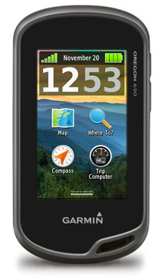
Hands on Garmin Oregon 650 review
On being an early adopter
I am an early adopter. Having owned many Garmin GPS receivers in the past, I find myself eager to experience the new features and functions included with each new hardware release. As many Garmin users are aware, this can mean months of buggy operation while software engineers continue to work out all the kinks in an effort to provide the functionality advertised for each unit.
Related units
- Step up to the Garmin Oregon 650t to get preloaded 1:100,000 scale topo maps for the US
- Or drop down to the Oregon 600 and you’ll give up the 650’s 8MP geotagging camera and internal rechargeable li-ion battery pack (although the latter is available as an add-on option for the 600)
- To see how the Oregon 650 stacks up against other models, check out our Garmin handheld GPS comparison chart
Usually, the software is stable and usable sometime within the first 12 months after release, and at some point much farther away the firmware will be as functional and refined as it will ever be. This is not necessarily a bad thing, as Garmin is very receptive to user input during this period, and I know of no other company that allows for direct user input while refining a product line.
In the past, this reputation has prevented many potential users from adopting Garmin’s newest devices until after they have sufficiently matured. Of course, these late adopters also miss out on being a part of post release development.
With the introduction of the Garmin Oregon 6xx, everything has changed.
A game changer
Garmin has produced several outdoor touch screen GPS receivers. The Oregon x00 series was first, followed by the Oregon x50, Dakota x0 series, and the Montana. Each new release built on the success of the last, offering new features and incremental improvements over previous models.
While Garmin’s newest Oregon 6xx series continues to build on popular features available with past models, this GPSr is far from an incremental or evolutionary step forward. The Oregon 6xx appears to be the first of (what I hope to be) a revolutionary new direction in product philosophy.
The Garmin Oregon 6xx software is very refined and quite mature, right out of the box. The Oregon 6xx is ready to perform, as is.
The Oregon 6xx is a game changer.
The basics
Discussing each and every function of the Oregon 6xx in detail would require more space than is available for this review. For this reason, this review will concentrate mostly on features and improvements new and exclusive to the Oregon 6xx. Detailed information is available at the Garmin Oregon 6xx wiki.
The Oregon 6xx offers the same dual orientation display available with the larger Montana, but lacks the ability to use a powered dock and provide spoken directions. This alone means the Oregon 6xx will not be a viable replacement for most Montana users.
Also carried over from the Montana, the Oregon 6xx allows the user to create one touch shortcuts (macros) allowing quick and easy access to many GPSr features and functions.
Borrowed from the Montana as well is the dual power option, allowing use of standard AA batteries or Garmin’s rechargeable NiMH battery pack that charges inside the GPSr. This feature is standard for Oregon 650/650t, and optional for 600/600t. Only Garmin’s NiMH battery pack can be recharged inside the GPSr.
The Oregon 6xx includes an additional User Button just below the Power Button that can be configured to initiate just about any function desired for single tap, double tap, and hold.
An improved Trip Computer now displays 33% more information on the screen with more data fields available on each page.
The Garmin Oregon 6xx includes 20 additional data field options not available on the Montana.
The Map Applications allows for individual KMZ Custom Maps to be enabled and disabled as desired.
The Oregon 6xx includes a 3-axis electronic compass with accelerometer tilt compensation that can be used in any orientation.
The Oregon 650/650t feature a modern 8MP camera that will take photos you won’t believe came from your GPSr. The included LED flash on these models also serves as a flashlight or emergency strobe beacon, and can be configured to repeatedly flash an S.O.S. signal.
GLONASS support
Originally introduced with the new eTrex series, the Garmin Oregon 6xx can also use GLONASS satellites in addition to standard GPS satellites to achieve quicker position fix times and maintain your fix under heavy cover and in deep canyons. I have yet to test the deep canyon claim, but am very eager to do so later this year when I visit Havasupai, in the depths of the Grand Canyon.
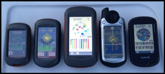
Satellite reception on various Garmin handhelds; Oregon 650 at far right
Some debate exists about whether or not GLONASS improves accuracy. Having more satellites available certainly will improve position acquisition times and help maintain signal lock under heavy cover. My testing suggests the unit is no more accurate with GLONASS turned on than it is with GLONASS turned off. This may not hold true for all locations and environments, and having the option to tap into more satellites when necessary is certainly a benefit I appreciate.
Garmin Oregon 650 screen
Perhaps the most obvious, if not immediately apparent change to the Oregon 6xx series is the new chemically strengthened glass multi-touch display. After using multi-touch smart phones for many years, I found previous Garmin touch screen GPSr units were not exactly intuitive to use. They worked, but never were as precise, or as fluid as I wanted them to be.
The new Oregon 6xx screen looks and behaves much like my iPhone screen. Scrolling menus, making selections, and panning the map screen all function as I expected. I have limited time testing the screen in the wet and with gloves, and have experienced no issues with either.
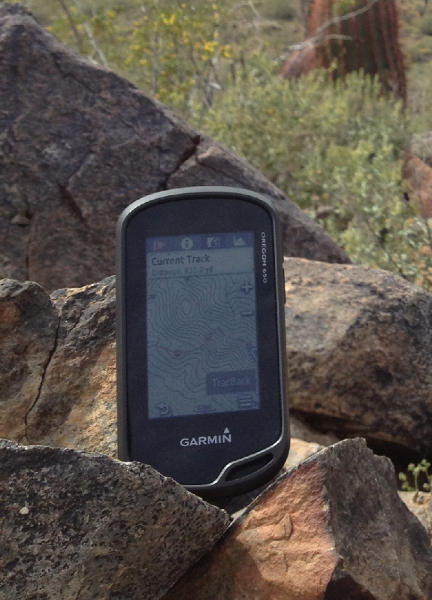
The Garmin Oregon 650 in its natural habitat
The display is very bright, and is as easy to see in direct sunlight as any smart phone. I have absolutely no complaints, and believe this to be the best display Garmin has produced for their outdoor line of GPSr. You will simply have to see the screen for yourself before you can decide.
UPDATE: Here’s a cool screen hardness test!
Wireless capabilities
Garmin’s BaseCamp Mobile iOS app
ANT+ has been carried over from previous designs, while Bluetooth has been added to improve data sharing capabilities. Larger files, including KMZ custom maps, photographs, and Adventures can be shared between compatible devices quickly and effortlessly.
iOS users can use BaseCamp Mobile to edit and transfer data between their Oregon 6xx, iOS device, and Garmin cloud storage. I spent some time playing with BaseCamp Mobile, and it functioned reasonably well, but still has plenty of room for improvement. I suspect future improvements and refinements will be coming, and have requested an Android version as well. My iPhone is due for replacement soon, and this time I will not be replacing it with another iOS device.
Current track
Debuting on the Oregon 6xx series, the new ‘Current Track’ application greatly improves track log management and workflow.
Gone are the days of having to exit the current application, opening the setup menu, and working through multiple nested option screens to manage your current track log recording options.
Including the ability to create shortcuts (macros) for some common functions on the Montana was a step in the right direction, but many operations still required navigating between applications to view and use all the information available. The Oregon 6xx provides complete track log access and control from one application.
The Current Track application icon (see image below) provides some basic information directly from the main menu screen, before you even open the application. This dynamic icon changes appearance in response to track recording status, displaying a green arrow while track recording is active, and a yellow arrow while paused. The border color of the icon indicates the current track color.
Garmin Oregon 6xx series track icons
The primary interface is divided into four screens, each easily accessed by selecting the appropriate tab along the top of the screen.
The Track Control (shown below at left) screen displays current track color, total time, and total distance. From this screen you can start and pause track recording, delete the current track, and save the current track, in whole or selected portions.
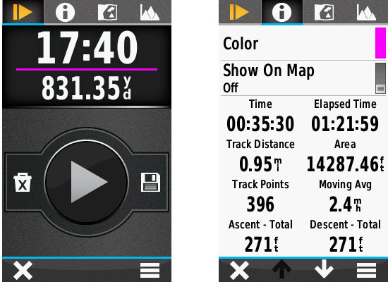
Track control screen shown at left; track information tab shown at right
Select the Track Information tab (shown above at right) to view detailed summary information for the current track, as well as controls to change the current track color, and show or hide the current track on the map screen.
The Map View tab (shown below at left) displays the complete current track on the map screen, providing direct access to a detailed track summary and map screen controls, and the TracBack functions to swap the start/finish points and guide you back the way you came.
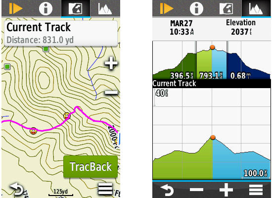
Track map view (left) and elevation (right) tabs
A fourth tab will open the interactive Elevation Plot interface (shown above at right), displaying minimum and maximum elevation information, and allowing the user to view and select any portion of the graph to view specific details. Here you can also see the ‘Future Plot’, an estimate of the track elevation ahead based on installed mapping data. The current track is always displayed in green, and the future plot in blue.
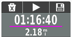
New track control dashboard
A new Track Control dashboard (shown at right) is also provided, allowing essential track log recording control from any application or main menu screen.
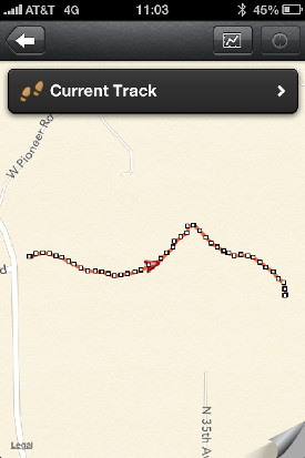
Additionally, Garmin has included two new Track Log recording functions: Auto Start, and Auto Pause. Auto Start will initiate Track Log recording each time the Oregon 6xx is powered on and the unit has a satellite lock. Auto Pause will temporarily stop track log recording when you stop moving, and start again when you do. The purpose of this feature is to remove the clutter that occurs in all track recordings each time you stop along the way for any period of time, such as when you stop along a hike to eat lunch.
Here is an example of a short hike with a Montana 650, and Oregon 650 with Auto Pause enabled:
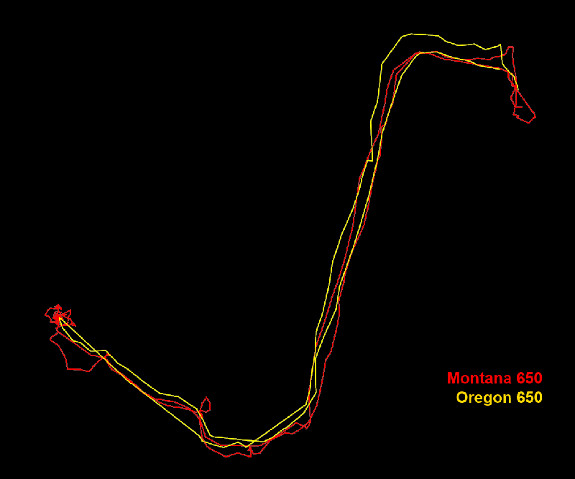
Montana 650 track vs Oregon 650 track with auto pause enabled
Having used the new Current Track interface for the past few weeks, I can’t imagine how Garmin could make track log recording management any more efficient, and I wouldn’t want it any other way.
Garmin Oregon 650 track selection menu
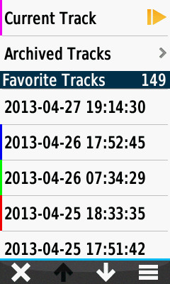
Track manager
The Track Manager application has also been polished and refined, offering more information and streamlined controls for all tracks saved to the Oregon 6xx.
The track selection menu not only provides direct access to all tracks on the device, but also provides track color information for tracks that are currently set to ‘show on map’.
Tracks are displayed based on proximity by default, and can also be sorted alphabetically or by creation date.
A ‘Spell Search’ function is also provided to help users quickly locate a desired track.
Once a track is selected, the user is greeted with a tabbed user interface allowing access to more information and more controls directly from the Track Manager screen.
The Track Information tab (below left) displays statistical data for the selected track, as well as providing controls to edit the track name, change track color, set track visibility on the map, and move the track between favorites and archived status.
The Map View tab (below center) displays the selected track with currently enabled maps, and provides direct access to a Track Summary information page, map controls, and a ‘Go’ button to begin navigating to the selected track.
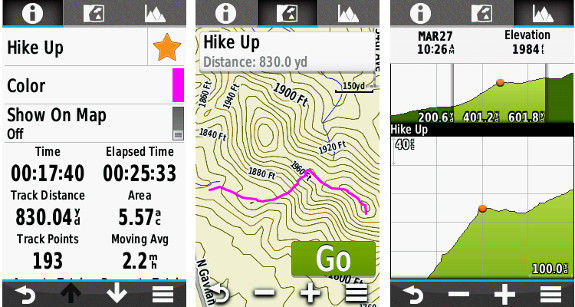
Track info, map and elevation tabs
An Elevation Plot tab (above right) provides detailed elevation information for the selected track. Select any position along the elevation plot, select the menu button, and ‘View on Map’ to view the selected position along the track on the map screen.
The Waypoint Manager application includes similar refinements, offering streamlined editing capabilities not previously available.
Geocaching with the Oregon 650
With all the other added features and refined functionality combined, the Oregon 6xx is already quite desirable, if not impossible to resist. If you are not a geocacher, the Oregon 6xx offers sufficient improvements to merit serious consideration. If you are a geocacher, the Oregon 6xx is the Holy Grail.
For the Oregon 6xx, Garmin has pulled out all the stops and put much effort into building the ultimate caching machine.
No limits. Unlimited. Limitless. These words are fair to use when describing the geocaching capabilities of the Oregon 6xx. Great improvements have been made to both the back end and front end of this device.
Previous paperless geocaching GPSr units were limited by the number of geocaches they could actively index. 2000 for the Colorado, Dakota, and Oregon x00. The Oregon 450/550 series is limited to 5000 caches, and with a 12,000 geocache capacity, the Montana was the best in class. The Oregon 6xx is capable of indexing as many as 4 million geocaches. That is nearly twice the number of geocaches currently available. On the entire planet.
Garmin created a new geocache storage format, GGZ, to help accomplish this, and is making it freely available to any who wish to use it. However, GGZ files are not required to enjoy the virtually unlimited storage capabilities of the Oregon 6xx. You can still load all your PQ’s and GSAK databases to the Oregon 6xx in GPX format, and have all the information for every single geocache available from the new and improved GeoCaching User Interface. Not as POI’s, but as complete geocaches with full descriptions, hints, photos, logs, etc. Every geocache.
The completely re-imagined GCUI also makes use of a now familiar tabbed menu interface with three tabs; Active Geocache, Geocache List, and Geocache Filters.
The Active Geocache menu (below left) provides quick access to the geocache description, photos, logs, hint, chirp details, next stage dialogue, and the geocache logging interface to log your finds.
The Geocache List (below center) displays available geocaches based on your location and enabled filters. Geocaches can be sorted by name and location directly from this screen.
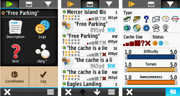
Garmin Oregon 6xx series geocaching screens
The Geocache Filters interface (above right) provides quick and easy filtering controls to decide which geocaches are displayed in the Geocache List as well as on the Map screen. Filter selections are dynamic and applied immediately. Custom filters can be created, saved, and applied instantly as well.
I have been using the new GCUI for several weeks now with more than 50,000 complete geocaches loaded on my Oregon 650, all in GPX format. The Oregon 6xx is still very quick and responsive, even more so than my Montana with only 10,000 geocaches loaded.
Conclusion
After using the new Oregon 650 for nearly eight weeks, I have found the device to be a very capable unit worthy of serious consideration. The Oregon 650 has surpassed nearly all of my expectations, and provided additional features and benefits I wasn’t aware I wanted, and now do not want to be without.
A word of caution, however. Regardless of intended use for this GPSr, be it hiking, riding, geocaching, or whatever, once you’ve used the new features available with the Oregon 6xx, you may just find your other GPSr units collecting dust. A lot of dust.
You will not be disappointed.
More Garmin Oregon 650 reviews
Other Garmin Oregon 650 resources
- The Garmin Oregon 650 owners manual
- Our Garmin handheld GPS comparison cart
- The Garmin Oregon 6xx series wiki
- The official Garmin Oregon 650 web page
Compare prices on the Garmin Oregon 650 at these merchants:
- Check the current Garmin Oregon 650
price at Amazon
- Get the Garmin Oregon 650 at GPS City
- Or buy the Garmin Oregon 650
direct from Garmin

Thanks for review. This is what I can’t understand: “Auto Start will initiate Track Log recording each time the Oregon 6xx is powered on and the unit has a satellite lock.”. How this is different form any other GPS? And what happens, when you turn it off?
If you have Autostart OFF, and Track Log Recording is paused when you turn the Oregon 6xx off, when you restart the Oregon 6xx, Track Log Recording will still be paused until you manually start it.
If Autostart is enabled, Track Log Recording will start again as soon as the Oregon 6xx has satellite lock.
Thanks. Then Autostart ON is a standard mode and Autostart OFF is a new function, but I can’t see much use for it. And probably it can lead to some problems for users, who forget about this settings when turning on registration.
Not really a new function, just a different way of presenting the same options already available on previous units.
With the Oregon x50, or Montana, in each profile you could select one of three options for track recording:
1. Record, show on map
2. Record, do not show on map
3. Do not record
Options 1 and 2 are now enabled with “Autostart On’, as displaying the current track on map is configured directly from the new Current Track application.
Option 3 is now enabled with “Autostart Off”.
Then I assume that “Autostart OFF” really means “stop registering immediately”, lol
How do you convert from geocaching.com .gpx to GGZ? I assume GSAK will / has an import filter…
The current build of GSAK will export GPX files as GGZ.
I was using a database of over 50K caches as GPX files, total size nearly 470MB.
Converting those to GGZ in GSAK resulted in a 76MB file.
The Oregon 6xx is MUCH faster when using GGZ format.
No information is lost using GGZ files.
Very nice write-up Andy!
Regarding the screen, I’m still not quite clear on the technology. Is it transreflective (can it be seen without the backlight)? I think this is a must-have for a handheld… in bright direct sun my Montana looks a lot better than my iPhone. 🙂
Assuming that it is transreflective, then that would explain the low resolution. As you know, 400×240 would hardly be “state of the art” on a smartphone (my iPhone 4 is 960×640 for example).
For me, the low pixel count on the new Oregon is a deal-breaker. Physical size aside, I don’t think I could go back to a lower resolution screen than the Montana. It will be interesting to see if they use this same technology on the Monterra (if such a product even exists… it has been removed from Amazon’s website).
It is transflective, and is a lot easier to read in sunlight than the Oregon 450. It also seems to be a bit better than the Montana in terms of the variety of angles where the screen is still perfectly readable. Specifically because the screen uses more transparent glass, rather than the plastic resistive touch layer.
I would hope that the next Montana design brings in the same screen tech at least.
Yes, Transflective. In direct sunlight, I can run the backlight all the way up and down, and not see any difference. The screen is that bright!
As for the extra pixels on the Montana, wait until you have used the Oregon 6xx for a few weeks.
I have not put my Montana to rest, but the Oregon is seeing much more use, and I love my Montana.
I think none of Garmin transflective screens has problems with direct sunlight, the more light the better visibility. Worst condition is shade, where is not enough light to work in reflective mode and can be too bright to see backlight. This is the case where old Oregon or Dakota were a bit difficult to read. I hope new Oregon can cope better.
The Oregon 6xx screen is as easy to read as any of my iPhones. With the new glass screen and no resistive film overlay, the display is very sharp, and crystal clear.
Boyd Ostroff said: May 1, 2013 at 1:21 pm
“For me, the low pixel count on the new Oregon is a deal-breaker. Physical size aside, I don’t think I could go back to a lower resolution screen than the Montana.”
Actually the resolution of the new Oregon 6xx is much higher than the resolution of the Montana.
Oregon 6xx = 160ppi or 25865 pixel/inch2 and Montana only 138ppi or 18774 pixel/inch2 (inch2=square inch).
But this is the reason why the Montana has such a bright screen.
Could you post some pictures taken by 650?
I can not. My Oregon 650 is a test/evaluation unit, and does not have the final spec camera installed. So, any photos I did post would not be representative of the final product. I am surprised at the quality of the photos I have taken with it, and think others will be also.
I wanted to add that as soon as I receive my consumer version Oregon 650, I will post some images to the Wiki. As a matter of fact, any user can send me photos taken with their Oregon 650 for potential posting to the wiki for all to see! I will be adding a photo gallery as soon as I have enough photos, so send them in!
AtlasCached at gmail dot com
Send me a note once they are up and I will link to them from the review.
Is there a limit to the size of geocache GPX files, or the number of geocaches you can have in an individual GPX file?
I am sure there is a limit to the size of GPX files, but I have not found it. One of my GPX files was > 20K caches alone.
Just ordered mine (well back ordered anyway…). Excited to see it.
Congratulations!
Do you have any other Garmin GPSr’s? or will the Oregon 6xx be your first?
Either way, I am sure you will not be dissapointed 🙂
Rich, What can you say about altitude measurements?
Do Ascent-Total and Descent-Total (in trip computer as well as in track) match real field records?
I predict, it is easy to check when ascending and descending stairs or hills with known altitudes’ difference…
To clarify, when you say Altitude, are you referring to Elevation?
Ya’re right I meant altitude=elevation.
I will do some real world testing for this specifically and report. Rich may beat me to it 🙂
Andy and Rich,
Thanks for the interesting and persuasive review Andy.
Rich, Thanks for the site, and your ongoing commitment to ‘everything gps,’
I concur. GPSTrackLog is a critical part of my week, especially the Waypoints feature each weekend!
Thank You Rich!
And a huge thanks to you for guest posting! Great review!
Rich and Atlas Cached
I notice significant difference that depend on track recording method.
Elevation gains and loses are irrealistic when 1 sek. time interval, and they seem correct when 10 meter distance interval is done.
Nevetheless, both in eTrex30 and Dakota20, Trip computer shows always too small values of Ascents Total and Descents Total.
What is Your opinion about Oregon 6xx comparison between track and trip computer readings of elevation gains and loses?
I will also try to do some specific testing for this question and report back, but you must realize, the more sample points you take, the greater the delta values will be, both positive and negative.
just wonder in any differences between track record and trip computer.
Elswhere (groundspeak forum) it was shown exact values in both.
Usually, in all other outdoor Garmin units (GPSMap, eTrex, Colorado etc.) total elevations’ ascents and descents differed much between track and trip computer.
Are there any differences in Oregon 6xx too, or Garmin decide to calculate elevations in the same way both for track and trip computer?
If [Setup > Tracks > Advanced Setup > Trip Recording > When Tracking] is selected, the Trip computer will only record data when the current track log is active, and all data will agree.
If [Setup > Tracks > Advanced Setup > Trip Recording > Always] is selected, the Trip computer will record data regardless of current track log activity, and data between them will not agree.
http://garminoregon6xx.wikispaces.com/Setup+-+Tracks
With past units, setting the tracklog to once per second would help with this.
Cool! Garmin’s “game changer” can now do a larger fraction of what my Motorola Atrix 4g phone has been doing for me for years. Once they get the bugs worked out. Whoopee. My Garmin 62st will remain in my pocket as a backup to my far more capable smartphone.
Once per second is not good setting for altitudes.
With such interval one never gets proper elevations.
I’d rather recommend distance interval.
Anyway, what about “window’s sill” test? Does Oregon 6xx show any elevation gains if lying still in the same position?
My eTrex 30 even after several hours shows properly: zero gains and zero losses unless “variable elevation” is set.
Every second a bit different elevation is read which influence much ascents and descents.
It is due to fluctuations in GPS signal, esp. in standstill position.
Not unless you have the barometric altimeter disabled.
OK, let’s wait and see how Oregon trip computer works with altitudes.
Note, that in all former Garmin outdoor handhelds trip computer used quite different alghoritms for calculating ascents and descents…
What is the Life span of the battery pack compared to actual batteries? Does it give you the 15 – 16 hour battery life like most units? Does it come with a car charger or is that even an option that you can purchase aftermarket?
I have experienced better than 14 hour lifespan from the included NiMH battery pack with my Oregon 650.
You should not use aftermarket car chargers with Garmin GPSr units, strange things tend to occur.
Garmin offers a reasonably priced Power Plug to mini-usb cable that you can use to power most Garmin GPSr units in the car.
Vehicle Power Cable
Part Number: 010-10851-11
What do You mean: “14 hour lifespan”?
What was the setting then: 1.GLONASS ON/OFF, 2.Screen ON/OFF, 3.Map:”Track Up” or Data Screen ON? and 4.ANT+ ON/OFF???
From my experience these four factors matters the most.
It is significant that GPS+GLONASS drain considerably more batteries than GPS only…
14 hour lifespan means just that. The Garmin NiMH battery pack lasted more than 14 hours before requiring charging.
My common settings vary between GLONASS on and off, screen always on, Map always track up, and ANT+ always enabled.
Not sure what you are trying to determine here, as each and every user will have different workflows and use unique settings based on personal needs, resulting in a greatly varied experience.
Knowing that GLONASS and ANT+ drains energy I usually switch OFF both.
I assume that with disabling both it is easy to get 20 hours of Oregon 6xx battery lifespan and enjoy two days trip (aprox. 10 hours hiking each day) without much care of batteries, am I right?
I have an old eTrex legend hc, and had (sold last year) an Oregon 450.
I’ve also had a forerunner 210, 610, and currently using a 910xt. Love it for the fitness tracking functionality. Looking to compliment with a mapping capable unit ( since I sold my old Oregon).
Just want to add that since this review was written, I have increased the number of caches loaded on my Oregon 650 to more than 100K, all in GGZ format, and the Oregon 650 is still just as zippy as with only a couple thousand caches loaded. No appreciable loss in performance!
Hi. Nice review! 🙂
I was just wondering if Garmin has made any changes to how they handle geocache-related waypoints compared to earlier Oregon-units. Before I have not found any easy way of finding something like the parking coordinates for a geocache except by searching for a waypoint by name. Will it be possible to see child waypoints directly from the cache description?
I would like to add to this item. Garmin should take a look at Android app C.Geo, This app does this quite right. From the main Geocache screen, you can hit a button showing all child waypoints and from there you can start navigating. Would be great if the new GCUI would put this in the Next Stage function. If they are available: show child waypoints, if not show the screen to enter next coordinates manually.
Ooh, maybe it will show up asa Monterra app!
This process is still the same, but the product is very new, so let me pass this along to the software team.
Four new models – I understand the camera, and I am nearly convinced that $80 is worth it for the built in camera and battery pack. What I don’t understand is the T models. Yes, there is some additional built in memory but are the purchased topo maps any better than the free ones you can download? Is there something else I am missing about the T model that would make someone want to purchase it?
Robert, the NiMH Battery will work with any of them, and charge in any of them, but is only included with the 650/650t.
The 650/650t models include the 8MP camera AND LED Flash/Flashlight/Strobe/Emergency Beacon.
In the past, I would have suggested passing on Garmin’s 100k topo maps, but my understanding, although I have not confirmed myself, is that the Oregon 600t and 650t will ship with 100k Topo v5 in the USA, which are freshly updated as of January 2013 with much more accurate information when compared to older versions.
You can always copy the maps to a computer and use the space for other maps in the future if you like.
Garmin also sells highly detailed and routable 24k topo maps, at a price premium, but the US versions are getting pretty old as they have not been updated since 2008.
I will be getting a 650t myself when they become available.
I guess I’m just trying to figure out whether the price difference for the T versions is worth it.
How do the Garmin topo’s compare to maps from Gpsfiledepot?
Garmin’s maps would have to blow the doors off of the free ones to justify the price unless there is something else I’m missing.
Hopefully they will be available soon!!!
Depends on the GPSFileDepot map you choose. Some are good, some are great, and some just are.
The NW Topo/NW Trails may be one of the nicest offerings, but if you don’t live in the Pacific northwest, it is of little consequence.
If you see a map there for your area, you can load it into BaseCamp and compare it to the 100k and 24k topo maps Garmin supplies, and make a final decision before final purchase.
Personally, I always go for the non-t models, since I want 1:24k maps on my GPS. The t models may come in handy if you travel the country a lot and don’t always have time to load maps for a trip.
That’s pretty much what I had decided as well but it seemed like such an obvious choice that I wanted to make sure there wasn’t something special about the t model that I overlooked. Thanks all for your input!!
Some of us were very impressed with the field demo an the recent event in Oklahoma. So impressed that three of us have made advanced orders and two more are waiting for release.
Will the use of the additional Satellites effect accuracy or just allow faster location time.
Is there a ballpark date we can expect the release of the 650. We’ve noticed times changes from later to sooner to later on the web site.
The review covering geocaching additions and improvements has us excited.
From everything I’ve read so far, the addition of the GLONASS satellites will not improve accuracy in an area where you have good reception. They could, however, give greatly improved accuracy when in confined spaces where you are not able to get a good lock onto only the standard GPS satellites.
Again – I am no expert, this is just from what I’ve been reading so far.
Additionally, the unit apparently get’s a lock much faster than previous models though whether that’s to the addition of GLONASS or not I have no idea.
GPS City has the release date for the 650 set at May 28th now though take that with a grain of salt since they also have the date for the 600 set for the 12th and REI has had them in stock for about a week now.
I found a little problem in the Track Manager of my Oregon 600 (v2.60).
After selecting Current Track: at the bottom of the screen you can scroll down by hitting the white arrow, the screen scrolls down but then immediately scrolls upwards again.
After selecting another option at the top of the Track Manager screen and returning back to the Info screen my GPS sometimes crashes when I try to scroll down again with the white arrow! The screen will freeze (sometimes with random stipes on it) and I have to reset the GPS by pressing the power button for a few seconds.
It also occurs that this screen gets instable and starts moving up/down a few pixels.
Scrolling down by moving the screen downwards works OK.
Can anyone confirm this?
After selecting Current Track, on which tab are you scrolling? I don’t see the ability to scroll on any of the four tabs.
Current Track opens with the info (i) tab by default. I can scroll down on this page and get 3 more parameters. The screen is on this page: http://garminoregon6xx.wikispaces.com/Applications+-+Current+Track
The problems I have are a bit at random, sometimes it works but after selecting another tab and going back to info scrolling down with the arrow results in strange behavior (stripes or even a total freeze of the GPS).
This is a bug I reported during testing, and apparently it has not been resolved. I have reported it again to [email protected].
Another little bug: after setting up the power switch to take screenshots all other key-configurations are disabled.
I recently read on Garmin’s site that the 6XX will record your logs in the field.
My question is will they upload to the caching website as logs in a batch mode (as some phone applications do) or will they go in as field notes which have to be painstakingly clicked on one at a time to become a log?
Logged caches are recorded in a text file that can be read by GC.com, where you can choose to edit/modify your log or use it as is.
That’s what I thought. Maybe they’ll get it to where it can work like some of the phone apps(geosphere) that allow you to create your logs then send the file up to GC.COM without having to go through their edit/ choose process of one at a time.
Thanks for your answer.
Regarding the Camera in the 650. Does it have a physical button for the camera or is it operated from an screen button?
Operated from the screen:
http://garminoregon6xx.wikispaces.com/Applications+-+Camera
Oh and regarding operating the camera. In addition to the screen, you can map the user button to operate the camera. The only trick is there is not audible sign when a photo is taken, making self portraits somewhat interetesting . But it does work pretty well – 1 push opens the camera and a second snaps the photo.
Hi, thanks for your great Garmin Oregon review. How did you manage to download 50000 geocaches from geocaching.com ?
My pocket queries can have maximum 1000 caches. I would like to copy all caches of germany to the new oregon ( i will buy soon).
Can you help me, how to get all?
And did you convert to ggz or leave all in pure gpx format?
50,000 / 1,000 = 50 PQ’s 🙂
I first used individual GPX files, which worked just fine. When GSAK added support for GGZ, I exported them all as a single GGZ file, which is about 20% size of GPX, and allows the Oregon to index and read caches much more quickly!
http://garminoregon6xx.wikispaces.com/Applications+-+Geocaching
Can you check given the new placement of the mini-B USB plug facing the back of the Oregon 6** units and not to the side (down) as in previous Oregon units, if its possible to connect the cable while a carabiner or car clip is connected? I sometimes use this Auto Nav Kit (https://buy.garmin.com/en-US/US/shop-by-accessories/accessory-kits/automotive-navigation-kit/prod15428.html) with a Oregon 450, but reading a groundspeak forum, someone states “you need to pull the caribiner clip off in order to plug in the mini-B USB plug”
The usb plug sure looks pretty close to the back spine attachment, from a image in the User’s Manual:
http://img29.imageshack.us/img29/7374/oregon6xusb.jpg
I modified the clip with a small round file. Still functions perfectly but now don’t have to remove it to charge or connect the GPS
I am shopping for a replacement of my 60CX, and trying to determine if these new Oregon/Montana units auto-record “unlimited” tracklogs as GPX files to the SD card, the same way that my 60CX does. What are “archived” tracklogs, and are they different from “saved” tracklogs? The owner’s manual doesn’t have much technical detail, and I am concerned that the Oregon owner’s manual says that only 200 tracklogs can be saved.
I am also wondering about the Oregon’s antenna, which I assume is a “patch” type, compared to the Quad Helix antenna in the 60CX. Does the Oregon have to be held horizontally to get proper SV signal reception and best accuracy? I generally carry my 60CX in a shirt or jacket pocket, upright, and am wondering if this would not work well with the Oregon/Montana unit’s patch antenna.
The Oregon 6xx will continue to record GPS track logs (so long as they are enabled) for as long as you have free memory, but only to the device, not the uSD card.
More info on Favorite Tracks vs Archived Tracks here: http://garminoregon6xx.wikispaces.com/Applications+-+Track+Manager
The GPS antenna in the Oregon 6xx series works well in any orientation, and also provides access to the Russian GLONASS satellite constellation, allowing faster fix times and better coverage under heavy cover.
Question regarding memory management on the Oregon 6xx :
1. Can the user move Tracklog files from internal memory to the uSD card in the field? I am thinking about situations like hiking in a remote area, where I don’t have a computer available with which to download the Oregon, and the unit’s internal memory is running low.
On the other hand, would I be correct in thinking that, with 1.8 gig of internal memory in in Oregon 600, or 3.6 gig in the 650, there is probably enough internal memory to record several months (maybe years) worth of daily tracklogs? My 60CX accumulated only 2.5 megabytes worth of tracklogs on a two-week vacation last winter (with average 6 hours use per day), so maybe I am worrying about a non-issue? Thanks!
Definitely not worth worrying about. Even with as little as 300mb, you could record nearly 5 years of 6 hours a day track logs before running low.
Hi, does anybody have any examples of photos that were taken with the Oregon 650’s camera?
I’m trying to decide whether or not to get the 600 or 650 and my decision really will come down to the quality of the 650’s camera.
Thanks!
I only have one so far, but more will be posted in the coming weeks!
http://garminoregon6xx.wikispaces.com/Photo+Album
Thanks!
I would mostly use the 650’s camera to take fish pictures while fly fishing.
My past cameras were never water proof and I’m not so good at keeping them dry.
🙂
If you have not previously used a smart phone with a camera (the camera on the Oregon 650 is similar in capability to an 8 megapixel smart phone camera). please keep the following in mind :
1. Camera phones have no lens hood, so they are much more susceptible to image degradation from glare than the lens on a purpose-built camera. To get decent photos with an Oregon 650, always try to shoot with the sun behind you, or shade the lens with something (a hat, piece of cardboard, etc).
2. Because the lens on an Oregon 650 has a fixed focal length and aperture, the depth of field and minimum focal distance are pre-defined by the design. This means that the range of camera-to-subject distances that yield the best looking images is much less than can be achieved with an actual camera. Sample images that you see on the Internet can be assumed to be the “best” that the photographer managed to get out of a larger group that probably contained many poor images.
The point I am making is that any camera phone is severely limited. If you want to get really nice photos of your adventures, you might be better off with the non-camera version of the Oregon, then take the money you save and buy a 12 megapixel compact camera (I am a Canon fan, but Nikon, Pentax, Fujifilm, Olympus, Panasonic, and Sony all make compact cameras that give excellent photos). To Geotag your photos, there are software tools that compare the tracklog from your GPS with the EXIF timestamp in each photo, then add the Lat/Long and elevation to the EXIF header. I think you can then drag the photo itself into Google Earth and it will rotate you right to where the photo was shot. One last item: if you heed my advice about getting a real camera, get one that supports shooting in RAW format! RAW images have a much wider range of adjustability than JPEG’s, which means that you have a much better change of recovering a decent shot from an under-or-overexposed RAW image.
Good advice for serious photographers, but I seriously doubt anyone is considering any GPSr to replace a real camera. If you are a serious photographer, you already realize the limitations of any smartphone or GPSr camera. On the other hand, if you have been happy using your smartphone camera to snap photos here and there, you will be happy with the photo quality from the Oregon 6xx.
Chris said:
“I’m trying to decide whether or not to get the 600 or 650 and my decision really will come down to the quality of the 650′s camera”.
I would buy the Oregon 650 anyway because you get a much bigger memory of 3.6 GB instead of 1.6 GB only in the 600!
True. That’s more than twice the memory.
Thanks!
a DSLR, it is not. But having said that, it does a pretty respectable job.
http://www.flickr.com/photos/utahmanbrian/9053816894/
http://www.flickr.com/photos/utahmanbrian/9053821572/
They say the best camera is the one you have with you. Whilst out enjoying life, this ensures I always have one with me. 😉
The main reason I am going to buy the new Oregon 650 (when it’s available finally) is the ability to charge the NiMh-battery pack in the device.
It eliminates the hassle of opening and replace the battery and
more important to re-adjust the compass.
All Oregon 6xx will charge the Garmin NiMH battery pack, you do not have to get a 650 to take advantage of that feature.
The 650/650t include the NiMH battery pack, while the 600/600t require you to purchase the NiMH battery pack separately.
Yes thanks, I’m aware of that.
FYI, I have the 600 and it is recharging my own nimh batteries that I put in there – I did fashion a doohickie that holds that button down when the batteries are in in. I saw somewhere that is needed for it to do the recharge.
And when your batteries leak or explode inside the GPS because you disabled a safety device, Garmin will be more than happy to sell you another at full price.
I am amazed that anyone would spend$400-$600 USD on a GPS and then compromise on a $25 USD battery.
The security device can NOT protect the GPS from a leaking battery.
I don’t see a problem to disable the security device,
as long as NiMH-batteries are used –
it makes no difference whether to use the Garmin battery pack or two other NiMH rechargeable batteries.
When I first read about the poster fashioning a “doohickie that holds that button down when the batteries are in in” I thought it was foolish. But having seen photos of Garmin’s battery pack it looks no more than 2 standard 2000mAh NiMH batteries strapped together at a vastly inflated price. The “strap” depresses the button in the battery chamber; this is the unit’s battery pack “auto-detection.”
Am I missing something? Does anyone have hands on access to the battery pack? Is there any circuitry built into it pack or anything special. Or is it simply the equivalent of a couple of NiMHs strapped together (or fashioned with a doohickie)?
Ni-Mh Battery Pack Rating:
2.4v 2000mAh, 4.8Wh
I do actually have one right here in front of me. No, no wiring, just two batteries stuck into a little plastic harness held together with Garmin’s warning sticker.
That being said, not all rechargeable batteries are created equal and it may very well be that some rechargeable batteries will not hold up to the power that is put out by the unit when recharging them. Like you said before – I’d hate to see you void your warranty over a $24 battery pack.
You can stick rechargeables in there all day long but I don’t think I’d jump on the bandwagon of bypassing Garmin’s little security device just to recharge them in the unit.
As I stated before all NiMH batteries are the same regarding the voltage, it is always 1.2V or 2.4V if put two together like Garmin’s battery pack.
The difference is only the capacity and that should be 2000mAh equal for both.
So in my eyes the self made NiMH’s strapped together are as good as the Garmin battery pack.
the reason there using a battery holder to trigger the charging is that it is not possible to charge other batteries. Just to make sure nobody is trying to charge normal batteries instead of nimh.
With the battery pack the know it can be charged.
You can charge your battery pack in a normal AC charger, you can split the batteries.
http://gps-info.nl/s/battor6xx .
Hi gxceb0t,
You said:
“I did fashion a doohickie that holds that button down when the batteries are in.”
Can you please tell me how you could manage to disable the security device to recharge your own NiMH batteries. I would like to my NiMH batteries, too.
Thanks
How is the battery level meter on the Oregon 650? Is it accurate? My only complaint I have about my Oregon 450 is the battery level meter has never worked great. Thanks
Most digital devices (like cameras) monitor voltage, and report percentage of battery charge remaining as a function of where the voltage is at any given moment compared to a range of voltages from Maximum to whatever low voltage cut-off the device is designed to. The problem with this is that the voltage in NIMH and Lithium Ion type batteries doesn’t slope uniformly down as they discharge. It starts high when freshly sharged (1.4 volts), quickly drops to 1.25 volts, stays steady at 1.2 volts for quite a while, then drops quickly to the cutoff voltage as the charge nears exhaustion. Unfortunately, this behavior isn’t completely uniform across brands of batteries, so it is difficult for a device manufacturer to design battery gauge software that reports accurate battery percentage for every kind of NIMH you might stick into the device. Bottom line, if reliability of your GPS is critical to the success of your venture, I would not carry only NIMH cells, as even the Eneloop kind have a faster rate of self-discharge than Lithium or Alkaline cells. When Garmin says a set of “AA” NIMH cells will run (for example) an Oregon 6xx for 16 hours, they are talking about under ideal conditions: brand new 2000mah low-self-discharge (eneloop) batteries from a reputable manufacturer, freshly charged, and limited amounts of time with the backlight on. Your mileage may vary!
Excellent information Larry!
As you state, each NiMH battery discharges at a different rate based on brand etc. If Garmin were to use a permanent battery (like an iPhone, for example) in the GPSr, they would be able to write the software specifically for that battery and have a very accurate gauge.
With dozens of brands of batteries for each user to choose from, the battery gauge can only give a general representation of battery level remaining.
For those users who want to use NiMH rechargeable batteries with tier Oregon 6xx and want the power meter to read accurately, I recommend using Garmins NiMH battery pack. The Oregon 6xx automatically recognizes this device and one can assume the software for the power meter is calibrated precisely for this power source.
Upgraded my Oregon 450 to the 650 I have one question about the Geocache list when doing a spell search what is the maximum distance will it search and can this be change. When I try to search 300Km away I am told “Cannot find, change search parameters”.
Please see this link for detailed information:
http://garminoregon6xx.wikispaces.com/Applications+-+Geocaching#x-Geocache%20Selection
Good info!! I like the search near feature.
Thanks!!!
I like the link thanks. It will answer many questions.
Two questions:
1. If I go with an Oregon or Montana as a replacement for my old 60 CX, I will probably want to carry it in a shirt or jacket pocket at least some of the time. Is this a problem with the touch screen, like “butt-dialing” is a problem with touch screen cell phones?
2. Is the Montana actually too big and bulky to carry in a typical shirt pocket? In doing a quick comparison, I feel like the Montana 600 is a better value than the Oregon 600, so I am leaning toward a Montana. It is only $70 more, and you get up to 6 hours longer battery life thanks to 3 AA batteries vs. 2, and 3 gigs of RAM vs. 1.5, and of course a screen with 36% more pixels.
1. If you do not lock the screen, yes for both units. The Oregon 6xx includes an extra user button that can be programmed to respond to a single click, double click, and long hold. I have mine set to toggle the screen lock with a long hold. The Montana has a single power button, and similar to the Oregon 6xx power button can be programmed for a single or double click action. A long hold of the power button is for powering the unit on/off.
2. Todays clothing styles, yes, the Montana is too large for a shirt pocket. Large pocket flannel shirt, probably OK, but you are going to know the Montana is there. The Montana screen is much larger, and has more pixels (which require more energy to cycle), but you pay the price with bulk. In many ways, the Montana is superior to the Oregon 6xx, and in many ways the opposite is true.
The most important consideration is your primary purpose/use for the GPSr.
If you are hiking and trail riding most of the time, definitely the Montana, but if your primary function is to geocache, the Oregon 6xx can’t be beat.
Hey Atlas, I just wanted to say thanks for pitching in and answering so many of the questions here. It’s a big help.
My pleasure!
I like my new Oregon 600 very much – so far no complains.
But just one thing is rather bothering me:
I am using the Oregon in the “map” mode.
When I then tap on the screen e.g. to enable the dashboard a needle appears on the screen and a text is telling me the location of the needle.
This happens always if I am not exactly hitting the icon to switch the dashboard on or off.
Does anybody know how to switch of that function???
You shouldn’t get that unless you tap the map. Tapping the menu icon or data fields won’t trigger it. There is no way to switch it off that I know of.
Thanks Rich Owings !
Do you know how this “tapping the map” function is officially called???
I call it the pin. It’s actually a pretty cool feature. Tap the map and start panning; the map will move underneath the pin, allowing you to more precisely select a point on the map.
Feature Request #16 created just for you, sir!
garminoregon6xx.wikispaces.com/Common+Issues#RF%2016
Thanks a lot to Atlas cached, good idea.
I bought a Oregon 600 last weekend. So far I really like it. Coming from a Delorme PN-60w so I’m having a bit of sticker shock on the maps. But the UI is clean and readable, which for an older guy with vision to match is a biggie.
So I just got off the phone with Garmin. The 600 will accept up to a 32gb micro SD card. Caveat – it must be a name brand, high quality card. Only maps and photos are stored on the SD card.
Topo 24K has routable roads, but is not searchable by street address. City Nav allows searching for addresses. But City and Topo apparently don’t coexist well. City must be disabled to search Topo POIs.
So I’m thinking (hoping) that I could search City for an address, create a waypoint, disable City, go to the waypoint in Topo, and then route the trail.
Apparently BaseCamp is more forgiving. (???)
Lots to learn…
If you have created a gmapsupp.img mapset file in MapSource or BaseCamp, and it contains tiles from different source maps – for example: US 100K Topo, Canada Topo, US 24K Topo, BlueCharts, Inland Lakes, and City Navigator North America – you will find that City Navigator is always the topmost layer. It obscures all of all other maps in the mapset. I don’t know why it was designed this way; I guess it’s probably so that road auto-routing always has priority. Anyway, to see something on any of the other maps, City Nav has to be turned off. I know how to enable/disable various map layers in my 60CX, but I don’t have an Oregon or Montana (yet) to compare with. I assume these newer touchscreen GPSr’s also have commands for the user to switch various map layers on and off.
Yes, toggling layers on and off is so much easier with the 600, even compared with the 450. With the list of layers/products showing it is one touch on each to toggle.
I remember the old days of picking and choosing the optimal set of tiles of maps from different products that would fit in my 60C’s memory and then waiting ages for the mapset to build and get sent to my 60C. The next weekend I would be going to a different area and would have to do this all over again. I guess the 60CX made this a lot easier? But with the Oregon it is liberating. Note you are not restricted to a single gmapsupp.img. You can rename the .img files to what you want so you can have one per product if you want.
In fact thinking about it, these days if you choose multiple products to install on your device from Basecamp they are uploaded as separate img files anyway so you do get one per product.
YEs, 20 maps total, not exceeding 4000 tiles (map segments) in total, regardless of location (GPSr or uSD). More info here:
http://garminoregon6xx.wikispaces.com/Maps
Really? Does it auto-rename them?
It certainly seemed to auto-rename them the last time I did this, so I did a quick test last night to confirm before I ran out of time.
In what I think is the latest Basecamp and Oregon 600 selecting the SD card, I went into two of installed (3rd party) products at random, drilled down to select some random tiles from each and uploaded them in one go. I expected from past experience to get a single gmapsupp.img but instead I got 2 img files, each automatically named after the original products. In the past I would have done this in separate passes for each map product, renaming each in turn.
Yes, Rich, the current version of MapInstall, which is what BaseCamp uses to load maps to your Garmin GPSr will auto name your maps in separate IMG files, as outlined here:
http://garminbasecamp.wikispaces.com/Send+Map+BaseCamp
My 60CX, with a 4 gig card, could hold a mapset with 2025 tiles and a max file size of about 3.8 gigs. My most-often used mapset had all of the US and Canada portions of City Nav North America, all of the National Parks 24K Topo, enough Blue Charts to cover San Francisco Bay and the San Juan and Gulf Islands (between Seattle and Vancouver), a few tiles from Inland Lakes, and the western portion of US Topo 2008, from the west coast to about 103º W longitude, to cover the western states National Parks that I am most likely to travel to. Building this mapset in MapSource took many hours, so I would usually start it right before going to bed and let it run all night. That 2025 tile limit puts a serious crimp in trying to build a comprehensive gmapsupp.img file. I can’t wait to upgrade to an Oregon or Montana, with a 4000 tile limit.
This is the key to being able to enable/disable specific types of maps (load each one separately and rename them as you go)… http://gpstracklog.com/2011/05/loading-multiple-maps-to-garmin-devices.html
@ kieth:
Do not get overwhelmed, as there will be a huge learning curve involved. You can store much more than photos and maps on the uSD card. Almost anything other than Adventures and Geocache photos can be stored on the uSD card. Adventures were originally advertised as working from the uSD card, but currently only function from the GPSr itself.
http://garminoregon6xx.wikispaces.com/Files+%26+Folders
Just picked up a 650t today at the REI store in Portland Oregon. Got the only one in stock. It’s charging right now, but from what I’ve seen so far, it is a vast improvement over any of the previous Oregons. I’ve used a 300, 400t, 450t, and 550t, and while I like them, the display on htis one blows them away. I’m wondering how long it takes for the initial battery charge with the unit right out of the box? I’ve had it on the charger for about 3 hours now and it’s still showing that it’s charging. One othe quick first impression is that the unit seems to resemble the Magellean Explorist series in terms of look and feel. Will be testing the geocaching limits of it this weekend.
Rich – Greetings from Happy Valley, OR 🙂
So the 600 has a very accessible Setup Maps | Configure Maps menu to enable / disable layers.
I love the display. I wish it had a light sensor though. ASAIK the backlight level needs to be manually tweaked. If I had it up cuz I was using it in the dark, then forget to turn it down the next day when I’m in the sun (and hence have no idea the backlight is on) the battery will drain faster than necessary.
Is there a way to snap the map back to my current location?
Happy Valley? I’m over in SW PDX near St. Vincent’s Hospital. Are you part of GEOregon, by chance??
So far I haven’t had a chance to do much with the 650t. In going through the menus, I did notice a setting for for daylight settings. Setup>Appearance>Mode gave me the options of Auto/Day/Night, but all it seems to do is to change the colors. Under the Battery Save option, if you have that enabled, it turns off when the backlight times out. I have my backlight timeout set for one minute.
Rich,
Not sure what CEOregon is, so I guess not. lol But I’ll goggle it…
I’m using battery save = on. So my power button single click turns the screen on and off. But that seems to interfere with taking screen shots. I’ve not found a way to map screen shots to another button mode. So I think there is a potential issue there.
I loaded part of Topo 24K West. Then it disappeared so I had to load it again. Probably something I did, but I’m wondering what. Even with the Topo 24K installed, Setup Map | Configure Maps doesn’t show any layer that looks like it’s the 24K maps. So I’m not sure how to turn the layer off. And I don’t see where they are stored on the Garmin when browsing in Windows Explorer. But I do have a bunch of map layers that came with the 600 for demo I assume. Gotta delete them. But the 24K maps look great.
I was able to search for street addresses on the 600 using only Topo 24k. Where to? | Addresses… But it was a bit off on locating my house. I’ll be putting City Nav on the 600 soon.
The lack of an ambient light sensor is unfortunate. I’m just leaving the backlight level set as low as possible after every use.
Still learning, but so far I love this GPSr. Very cool!
GEOregon is the local geocaching group. We met tonight at the Roundtable Pizza in Gladstone.
I bought the City Navigator today from Garmin. Went with the download version, loaded directly onto my 650t. Seems to be working okay. Found my first cache with it tonight, seem pretty accurate. Still figuring out all the bells and whistles.
@Kieth, simply select the back arrow at the bottom left of the map screen to return to your present location centered on the map screen.
IF you do not have the current 2.70 firmware installed, the Battery display likely will never let you know when it is fully charged.
Make sure you check the FAQ’s here, especially the first one!
http://garminoregon6xx.wikispaces.com/FAQ
@ Rob – Thanks!… http://gpstracklog.com/2013/06/load-multiple-maps-to-your-garmin-without-renaming-them.html
I don’t like to pay too much money for Garmin-maps, so my I idea is to download and install OSM – OpenStreetMaps or OpenMtbMaps (for mountain bikers) on my Oregon 600.
So I did it and I was quite surprised that the map quality it not bad at all.
But “Routing” with this OSM’s is some how strange and not functioning well.
It leads some how to the target destination but the proposed tracks are not as I wanted it, e.g. I want the “minimize distance” mode but the result is wrong because I know the shortest track in my area better.
Does anybody have experience with OSM’s regarding routing?
Do I have to apply certain special settings?
Or should I forget the whole thing?
This issue – unpredictable auto routing – is not just with OSM. On my 60CX with “official” Garmin maps (City Nav North America) it happens also. When navigating to a destination in a rural area, when there might be 5 or more alternative routes, the “shortest distance” mode sometimes picks a route that is obviously not the shortest distance. I think the issue has something to do with the way roads are classified, from multi-lane Interstate down to unpaved hiking trails. It seems like the auto-routing algorithm tends to avoid the smallest, lowest ranked roads, even though they might be good, paved roads, in favor of highways, even though the distance is longer. Another frustrating thing is that an auto-route planned at home in Mapsource isn’t guaranteed to be the same route that will be calculated in the GPSr once you are on the road and driving. I have found that, to be sure the GPSr follows the route I planned in Mapsource, I have to use intermediate waypoints at all of the intersections and turn points.
If you ever go driving in the Southwestern U.S., in desert areas, DO NOT LET YOUR GPSr ROUTE YOU OFF OF A PAVED ROAD ONTO A DIRT ROAD! City Nav North America contains thousands of miles of dirt roads in the Mojave Desert that your GPSr will use in Route calculations if you are set to “shortest distance”. A few motorists have gotten themselves into serious trouble in Death Valley National Park in recent years by blindly following their GPSr onto long-abandoned and unmaintained dirt roads that shredded their tires, leaving them stuck somewhere. Two of these incidents have resulted in fatalities. Garmin is aware of the problem and is supposed to be eliminating most of these unmaintained dirt roads in future releases of City Nav.
I did have a problem with auto-routing for a while with the OSM’s as well – until I realized I was an idiot. I was excited to see that there were routable maps for both auto and bicycle so I downloaded and loaded both onto my new 650. Well imagine my annoyance when the darn thing wouldn’t even route me along the highway!!
Yea…the bicycle maps had priority. I turned those off and viola, it works perfectly. Anyway, figured I’d share in case anyone else happens to make the same bone headed mistake I did.
Yes, you must only have ONE routable map enabled at any given time, or else strange occurrences will be witnessed!
Does OpenCaching.com automatically download the newer non-GPX format?
I downloaded about 150 geocaches with 4 photos. I can see the photos in the Garmin\GeocacePhotos\… hierarchy. I see no evidence of the GPX files. OpenCache appeared to load them directly to the GPS. (The activity indicator spun around for a while and then turned into a check…)
Right-click Ejecting the Garmin from Windows Explorer doesn’t seem to do anything. So I end up pulling the USB from the 600 while it is still showing in the Explorer. (Win7) And when I go to Geocaching on the 600 there appear to be no geocaches to select from. ???
This is probably all operator error. But it seems pretty straight forward. Just not working…
Help?
Should see a GPX file named after the area of the OX download in the GPSr\Garmin\GPX\ directory.
If you download complete OX database, it will be a single GGZ file located in the GPSr\Garmin\GGZ\ directory.
When you ejected the 600 from your PC, did it have a uSD card installed, or is that slot empty? I am guessing empty (no uSD Card).
How far is the closest cache from you present locations? The Oregon 6xx only displays caches within a 100 mile radius in the geocache list, however ALL geocaches are always displayed on the map screen.
Atlas,
If I have the 600 tethered to the computer with BaseCamp open, I see GCs listed. I can drag them up into a list, find them on the map, etc.
If the 600 is untethered, when I go to the Geocaches app all I get is “Select a geocache to get started”. But there are no geocaches to select from. DUHHHH… You have to select the middle icon on the top tab bar to see the list of geocaches. So again, I’m reminded of my limited mental capacity! lol
So, OpenCaching, Geocaching, GSAK, Pocket Queries, GPX, GCZ, paperless caches – YIKES!
I signed up to both sites. Are there more? Geocacing has a lot more listing. Is OpenCaching a wannabe? Can I download paperless GCZ from Geocaching without jumping through hoops?
Too much to learn…
Rich Owings, thanks for this site. I’ve learned so much already. I would not have bought the 600 without your review. I was eyeing a 450. Glad I went with the 600. Really nice UI.
Atlas Cached, thanks for all your help. Reading over the posts (for the nth time) I’m picking up that you work for Garmin (?).
So I have not installed a uSD card yet. My hope is to install all of Topo 24K West, City Nav, select Birdseye sat images, and maybe that NW Trails thingy I saw mentioned earlier. (Is that a Garmin product?) Plus some GCs and limited screen grabs.
Sound doable? Suggestions on uSD card size?
Thanks
@Kieth, I do not work for Garmin. You should have no issue installing the maps you mentioned on a single uSD card. I use a 32 GB uSD card in my GPSr. They are inexpensive, and you can never have enough room, especially if you start downloading a lot of the BirdsEye satellite imagery. Be sure to check the Maps page at the wiki for specific map installation information.
Just for fun I have downloaded from Garmin http://www8.garmin.com/vehicles/bundles/allvehicles.html
the “bicycle” direct to my Oregon 600.
I thought it is some how funny when I’m riding my mountain bike.
But I am not able to get it on the screen.
If I select the bicycle I still get the default arrow.
Are there any restrictions for certain profiles or what is the matter?
I want to buy an oregon 600 or 650. I dont need this cam. But what about the built in memory?
Is the 1,5GB of memory of the 600 big enough? How much of tis uses the system itself and how much is free and left for me? Or better deal with the 650 and 3,5GB ram?
I will put all my maps to the sd card.
Anybody made experience with this? Is 1.5GB enough or not?
Thanks, Olli
Personally I would get the 600 and use a microSD for anything that wouldn’t fit in internal memory.
i agree. but for example geocaches i cannot put on the sd. i also cannot save tracks or waypoints on the sd while on the run. or is it possible meanwhile and i am wrong?
so hoch much space would be left for this data on the device?
You can put geocaches on the SD. Click on the links here under installed memory to see how much space is available… http://garminoregon6xx.wikispaces.com/Hardware
ah, cool ! Thanks for this site!
I finally got my Oregon 650 set up and I really like the way it functions. The screen in the sunlight is very nice ( are you listening smart phone makers) .However I accidently deleted the SHOW ALL function under geocache set up and can’t seem to get it back. I moved back a screen and did the restore defaults but it didn’t bring it back. Even when to some of the other options to restore defaults. Still no luck
I was in Settings>Geocaching>Filter setup > then the menu in the menu was an option called show all. I touched it and there was a delete option in the list. In my mind I was thinking delete the cache I was looking at. I should have know better. It deleted my Show All. Any suggestions on how to get it back?
Possibly Setup > Geocaching > Filter Setup > Show All.
You will simply have to recreate it. Will only take a couple minutes to do so.
http://garminoregon6xx.wikispaces.com/Applications+-+Geocaching#x-Geocache%20Filters-Create%20Filter
Thanks Atlas Cached
One other question. Is there a way to set the user key to toggle from automobile driving to direct routing?
When using the gps to ‘drive’ me to the cache it’d be sweet to be able to hit the user button to take me to direct routing. The closet I’ve been able to get is to toggle from what ever sceen I’m on to the routing choices, then hit direct. Not a huge deal but would be convenient.
Would it be easier to set up a shortcut to switch profiles from Automotive to Geocaching?
Thanks Rich. I’ll take a look at it.
Anyone have any luck getting your geocaches from a ggz file to show up in BaseCamp? Everything stored in a gpx format shows up fine but it’s like the caches in the ggz files don’t even exist.
Makes it difficult to create a route when you can’t even select your points.
BaseCamp does not yet support GGZ files. You would think Garmin would make sure their interface for the GPSr supported the same files the GPSr supports, but the BaseCamp guys are in a world of their own….
I did bring this to their attention in March, but they have yet to add GGZ support.
An FYI/Plea for help! (my Garmin Oregon 650 experience thus far)
My geocache list only displays certain caches in the list and not others (I only loaded a dozen or so caches). Whats more is that the unit loses more of the caches as I use the device. I have done both the soft and hard resets with no results. I called Garmin, they took me through the same procedures, same results. They had me delete my caches and install ones only from OpenCache (GGZ files), same results. It does not matter if they are on device storage or an Micro SD card. When I plug the unit in and go to BaseCamp all of my caches show up. Garmin tech could not help, and told me to have a nice day!
Yesterday while out on a cache, I went to one of the caches that it would see, found the cache, went to mark it as found and the device completely locked up. Took out the batteries, restarted, and it came up with no base map or my Garmin 24k maps, the unit was completely unusable! The Unit has the most current firmware v2.70.
I want to like this device, but it has really starting to annoy me.
Anyone else have any of these thing happen? Any suggestions would be appreciated.
ps: It’s good to be prepared, I always carry a map and compass. You just never know when technology will fail you.
Paul, as others have suggested, try keeping all of your geocaches and maps on the uSD card so when an indexing issue occurs, you can simply power off, remove uSD, power on, power off, install uSD, power on again to force a complete re-index of all data in the field without the use of a host computer.
I suspect one of your files may be corrupted. WHat maps are loaded, and how were the geocaches loaded, as individual GPX or a single GPX?
Hi Atlas,
I too keep my maps and caches on my SD card, I’ve done the power down/remove card/power up etc., doesn’t work, I still only get some caches back. I thought I had found a work around when I noticed the cache icons appeared on my screen (even though they were not in my list), I touched on one of the icons and my list reappeared, since that time the device has lost the caches once again, and I have not been able to duplicate the process. Other than the Base map and a partial install of Garmin 24K Northeast maps, I have nothing else in the device (or card). I have downloaded some GPX files from geocaching.com directly to both SD card and device, same result and almost random to which ones I see each time. I have also imported GPX files (and GGZ files) directly into BaseCamp and then into the 650, same results. I have removed the GPX folders manually from both card and device (per Garmin tech advice), then reinstalled, still no go. BTW, I also installed the GPX files one at a time, some of the caches that I have installed (and found) no longer load into the gps. Garmin had me work solely with Opencache.com GGZ files, still had the same problem, Thats when they said “Thank you for calling, have a nice day”.
Paul, please take this discussion to the wiki so we can determine the cause of your issues there, and possibly create a bug report for Garmin.
http://garminmontanagpsr.wikispaces.com/page/messages/Home
Oops, wrong wiki 🙂
Here is the correct wiki:
http://garminoregon6xx.wikispaces.com/page/messages/home
Thanks Atlas, I will
After much trial and error, I removed all filters from my filters list (made a backup of them first), and was able to regain my list of caches. Interestingly as I look back, the problem started when I marked my first found cache. I’m glad that I got them back, but leaves me puzzled by why this occurred when I marked the cache as found. I may try putting the backup filters in one at a time to see if any particular one may have caused this (I did not make any changes to the original settings prior to all this). But I first want to use the device a while longer to see if things are stable. I really hope this is behind me, I really do want to like this GPS, all the other features have been everything I hoped they would be.