Sunday, March 18, 2012

About Bob Mueller

P/C Bob Mueller, JN is an active member of the United States Power Squadrons. He is an ABC3 instructor, a Vessel Safety Examiner and a Squadron Emergency Response Assistance Team Leader. Learn more about P/C Bob Mueller, JN at bereapowersquadron.org.

Garmin Approach S2 review

Garmin Approach S2 review

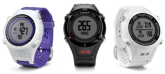
Hands on with the Garmin Approach S2

The Garmin Approach S2 is a GPS watch designed for golfers.  It comes preloaded with over 30,000 courses around the world, and includes free updates which add more courses over time.  The internal GPS allows the watch to read out the yardage to the front, back and center of the green. read more

Garmin GPSMAP 741xs review

Garmin GPSMAP 741xs review

Hands on review of the Garmin GPSMAP 741xs

The Garmin GPSMAP 741xs is an all new marine chartplotter from Garmin.  The GPSMAP 741xs has a 7″ diagonal color screen and an all new look.  In the past, Garmin has used silver bars at the top and bottom of the case.  These have been removed and replaced with an all black look that is similar to the ultra high end 8000 series.
read more

Garmin GPSMAP 547xs review

Garmin GPSMAP 547xs revew

Hands on with the Garmin GPSMAP 547xs

The Garmin GPSMAP 547xs is an all new marine chartplotter recently introduced by Garmin. The GPSMAP 547xs has a 5″ diagonal color screen and an all new look from Garmin. The traditional silver bars at the top and bottom of the case have been removed for a very stylish all black trim ring.  The major upgrade over the previous generation is wireless capability (WiFi and Bluetooth) and the sounder module was upgraded to include CHIRP technology.

read more

Garmin BlueChart Mobile app for iOS released

Garmin Bluechart Mobile app

Garmin Bluechart Mobile app screenshot from iPad

The Garmin BlueChart Mobile iOS app is now available for download from the App Store. This new app will allow your iPhone / iPad to function as a chartplotter using Garmin BlueChart maps. The app is free, while charts are available as an in-app purchase. read more

New Garmin chartplotters announced

Garmin GPSMAP 741xs

New Garmin GPSMAP 741xs chartplotter

Garmin has announced new models in their marine line of chartplotters and combination chartplotter/sounders. Features and capabilities have been upgraded and enhanced at many different levels.

read more

Garmin GPSMAP 541s review

Garmin GPSMAP 541s marine chartplotter review

Hands on with the Garmin GPSMAP 541s

The Garmin GPSMAP 541s Chartplotter is an incremental upgrade to the discontinued GPSMAP 540s.  The GPSMAP 541s has a 5″ diagonal color screen and the same Garmin appearance is maintained with the silver bars at the top and bottom of the case.  The major upgrade is the ability to interface with NMEA 2000 networks for engine diagnostics, weather instruments and additional uses.  The GPSMAP 541s comes pre-loaded with United States Coastal Charts and also has a SD card slot for additional charts.  The SD card can also be used for transferring waypoints, routes and tracks.  The GPSMAP 541s includes a built in sounder module, that allows direct connection to a transducer for depth and fish finder functions. read more

iNavX Marine Navigation for iOS review

iNavX for iOS review

Hands on Review of iNavX Marine Navigation for iOS

The iNavX marine charting app is targeted for recreational boaters.  This app allows navigation using NOAA raster charts and a few other proprietary vector and raster chart formats.  Users can create waypoints & routes and also record tracks.   read more

Navionics Marine & Lakes for iOS review

Hands on review of Navionics Marine & Lakes: US & Canada HD

The Navionics Marine Charting app is targeted for recreational boaters.  This app allows viewing the proprietary Navionics Nautical Vector Charts on your favorite iOS device.  Users can create routes and record tracks, which can be shared with friends using Facebook, Twitter, and email.  The routes can also can be uploaded to certain fixed mount chart plotters that might be found on a boat.  The Navionics app will function as a chart plotter displaying your position on the chart with the enabled route making it somewhat practical to use as a chart plotter while underway. read more