
Hands on with the Garmin GPSMAP 62s
It’s finally here… The Garmin GPSMAP 62s brings a long-awaited update to the fabled and much-loved GPSMAP 60CSx, which has reigned supreme as the gold standard handheld GPS for more than four years. During that time, Garmin experimented with new interfaces, first with the Colorado series, and later with the Oregon and Dakota lines. These have been fine-tuned through many software updates, adding things like paperless geocaching and
the ability to add custom maps and aerial imagery.
With the 62 series (and the boater friendly companion 78 series, which shares the same interface), Garmin has married the best features of the 60/76 models, with many of the advantages of the Oregon line.
The problematic high-resolution screens found on the Colorado and Oregon lines did not make it to the 62 series (although I should note that this problem has largely been solved in the latest model, the Oregon 450). Before we get into the details, lets look at some closely…
Related models
- Drop down a notch to the GPSMAP 62 and you’ll lose wireless data sharing, the barometric altimeter, triaxial electronic compass and the micro-SD slot; still, this one has enough internal memory to satisfy most people’s needs
- Going the other direction, the GPSMAP 62st adds pre-loaded 1:100,000 scale US topo maps to the features found on the 62s, but with all the free maps available, there’s little reason to bump up to this model
- But you might want to step up to the 62sc to add a 5MP geotagging camera
- To see how the GPSMAP 62s stands up against other Garmin models, check out my Garmin handheld GPS comparison chart
I’ll discuss the display and feature set first, then look at performance
Portions of the following were adapted from my review of the previously released Garmin GPSMAP 78s and other units with shared features.
Garmin GPSMAP 62s display
With transflective TFT screens, the greater the pixel density, the less light that can be reflected back to the user. In order to maintain the bright screen found on the 60/76 series, Garmin left the resolution (160 x 240 pixels) alone. Screen size remains unchanged too, at 1.6 x 2.2”. The 62 and 78 series do enjoy an increased range of colors that can be displayed (65,000 vs. 256 in the 60/76 series). The result is a bright display, not quite as large or as high resolution as the Oregon series, but with much better visibility in a wide range of conditions. I definitely noticed the lower resolution, but these are the tradeoffs you make. The only time the screen seems cramped to me is when I have a dashboard showing on the map screen (discussed more below).
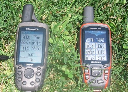
Shown above is a photo taken in full sun, without backlight, comparing the 60CSX and 62s. It is difficult to capture screen visibility on film, but I find these two displays comparable in a wide range of conditions.
Garmin GPSMAP 62s interface
Garmin hit a home run on the interface. They did an excellent job taking the best aspects of the Oregon series and making it work on a non-touchscreen unit. I think it is actually better than the Oregon except for when it comes to text-entry, where the touchscreen excels. The 62/78 series interface makes it much quicker to navigate main menu items.
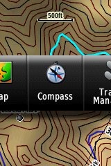 A Page Ribbon menu appears when you press the Page or Quit buttons (see image at right). Just like on the 60/76 series, these buttons advance through pages in forward or reverse order, respectively.
The Page Ribbon menu item that appears is the next screen in the sequence. After a second or two, that screen will automatically open. Or you can press Enter to go there right away, or continue pressing Page or Quit to advance to other pages in the sequence; stop on one and it will open. Page Ribbon items and their order can be customized. I prefer this interface to the old style, but you may not. In that case, you can set the unit to a classic style menu and get the old 60/76 series functionality, eliminating the Page Ribbon.
Here’s a quick video I shot, showing a bit of the interface:
Newer features on the Garmin GPSMAP 62s
The 62 series inherited a number of features from the Colorado, Dakota and/or Oregon series. These include the ability to utilize Garmin custom maps and BirdsEye aerial imagery, a tri-axial compass, new customization options, advanced track navigation, wireless data transfer and paperless geocaching. None of these were available on the 60/76 series; I’ll explore each in more detail.
Custom maps and BirdsEye imagery
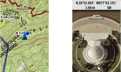
Garmin custom maps allows you to put just about any map image on the 62s. Found a PDF park trail map online? Add it to your GPS! The image at left below shows a custom map — a USGS topo (raster) image. You can read more about this feature by checking out my posts on Garmin custom maps.
With Garmin’s BirdsEye aerial imagery program, a $29.99 annual subscription allows you to add aerial imagery to the GPSMAP 62s. Since I don’t yet have a BirdsEye subscription for my unit, I’m showing a Jefferson Memorial aerial image using Garmin custom maps, but hey, you get the idea.
Tri-axial compass
Having a tri-axial compass means you don’t have to hold the unit level while navigating. The downside is that the calibration process is more complicated than that for a two-axis electronic compass. It’s the same procedure that is used on the Dakota 20 and Oregon x50 series — here’s a brief video I shot of it. The compass should be recalibrated every time you change the batteries in the unit.
Customizing the Garmin GPSMAP 62s
The 62s offers lots of options for customization. I highly recommend you take the time to set up the following.
Page sequence – You can customize the page sequence by choosing Main Menu > Setup > Page Sequence. This will allow you to select which pages appear in the page sequence and their order. The Page and Quit buttons move forward and backwards (respectively) through pages. I usually put the map screen as my first page and the trip computer last; this way I can toggle between them with the page and quit buttons.
Profiles – The 62s comes with recreational, geocaching, automotive, marine, fitness and classic profiles. You can switch profiles by going to Main Menu > Profile Change. Or create a new one by going to Main Menu > Setup > Profiles. Select the new profile to give it a name. Any changes you make in menus or other settings will be retained in that profile. So start changing things! Want track up when geocaching and north up when biking? No problem. How about a separate profile that just shows USGS topos or aerial imagery? The possibilities are nearly endless.
Data fields – You can change data fields on just about any screen that has these; simply press Menu > Change Data Fields.
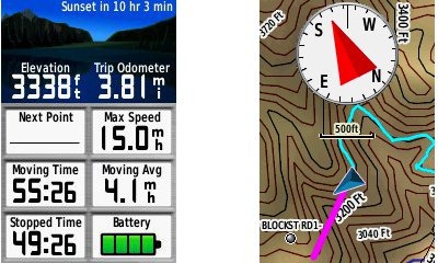
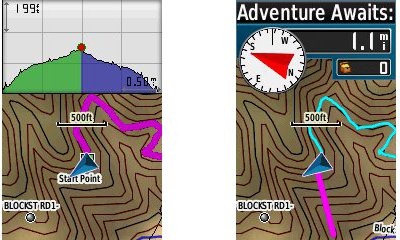
Dashboards – Instead of data fields (and in some cases in addition to), you can select a dashboard for the map, compass and trip computer screens. Choices (depending upon page) may include automotive, stopwatch, small or large data field, recreational, compass, geocaching or elevation plot. I’ve included screenshots showing the last four below. For the trip computer and compass pages, you access this via Menu > Change Dashboard. For the map screen, choose Menu > Setup Map > Data Fields > Dashboard. The one downside here is the small screen on the 62 series; using a dashboard can significantly reduce map real estate.
Track navigation
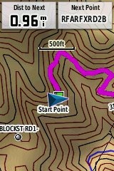 With the GPSMAP 62s, you can select a track to navigate and a route will be created. Waypoints are automatically generated for major high and low elevation points, and start and finish; these and any user waypoints along the track are added to the route. I’m a heavy user of track navigation. If I head out for a trail I’ve never traveled before, I do a search online for tracks (favorite search terms are .gpx, gps, trail name, and park name) and load the track to the device. One advantage of this new track navigation feature is that, unlike typical backcountry route navigation, you’ll get an estimate of actual trail distance rather than “as the crow flies” mileage. Screenshot at right.
Paperless Geocaching
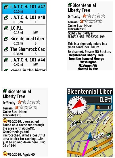
The 62 series is a nice GPS for geocaching, as it is set up for full paperless support, meaning you can see the description, logs, and hint, and you can log your attempt (find, DNF, etc.) for later transfer back to geocaching.com. Speaking of which, full access to these features requires a premium membership at geocaching.com. Shown below, clockwise from top left: closest geocaches, geocache description, map with geocaching dashboard, recent logs.
Wireless data transfer
The GPSMAP 62s is capable of wireless data transfer with other compatible Garmin units. You can transfer waypoints, tracks, routes and paperless geocache details.
Other features of note
Most of the following aren’t that new, but they are worth mentioning anyway:
Route, Track and Waypoint management 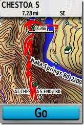
The GPSMAP 62 series has excellent route, track and waypoint management tools, including:
- Waypoints – The ability to project a waypoint, average location, set proximity alerts, and to reposition a waypoint at your current location.
- Tracks – You can choose to hide or show multiple tracks on the map, view an elevation plot, and give them a custom color (17 colors are available). The image at the right shows a track in red (a record of a previous trip). The color of the active track may also be changed. There’s a good thread at the GPSMAP wiki that delves more into track archiving and storage. The 2.44 beta firmware update brought additional archiving improvements; hopefully this will make it to a non-beta release soon.
- Routes – You can view a map of the entire route, edit the route, reverse it and view an elevation plot.
Ability to utilize free maps
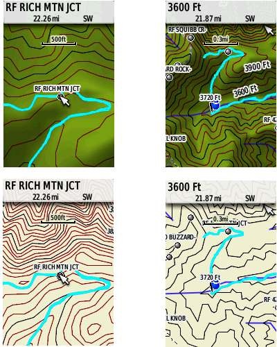
One of the most awesome things about Garmin mapping units is the huge number of free maps available. My favorite site for these is http://gpsfiledepot.com where you can find 1:24,000 scale vector topo maps for most states. You can see a sample in the bottom two screen shots below. If you want shaded relief though (shown in the first two shots), you’ll need to go with Garmin’s own product, either Topo US 100K or their new 1:24,000 scale series.
Auto use
While I would prefer the Oregon 450 as a dual use unit, due to its touch screen (which is significantly larger too), the 62 series is capable of giving turn-by-turn directions when loaded with City Navigator maps.
Under the flap and inside
Under the protective weather cap is a mini-USB port and MCX external antenna connection. Just so it doesn’t trigger questions, I’ll mention that the item beside the antenna connection is a screw. Inside the battery compartment is a micro-SD slot for additional map and data storage.
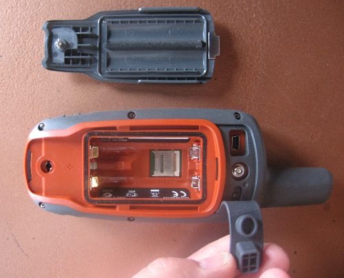
One hardware note here. The battery holders can be very tight with rechargeable NiMH batteries. I actually had to pry the batteries out of one unit I tested, though my wife could remove them with her amazingly strong fingernails! The batteries popped out of the other test units with a good slap, and I expect that even tight ones will loosen up over time.
Carabiner and mounting system
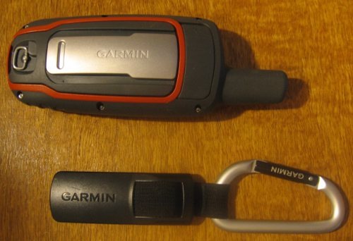
A rail mount on the back of the unit allows the included carabiner to slide onto the device (shown below). This is the same system used on the Colorado, Dakota and Oregon lines so the related accessories are interchangeable. I’ve heard some people say they don’t trust the carabiner mount, but after using it on my Oregon for a couple of years, I can say that I’ve never had any problems with it. Personally, I really like it and find it very convenient for clipping onto my pack.
Garmin’s bike mount uses the same system, as shown below. I didn’t like this at first, since it’s just a zip tie system, but after a reader suggested using pliers (to pull the zip tie tight) and a screw driver (to press against the base of the zip tie slot), I’ve found that I can get it quite tight. I’ve never had a unit pop off the mount, though it is possible to slide it on incorrectly, so be aware of that. Also, low profile mounts such as this one seem much safer to the rider, in case of a crash, than ones that protrude.
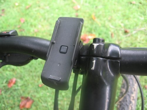
Auto mount kits that utilize this rail mount connection are also available.
Garmin GPSMAP 62s performance
UPDATE: The issues discussed below seem to have been resolved, and I am now very happy with my own 62s.
A tale of three units
I requested a GPSMAP 62s from Garmin and immediately put it on my mountain bike and went out for a test run. I was pretty shocked at the tracklog errors I saw. The unit also exhibited some abnormal behaviors just sitting still under open sky, with a lot of cycling between low and high readings. I talked to Garmin support, tried a hard reset – everything I could think of, but still saw these problems. At this point, I assumed I had a defective unit and arranged for them to send me a replacement…
Unit # 2 was better, but I still saw high accuracy readings (80’+) and some tracklog errors when mountain biking. I was seeing no such problems reported in GPS forums, so what was going on? Unlike the first one, the second unit appeared to be a pre-production model, further muddying the waters. I was beginning to feel pretty unlucky. Had I really received two dogs in a row? The sister unit, the GPSMAP 78s, had been so good. What in the world was going on?
Third unit and a theory
So I decided I needed another unit to test and, suspecting that Garmin might take a dim view of sending me a third unit, I went down to REI and plunked down my own money’; I figured I’d end up buying one anyway. When it gave me less than stellar results, a theory started forming in my oh too slow gray matter.
I never tested the 78s on my bike, because it didn’t work with standard mounts. Could it be that these new models had problems under canopy, at speed? While I was seeing wide swings in accuracy readings, the tracklogs looked pretty good except on downhill runs. After a couple of weeks of struggle, I had a theory to test. So lets break down performance by use and environment:
Mountain biking (speed + canopy)
Notes on methodology – Tracks were set up to record points every five seconds, WAAS was enabled. The 62s and my 60CSX were both mounted on opposite sides of my handlebars, in a position closer to horizontal than vertical.
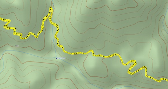
The image below shows a portion of the 62s tracklog from a representative out and back trip. On the downhill run there are numerous places where the track doesn’t match well with what was recorded on the way up. In one place the error approaches 250’.
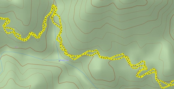 Compare this to the same section of 60CSx track below, where track separation maxes out at around 65’.
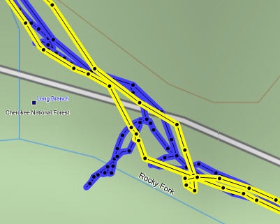
However, the 60CSx exhibited much worse spidering / scattering at rest stops, up to 150’ at one point, shown below (60CSx in blue, 62s in yellow).
Enter the beta
In my final round of tests before posting this review, I installed the 2.44 beta firmware, which also updated the GPS firmware to version 4.52. You can see in the 62s track below that these wild errors appear to be gone. I did see track separations of up to 110’ on the uphill and downhill runs, but nothing as large as the previous errors.
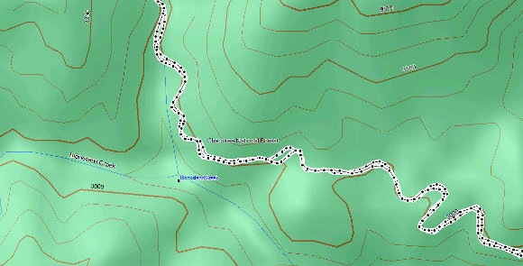
On the same ride, the 60CSx also showed track separation errors of around 110’, and once again exhibited significant spidering/multipath errors when stopped.
It appears that the 2.44 beta has significantly improved performance for mountain bikers and others who use their GPS receivers under canopy at faster than walking speeds. Except where indicated, the remainder of the tests discussed below were made using non-beta software.
Hiking under canopy
Here I used the same methodology I did when testing the 78s:
Recordings were made out and back, on foot, with the 78s in my right hand, and the 60CSx in my left. This meant that one unit may have been closer to a cut slope on the trip up, but the other unit was in this position on the trip down.
Tests were made in multiple locations. Basically, I saw more instances of tracklog separation with the 62s; these were in the 35-50’ range. I saw less of these with the 60CSX, but it threw larger variances, up to about 80’. And again, the 60CSx exhibited much more “spidering” when stopped.
Speed or canopy?
So going fast under canopy was problematic in my early testing, but going slow under canopy wasn’t so bad. How about speed alone? To test this, I stuck both units on my car’s dashboard and recorded tracks while driving. Both performed very well, though the 62s went off by about 70’ at one point. The issue appeared to be more about the combination of speed and leaf canopy, than about either alone, but again, it looks like the recent beta has largely fixed this.
Geocaching performance
I did some geocaching testing, but it is much harder to draw a conclusion here. Generally, the 62s put me a little closer and tended to settle down significantly faster than the 60CSx. One time, when standing 3 feet from a cache, it showed me 2’ away, with the compass pointing almost directly to the cache. Impressive! But alas, I am at the whims of the accuracy of the published coordinates when geocaching.
Battery life
I tested battery life using freshly charged Sanyo Eneloop batteries with the backlight off, and left it sitting under light canopy, undisturbed until the unit shut down. The unit was set to collect trackpoints every 30 seconds. The tracklog and total time data field showed that the unit ran for 17 hours and 59 minutes, a couple hours shy of the rated battery life of up to 20 hours.
Altimeter
In my most recent tests, with the 2.40 and 2.44 firmware, I found total ascent readings to be very accurate, on par with the 60CSx, which has always been my most reliable indicator of elevation gain. I was pleased to see this, since the Oregon series has bounced back and forth between accurate and inaccurate readings, depending upon firmware version.
Creaks and bugs
There have been a lot of reports on message boards about units that creak when pressed on opposite sides of the case. I have seen, um, heard this on each of the three units I tested. On the first, you could hear it when powering the unit of and off. It wasn’t as bad on the other two I tested. Whether this portends other problems over the life of the unit is unknown.
With new handhelds, you can typically expect some bugs in the early firmware. The 62s certainly has these, but many are minor or esoteric. One of the more common and unresolved complaints I’ve heard is that the reported battery level stays on full, and then drops to 3/4 charge shortly before the battery dies. Until this is fixed, when the battery level shows any drop, it’s nearly time to change to a new set!
Garmin GPSMAP 62s tips
I imagine there are more, but here’s a few tips:
- Use the zoom buttons to jump a full page in a menu
- When entering a name, the zoom buttons will switch between keypads
- You can create a custom startup message (e.g., if found, please call…) by connecting it to your computer and editing the Garmin/startup.txt file
- The 60 series header showing battery status is gone; you can check the 62 series battery level by briefly pressing the power button, but you may also want to dedicate a data field to it.
Garmin GPSMAP 62 pros
- Excellent menu system; fast access to features
- Bright screen
- Ability to load Garmin custom maps and BirdsEye aerial imagery
- Paperless geocaching
- Tri-axial compass
- Extensive customization options
- Advanced track navigation
- Wireless data transfer with compatible units
- Accurate total ascent readings
- Generally accurate tracklogs, especially with latest beta firmware
Garmin GPSMAP 62s cons
- Small, low resolution screen
- Text entry more difficult than on a touchscreen Oregon
- Relatively heavy (compared to Oregon series)
- Most units seem to sport a creaky case
- Firmware still seems a bit immature
Conclusion and recommendations (updated)
Updated to reflect my testing of production (non-beta) firmware version 2.50.
Recommended. Garmin has nailed the user interface, and the improved performance under the 2.50 firmware has eliminated my previous reluctance about tracklog accuracy. Is it as good as the 60CSx under any and all conditions? Possibly not, but it does show a lot less multipath error when standing still. And it seems to settle down a lot quicker. Those two factors alone could make this a great unit for geocachers.
The 62 series models are some of the best handheld units available today. If you’re sitting on a 60CSx and have been wanting to get a Garmin with new features like BirdsEye aerial imagery, custom maps, advanced track navigation, and paperless caching, it’s probably time to pull the trigger. The performance of the new models is pretty darn close to the 60CSx. You might want to wait for the price to drop a bit, but if you’re holding out for firmware nirvana, I can almost guarantee that when (and if) that day comes, there will be something newer and shinier waiting in the wings, with all the troubles we typically see on new units.
More Garmin GPSMAP 62s reviews
- Consumer-authored Garmin GPSMAP 62s reviews
have been posted at Amazon
- GPS Information reviews the GPSMAP 62s
- A comparison of the 62s and the older 60CSx
- CacheMania reviews the Garmin 62s
- A New Zealand geocacher has posted a Garmin GPSMAP 62s review
- Free Geography Tools tackles the 62s in a three part review: Parts I, II and III, with conclusions
- A very short 62s review from a marine perspective
- A long distance biker reviews the Garmin 62s
- Using the 62s while sightseeing in Europe
- FellFinder has posted their own Garmin GPSMAP 62s review
- The Wirecutter reviews the GPSMAP 62s
I’ll be posting links to more hands on GPS reviews as they appear, but in the meantime, here are some…
Other Garmin GPSMAP 62s resources
- Trying to decide between the 62 series and the Oregon 450? Maybe this will help
- The Garmin GPSMAP 62s owners manual
- Use this chart to compare the 62s to other Garmin handheld GPS models
- There are links to more handheld GPS reviews in our buyers guide
- A Garmin GPSMAP 62 and 62 series wiki
- The official Garmin GPSMAP® 62s
web page
- A video comparison with the older and now discontinued 60CSx
- And a video comparison of the 62s and eTrex 20:
Compare prices on the Garmin GPSMAP 62s at these merchants:
- Check the current Garmin GPSMAP 62s
price at Amazon
- Find the Garmin GPSMAP 62s at GPS City, one of our favorite low cost vendors
- Get a great deal on the Garmin GPSMAP 62s 2.6-Inch Handheld GPS Navigator – World Wide
at BuyDig.com
- Check out the deal on the Garmin GPSMAP 62S GPS
at REI.com, where satisfaction is guaranteed and members get 10% back on eligible purchases
- Get the GPSMAP® 62s
direct from Garmin
- Buy the Garmin GPSMAP 62S Rugged High Performance Handheld GPS Receiver
at Tiger GPS


Rich,
Would the Garmin 62s (or some other GPSr) be suitable for mounting in a rowing shell? The backward facing rower would hopefully get some indication of which direction to steer and the display has to be visible in very bright sunlight (assume the rower is wearing polarized sunglasses).
LCDs rely on polarization for the display. If you wear polarized sunglasses, depending on the directin of polarization, the display could darken substantially, perhaps even completely. Use tinted sunglasses only.
Leszek is right re: polarized glasses. Accuracy of maps would be important in determining direction to steer, though seeing the track (where you’ve been / seeing any direction changes) could be helpful too. You might want to look at the 78s, which floats, in case it accidentally gets dropped while not snapped into the mount.
I am interested in purchasing my first handheld GPS. I am an avid hunter and would probably use my GPS most in this instance as well as ATV riding. I have been researching a lot and cannot make up my mind between the Garmin 62s and Oregon 450. Being new to the GPS world other than using my Tom Tom in my car I need your expertise in which way I should go? Are the 62s more rugged for what I would use it for? Also, in your opinion for the upgrade in technology am I right in my line of thinking that the 62s/450 the way to go over the 60csx? I hope my questions make sense. I appologize if this has already been answered previously.
Thanks!
I’d say it’s definitely worth it if you can afford it. Have you seen this?…
http://gpstracklog.com/2010/07/garmin-gpsmap-62s-or-oregon-450.html
It may help. The first thing that comes to mind is the 450’s larger screen vs. the 62s being easier to change screens on the go (you’ll quickly learn to change screens with the buttons without looking at the unit; much harder on the 450). That would be a consideration for ATV use.
You’d think the 62s would be more rugged, due to its smaller screen, but the 450’s screen is recessed, which makes a big difference if it takes a tumble.
Rich, Thanks for all the info and quick response. This site really helped me in my decision making process. I opted for the Garmin 450. It seems to fit my needs and the price was a little better. Either would have worked.
thanks again!
Glad to help. If you get a chance after using it awhile, come back and let us know what you think. And be sure to check out the free maps at http://gpsfiledepot.com.
Thanks again Rich! Are the free maps just as good as the 24k topo’s available by Garmin for 100 bucks? I really just need WV and Virginia.
Brandon,
It is all about the money. I’ve had the 60csx for years and love it. I purchased the Oregon 450. It was different in looks, and feel. I bought it shortly after it hit the market. It had too many bugs, and the fixes didn’t much help. I can’t say if it has been fixed, because I no longer have it. I bought the 62st and love it.
If you can, visit a store and compare the two. The way the 62st and the Oregon display the maps are quite different. I prefer the 62st display, but that’s me.
The 60csx, 62st and the Oregon are very rugged, I’ve dropped them all at one time or another and there was no damage to the unit or its performance. I do have the Zagg protective shield on the screen for protection — it is worth it.
So if you’re on a budget the 60csx will work just fine.
thanks, this was very helpful! I appreciate it!
Brandon,
I have Garmin’s 1:24000 maps and the free version from the website. The Garmin lets you “route” a trail if it appears on the map, and you can load only the portions you need — saving on memory. The free website does offer suggestions on how to break the mega map file down, but I’m not a 14 year old with computer skills.
@Brandon – The only things you’re likely to miss with the free topos are (1) shaded relief, which a lot of folks disable on the Oregons for improved visibility and (2) City Navigator street routing (and trail routing too, as Dave points out). The CN streets definitely make it worthwhile, but the http://gpsfiledepot.com maps are a good free alternative.
@Dave – I may be misunderstanding you, but you can select what portions of the map to transfer from MapSource.
I have used Arizona series Seamless USGS Topographic Maps (1:24,000 scale) on CD-ROM for several years. I have gotten the free update to 3.4.3, but this does not allow me to import/export to/from my Garmin Oregon 200. I also am told that the CD-ROM has been out of date quite some time. There is a TOPO 4 upgrade kit for $20, but I have doubts this would work with discontinued CD-Rom stuff. I believe my best option would be to purchase new software. If I get new software I have questions:
1. I have over seven hundred way points, and counting, stored in the tpg format. I do not want to lose or have these way points unusable in any new software. Is this format standard and maintained in any new or future USGS software?
2. Garmin told me about software called “base camp” which is used to download way points from any mass storage, like the Oregon series units. If I have upgraded software, would this “base camp” be necessary?
3. One nagging problem I have been having is hard to explain, but, here goes. I locate mainly Water Holes on Google Earth and on USGS topo maps. Why both? It is because some water holes seem on Google are not seen on USGS topo and vice-versa. Therefore, I download, say way points from one area of USGS topo to my Garmin 120, and then take those way points and upload to same area on Google Earth and then delete duplicates and voila, I have a merged two sets of points. The problem is that when I download way points from Google Earth to my Garmin 120 I must use a converter. I have been using GE2Gpx, a Google Earth KMZ / KML to GPS converter. Using the converter I import Google waypoints (merged together now) back to my Garmin 120 and then when I upload the points back to USGS, the name of every previously converted way point has four vertical bars in front of the waypoint name. For example: ||||WH0210. A message says this name is too long, not in format or such. I have to click between the last bar and the way point name and back space to delete the four bars and then hit OK and then USGS accepts the way point. This is a major crappy time consuming problem. Even though I have clicked and removed every bar going in to USGS, if I import out to my Garmin and then export from Garmin back to USGS, the damned bars come back and have to be re-deleted. BOTTOM LINE: is there any way to get out of this problem? There must be software upgrades now that prevent this from occurring.
Note: A Garmin tech told me there is another converter called/or at GPSIES.com. I have not checked it out yet to see if it has the same problem, as I have to determine what base software I need to get. I must have topo maps with 1:24,000 scale.
4. I collect way points in the field and from Google Earth and AZ Topo Maps CD-ROM and have developed a system to identify each way point (place mark in Google) and file and manage them. Keeping in mind I need the 1:24,000 detail which software would you recommend? I use Windows XP and my computer is very capable.
Note: I may also upgrade to a Garmin 62s. I am not sure yet, because Garmin seems to have poor customer service and they charge for map updates. The problem is other units may not be as good as the Garmin units. I still have to do the research there. Any knowledge you have on both sides of the fence, Topo or GPS, would be appreciated.
5. I really need to export waypoints out of my Garmin Oregon 200 so I can sell it. I would hate to have to give up these hard earned way points. What is the bests way to do this.
1. I believe that GPS Babel (http://gpsbabel.org) will convert .tpg to .gpx.
2. I think NG TOPO 4.x would work fine. Its main limitation has to do with tracks, and it sounds like you are more concerned with waypoints.
3. Try to convert with GPS Babel instead. Another option is to open the resulting GPX file in a text editor and do a Find/Replace operation. You should be able to modify all waypoints in one operation that way.
4. There’s no one good answer for software. BaseCamp is free, but can bog down and be slow. I like NG TOPO, but only for printing maps to take into the field. My favorite day in / day out program is TopoFusion. As far as GPS receivers go, the 62s is a great unit. There’s no need to pay for map updates unless you’re buying City Navigator. There are plenty of free 24K topos at http://gpsfiledepot.com.
5. You could connect it to your PC and just save the waypoint files in the Garmin/GPX folder. I would open them in another program to verify that you have them all. Alternatively you can use BaseCamp to transfer them to your PC.
Rich,
I am considering upgrading my 60csx to the 62s. I was wondering if Garmin has made any improvements on the accuracy and the squeak since your review?
I have a newer 62s – no squeaks.
I haven’t done side-by-side tests with later firmware, but they definitely improved accuracy in the first few releases.
I’ve heard plenty of reports from other folks of “no squeakers” too. Just buy from someone with a lot of turnover, like REI or Amazon.
Rich,
Based on your review I am definitely upgrading to a 62S. Do you feel Digital Oasis has enough turnover to avoid a squeaky unit?
Never heard of them and can’t say, but this looks like a better deal…
http://bestgpsdeals.net/garmin-gpsmap-62s-for-349-95/1115/
Just to second Leszek: I also have a newer 62s and have no squeak.
62s first impressions: I just got my 62s in the mail 2 days ago and have had a chance to do a long mountain bike ride and a geo-cache.
Pros:
1. The screen is way more visible in daylight than my Oregon 400. (No more orienting my gps in the shadow and squinting to see where I am….)
2. The compass is working great! My mtb ride circumnavigates a lake (more or less) and the compass was always accurate, even stopped.
3. The track pointer was always accurate, no flipping around like my Oregon.
4. My 62s does not squeak either.
5. It put me exactly on top of the first cache I looked for (a micro in the forest at night). If this is an indication of accuracy, I would say it doesn’t get any better than this.
6. I ponied up for the Birds Eye Imagery and am very happy with it as well.
Cons:
1. Abrupt suspension hits (hucking) while mountain biking dislodges the GPS from the mount and sends it flying. (Luckily I have a screen protector….) IMO, this happens too easily. And it seems to happen more often on the 62s than it did on my Oregon – probably because the 62 is heavier.
Wishes: I kind of wish the screen had a “night vision backlight mode” where the screen colors would just be shades of red so as not to effect your eyesight at night.
So far I am really happy with the 62s, I like it better than my 60cs, and my Oregon 400.
Thanks Matt. Great comments! Are you using the standard Garmin mount or a RAM mount?
Have you played around with the night settings under Setup > Display > Colors?
Rich,
I have been using the standard Garmin mount on my mtb handlebars. I looked up the RAM mount – THAT’s what I need! I am ordering it today – thanks for the info, I didn’t even know the RAM mount existed.
I also have not played with the night settings (I guess I have a lot to learn still…) I will do that tonight.
-Thanks again for the great advice!
Glad to help. BTW, there are some high-profile and low-profile options available for RAM mounts. I prefer the latter as they are much safer in the event of a crash.
Rich,
Now that Garmin 62s has been out for awile, do you see any reason to upgrade from Garmin Vista HCx?
My top reasons would be:
-More intuitive interface
–Advanced track navigation
-Birds Eye aerial imagery (better for those living in more open landscapes)
-Paperless geocaching
-Garmin custom maps
When in the track menu, showing a list of all tracks, can you hit menu, and search for a name?
thanks
No. The only option that comes up is “Delete all saved.”
Thanks for the review, Rich. After reading it, I got a 62s and I’m very pleased. I do have one question. If I’m on the map page and I use the rocker to move the arrow off the edge of screen, the map scrolls slowly. I get a second of white screen while the device draws the new map. Is that normal for the 62 series? My last unit was an old eTrex Vista HCx, and I never had that problem. I’m surprised that a newer unit would scroll more slowly.
It may depend on what map you have loaded, but yes, I’m seeing it on both my 62s and Oregon 450. I think they tend to under-spec these things in terms of processor power.
Thanks!
My new Garmin GPSmap60csx arrived yesterday and I have just put it through its paces with my 3 freeware programmes for downloading waypoints and tracks.
Garfile is sweet, creates a .mif filefor all waypoints and tracks in the GPS that with the flick of a finger one imports to MI and then opens as a .tab file in Mapinfo.
DNR Garmin is just as sweet and saves the .gpx files as a single .dbf file which requires one to use Table and Create points when opening it in MI.
GPSU will likewise create a single .dbf files amongst many others.
DNR Garmin and GPSU both create .shp files which I think are what are needed for Arcview/ESRI.
The newer model GPSmap62s did none of these things and I had to go a very roundabout route saving each single .gpx waypoint file as an .xml file in separate pages of Excel, cutting and pasting each separate .xml file into one page of Excel, saving the .xml files as .xls and then opening .xls in Mapinfo before opening Table and Create points.
The moral is buy the GPSmap60s series (the csx has all the bells and whistles, and the sx means that it good for rainforest and tight gullies as the aerial is Extra Sensitive) and download the freeware Garfile. Couldn’t be more easy. The GPSmap60csx can be had through ebay,, new, for $298 BuyItNow price plus postage. Other ebay dealers may be around $305-325 using ByItNow.
The proof is definitely in the pudding-If you use GPSes for making maps and GIS work, don’t touch the GPSmap62s even if it is the latest, with slightly nicer page displays and buttons and an equally good aerial.
Cheers,
Bob Findlay
Sounds like more of a conversion / compatibility issue. Have you tried GPS Babel? The GIS advantages of the 62 series would be BirdsEye aerial imagery and custom map capability.
I spent two days trawling the web for answers to the problem. I found very little. Babel is I think supposed to be able to do it, but on working through Babel I felt that the babel software was aptly named. If you have a very simple to use, Mapinfo-compatible piece of freeware as is Garfile, why bother wasting tie on a GPS that doesn’t like it? I have used the 60csx before, in fact for the last 3 years, but it was a client company’s GPS and not mine. So when I saw the 62s I was suckered into thinking it was the same but better. In terms of time spent not messing arond with an unsatisfactroy product it was cheaper for me to buy my own 60csx even though I had just wasted $500 on the 62s. There would be no need of a conversion/compatibility issue if Garmin hadn’t stuffed around trying to be clever with the 62s in the first place.
Yours is a pretty specialized use case. Did you try the GUI interface for GPS Babel? Honestly, Garmin didn’t change a thing about how the 62 series handles .gpx files. You’re blaming them because DNR Garmin, MapInfo and the others haven’t updated their software.
The simple fact is that the 62s won’t do what I want it to do and there are a great many professional users of GPSes who use them for exactly the same purpose as I. I am not interested as to where the dog has buried the bone and wandering around using GPS as an overexpensive map. I want a GPS that does a a job. People are welcome to the 62s, but if you are a Mapinfo/Arcview?/GIS user don’t waste money buying a 62s and then more money buying software that might do the same job you can do perfectly well with a 60csx and freeware that is totally compatible with the 60csx. What’s wrong with saying that? Why should Garfile, DNR Garmin update their software-it does a good job. Just because some nerd in Garmin wants to fiddle around to make the 62s incompatible doesn’t mean it is Garfile etc’s fault!That’s an arrogant Microsoft type of argument. Garmin might have had the decency to indicate to users that it wouldn’t do the same job as the 60csx.
In my area (Southern California), the GPSMAP 62s goes on sale today at REI for $100 off. If you’ve been waiting to buy one, now is the time. I think the sale lasts at least a week, but they don’t do rain checks, so you have to find an REI where they have it in stock. And if you’ve bought one recently at REI at the standard price, then you can go into the store during the sale and get a refund for the price difference.
Yep, more on the deal here…
http://gpstracklog.com/2011/05/garmin-gpsmap-62s-on-sale.html
Rich,
What is these 3rd party software products that are free and what do they do that people get so upset about??? eg.. Excel spreadsheet formatted files, garfile, Babel,etc, etc… What do they do that Mapsource or BaseCamp or any other purchased Garmin mapping software doesn’t?.
Download waypoints and tracklogs into certain professionl map-making and GIS programmes with minimum time-consuming fuss and at no cost. Mapsource certainly doesn’t do it.
Bob
that’s great, so if you’re a professional, spend the money for an appropriate software and don’t try to do it on the cheap! But don’t complain about the free stuff! We are just people who either geo-cache, or land navigate, bike, water sports, hike and backpack.
Besides how do you deal with the plus or minus 3 meter error of a lowly hand held device?
1) The best professional software for the job happens to be Garfile, which is freeware. The fact that someone has had the decency and courtesy to write it and put it on the web for nothing does not mean it is unprofessional software, or that I am doing something wrong in using it.
2) If someone cannot raise a problem about a Garmin GPS without being abused for “complaining” and not paying for softwware as freeware is availble, then this discussion site is read by some rather sorry people. But then, some people just enjoy being rude behind the anonymity of such sites.
If you have a 62s GPS and you don’t need it for anything but wandering around, fime, it will do a good job despite the creaky case. If you have a 60csx, you don’t really need a 62s. If you are looking fro a GPS to use with such programmes as Mapinfo and ARCView/ESRI, then unless you know something I don’t, stick with the excellent 650csx. That’s the message. No more, no less.
Lets keep it civil folks.
The three of you trading shots at each other cracks me up. While it was an entertaining read, the only useful info I got out of the last 10 posts was that it was on sale at REI. I am upgrading from a Colorado and have been monitoring the comments on this site for nine months regarding the 62s, waiting to see if this unit will be a good upgrade. Hopefully the creak issue has been resolved in the unit I purchase.
According to you Rich, the latest firmware has resolved most of the issues listed earlier in your review. Is this correct?
And to Bob, lighten up dude, the way technology is rolling, in 2 years, all of your issues will either be upgraded, outdated or obsolete, but thanks for keeping me entertained.
Yes, the firmware updates definitely helped the tracklog issues. The 62s is now my “go to” unit (pardon the pun!).
DITTO
Ditto. I have tried to advise people about my problems with 62s. As far as I am concerned it is a fine GPS for recreational pursuits and it is just unfortuneate that it does not do efficiently the kind of job I and many others want it for. For this, the Garmin GSmap60csx is excellent as it is fully compatible with Garfile and DNR Garmin. It is also just unfortuneate that I was led to believe that 672s would have the same capabilty and spent dollars accordingly. The vendor, a friend of mine, was most surprised as were others who thought that the 62s was a better version of the 60csx with the same overall capabilities. In fact, I like the ergonomics of the 62s more than those of the 60csx; the buttons are better, the rocker is more comfortable and the karabiner attachment is streets ahead of that belt clip for the 60csx which always breaks and drops the GPS on the floor.The 62s rubber cover for the USB cable is also more robust. Even though the case creaks when you switch it on.The 62s page layout is cleaner ect etc etc. But………geologists, foresters, agriculturalists, biologists and evnvironmental workers all of whom are involved in GPS mapping for GIS will hit the same problem I did. It’s a pity.
Thanks a lot Bob. We are about to start our GIS preparation and your review helps a lot.
Mike,
I’ve had a 60cs since ’04n then upgraded to a 60csx. A really great unit. I then stepped up to the 62st. There were some early concerns with the unit but Garmin has overcome them. The Squeak is gone. I had to return my original and the replaced unit is squeak free. I am an intensive user of the unit for land navigation in the back country, and the 62st works as well as the 60csx.
The 62st has shaded relief maps (topos) which is really helpful. And the 62st saves tracks differently, it does not compress tracks down to 500 points as the 60csx does. Although the 60csx does save a gpx file on the sd card besides the compressed saved track.
You can’t go wrong with either unit.
Thanks for all the info, Dave and Rich, with 100.00 off at REI it’s pretty much a no-brainer.
Hello Advice please I know where I can purchase a garmin 60csx new for 179.99 or a Garmin 62s from REI for 279.95. I backpack Some geocaching I hike in areas I am unfamiliar with. I own a garmin etrax Older model With weak satellite reception so I’m not very familiar with the capabilities of a better model I want to upgrade to one with strong satellite reception and good mapping
Thank you
Thomas, the 60csx and the 62s are both excellent in heavy bush and gullies; they have excellent aerials. The 62s is a mite easier to deal with in finding your way through the fle system and has nicer maps. But $100 difference-I’d get the 60csx.
Bob
@Thomas…
This might help…
http://gpstracklog.com/2011/04/five-reasons-to-upgrade-your-garmin-handheld.html
Since you geocache, I would definitely go with the paperless model (the 62s). I don’t think you’ll see a lot of difference in satellite reception between the two. The 62s has much more memory for maps, though you can always put a larger micro-SD card in the 60CSx.
@Thomas,
I feel that the 62S portrays the topos much better then the 60csx. The 62s shows shaded relief on the topos which the 60csx can’t. Also if you do a side by side comparison of the 60csx & 62s at the same scale, the 62s will show you more map. I have both units and prefer the 62s, but that’s just me.
Dave
Thank you Rich and Dave and Bob for Advice Greatly appreciated.
I purchased my garmin 62s Today at REI,
Now just to get past the learning curve.
I believe this website We’ll Help me greatly
Have been reading a lot on GPS Tracklog.com
Thanks once again
Excellent! Quite a step up from the eTrex, huh? Chime in if you have questions. We’re here to help.
Hey, anyone know if gpsmap 62 can show mills (6400/lap) in the “compass mode”?
Are you talking about this? http://en.wikipedia.org/wiki/Angular_mil
I don’t think so.
What’s the verdict on the RAM mount verses the Garming mount for mountain biking. Rough trails where I ride. Any better ideas for secure handlebar mounting?
I haven’t tried the RAM mount. But I haven’t had any problem with the standard Garmin mount, though you do have to make sure it clicks to lock. You can also do the old loop a lanyard trick for extra security.
Reviews seem to be generally good for the RAM mount (https://www.gpscity.com/ram-mount-garmin-gpsmap-62-62s-62st-mount-cradle-ram-hol-ga41u.html?afcode=57RJ621DK). I’d be careful to get a low-profile handlebar mount if you go this route, as high-profile ones can be quite the hazard if you crash.
Here’s a heads up for 62 series owners watching this thread – we’re giving away a protective case:
http://gpstracklog.com/2011/08/gizzmovest-protective-gps-case-review-and-giveaway.html
My GPSMAP62S is working great except that it’s not beeping before a turn although it’s set to do so. Beeps are working on my gps but when navigating they do not sound 🙁 Please I need your help ! Thank you !
What firmware version are you running? This was supposedly fixed in the 2.95 beta, but I’m not sure it ever made it into a later full release. They continue to have issues with proximity alarms, with a new fix at every release, so maybe it’s somehow related.
Maybe you’re right Rich. I’m using the 2.80 software version. Thank you
I’ve been loving my GPSmap 62s for a couple of months. Now I’m having an issue. When I go into Track Manager, I have 28 track logs displayed. After I click “Enter” on many of them I am then unable to complete any function on them such as, View Map, Elev. Plot, Set Color, Etc. I can not even delete them.
Some of the tracks can be viewed but they do not match the name. Any ideas how this thing got so corrupted and what to do about it?
There’s a couple of things you can try…
First, you can check to see if you’re running the latest firmware, which is 3.40.
Another possibility is that you have a corrupt .gpx file. You could try removing the ones you’ve added since not having this issue, or you could remove them all and add them back one by one, testing it as you go.
If neither solves it, I’d report it to Garmin as a bug.
GPS updated now it’s running the latest firmware 3.40 and tried all the things you mentioned above but it didn’t work (still not beeping at turns) It’s ok Rich thank you very much. Although maybe this is a bug I’m satisfied with the performance of the 62s. It’s a great handheld unit.
re: corrupted files
Additionally found that some files seemed to have the “name” field changed. I would try to view a track that I thought was in CT and find that it was actually from a different date, and in VT.
Reported it to Garmin. Didn’t get much of a reaction beyond what you might expect. “upgrade the firmware, do a factory reset”
I renamed all the ones I could on the unit, then I moved all the gpx files off the unit and restarted it so it would be clean.
I tried moving the originals back on and found that the problem files would not display in the track list. Luckly I had them on Garmin Connect already and could retrieve them from there and delete the corrupted files.
Lesson confirmed again… Back up your files early and often.
I am a novice in the market for one of these units and I am on the fence between the 62 and the 62s. There isn’t a big difference between the two models that I can tell except the sd card and the wireless interaction of the 62s. I have a few questions that will help me with my decision.
1. What is the sd card used for? Can you have multiple maps stored and switch between them? Can that space be used for geocash info? How much space does that take up?
2. When would you use the wireless sharing? What do you share? I have a hard time seeing myself on the trail really wanting to “share” data.
I appreciate the reviews, I think I have read them all in the 62 and Oregon models. Thank you in advance.
I would not even consider a unit without an SD card slot these days. Although 1.7GB sounds like a lot of memory, it really isn’t. For example, if you want to install City Navigator, that will take about 1.3GB. The card slot is useful if you would like to purchase maps on pre-loaded data cards. These cards have the advantage of not being locked to single unit like the DVD and download versions of Garmin’s maps.
But probably the best argument for the card is Birdseye. With unlimited downloads of aerial imagery, it’s very easy to fill an 8GB or 16GB memory card. For the few dollars you would save, you’ll kick yourself later if you don’t have the card slot.
Jason one of the reason I like the 62s over the 62 is the 3-axis compass
you Do not have to be moving for the compass to work I Have owned Both types
And I much prefer the 3-axis with out the 3-axis you most be moving abut 2 miles an hour for the compass to work I hope this helps in your decision have fun
Thank you for that fast response! Now I just have to find a good deal.
Just got my 62s, and want to get a micro-sd card. Can’t find anywhere if there’s a limit to what size card the unit can take. Rich, anyone — do you know?
Thanks!
Bob,
Garmin told me a 16gb is the max, but you have to limit your map down loads to 4gb packets. Just rename each file and down load more maps. I loaded all of City Navigator, Topo 24K Northeast and Southwest and it was less then 8gb. It will slow your unit down when you turn it on.
Dave
I suspect it will support 32GB cards. This is about the Oregon, but I think it still applies (see H4): http://garminoregon.wikispaces.com/Hardware
I am selling my Garmin 62s. It has had a couple of weeks use only and comes in the box etc. It squeaks. The reason for sale-see above posts. I am using a 60csx. Sale price $199 Australian dollars plus postage. If interested, leave a message; first come first served, payment by bank draft before I send the GPS.
Bob
I totally agree with Bob F. I am in the same boat. I carry out survey work and use it in the same capacity. Now, my 60csx has died so I’m going to look for another. If you do any survey work of any kind be aware that the 62 series also does not export date&time stamp info into Basecamp or OziExplorer. Pretty important if you have a large number of waypoints in the unit. Thank God I didn’t buy the 62 models before I found out.
BTW I have two Oregon 450 models that do exactly the same. Spoke to Garmin about it. They are aware of this but do not intend to take action. This seems to be the current trend with them. IMO this critical feature missing….
Joe.
I appreciate your comments. The GARFILE website seems to have closed down, DNR Garmin can still be downloaded via Google and does a great job.
The 60CSX can be had through ebay pretty cheaply.
Bob F
The date and timestamp data is in the raw GPX files. Here’s a link to a program that will import it…
TopoFusion
The date stamps come across when you open the file in Garmin’s Mapsource.
Many thanks for that Rich. I didn’t realize that the data was in the GPX file. Lack of my knowledge. I really appreciate the info. I need to re-assess my choice.
I really value the help from more experienced users in this forum. It’s just so good..
cheers
Joe.
Glad to help. That’s what we’re here for! Questions like that help me too. I seem to learn something every day answering questions here.
Rich,
My friend recorded a track on his Oregon unit. I asked him to sent me a copy via an e-mail attachment (a gpx file). I could not open the file in either Mapsource or BaseCamp. Garmin said that the file was corrupted, but my friend has no problem opening the file. Even when I e-mailed his file back to him.
Any ideas?
Dave
I assume he is using MapSource or BaseCamp too. If so, he could convert it to a .gdb and try that. Is the file extension .gpx, even after receiving it as an email attachment? You could also try opening it in a non-Garmin program. It might be useful to look at it in a text editor.
I wrote back on 9/19/11 that my GPSmap 62S would display tracks in the Track Manager but I could not view or edit them. I deleted them all and imported them back from Garmin Connect to remedy.
So, I just came back from 4 days of Mt Biking in Sedona AZ (highly recommeded) and I am editing track names and viewing them on my PC from the 62S using BaseCamp…. DON’T DO IT!
BaseCamp changes the encoding on the file so that it will not dispaly in Track Manager. The file will also NOT upload to Garmin Connect!
See this thread from Garmin Forums.
https://forums.garmin.com/showthread.php?p=111981#post111981
It explains how to download and use Notepad++ to change the file back after BaseCamp screws it up.
Pretty lame. Garmin should get the rear in gear and FIX THIS!
Wow. Glad you found a solution. Sure hope they fix it.
I have recently purchased this unit and have played around with it (haven’t had it in the field yet it’s a xmas present for my dad), he wanted a compact unit he could use fishing, hunting, and driving and from what I can tell it seems to be everything I expected (he has the chips for those purpose from the GPS that got “borrowed from his truck”).
Is there any way to track a dog in any capacity with the 62s unit?
I have the astro 320 myself which works great by the way, the problem we run into is during family hunts we have to split into two groups sending two setters with each group which can make it difficult for whoever is without the tracker to locate the dog that stopped quickly.
It sure would be nice if I could sync collars to his unit.
-Kyle
No, it doesn’t have a receiver for the collars’ transmission. Just a GPS receiver.
Do markpoints on the GPSMAP-62s record the time of day as well as the location?
Yes, it is recorded in the .gpx file. Some software packages will display it; others won’t.
I am a complete newbie when it comes to GPS, so my apologies in advance if this is a stupid question…
I am wondering if I should get the 62s or the 78s. I primarily want the unit to use on canoeing trips in the BWCA, Quetico, Woodland Caribou Provincial Park, etc.
Any advice would be greatly appreciated; thanks!
The primary advantage of the 78s is that it floats. But it usually costs quite a bit more too. Here’s a current good deal on the 62s:
Garmin GPSMAP 62S
Thanks, Rich! I also saw the Amazon price and am about to place an order. Before I do, I have inquired as to what firmware version the units they’re selling have installed. Probably another stupid question, but after reading your review and others, I want to make sure I do not get a unit with the older firmware that was responsible for some of the issues you raised. Thanks again!
It should have a much more recent version. Once you get it, install and run Garmin WebUpdater to get the latest firmware…
http://garmin.com/webupdater
Thanks again! In the time I’ve waited to “pull the trigger,” the Amazon price jumped from 299 to 387…Oh, well, kind of like buying airline tickets!
Ouch!
I ordered a 62s based totaly on your advice. Now tell me which map to buy and how to load it. I want the most detailed trail map for north eastern Tennessee I can get. We go wilderness horse back riding and want to be sure and find our way back to the trailers. Your site is the best on the web – thank you
The best maps are actually free ones. This is a good topo map…
http://www.gpsfiledepot.com/maps/view/127/
But you should also get this trail map…
http://www.gpsfiledepot.com/maps/view/53/
You may find other good ones here…
http://www.gpsfiledepot.com/maps/state/tn
Tutorials on loading maps…
http://www.gpsfiledepot.com/tutorials/how-to-load-maps-on-my-garmin-gps-unit/
You can also search online for “gpx” (without quotes) and the trail or park name you are interested in, and then load that track (trail) file to your unit. A little more info on this…
http://gpstracklog.com/2010/07/navigating-tracks-on-the-new-garmin-handhelds.html
Hope this helps!
I have not looked at any of the links you provided for Dan, but I am wondering if you know of any maps that I can download to a Mac. Specifically, I am looking for maps for the Boundary Waters (BWCA) and Ontario.
Also, I agree with Dan; your site/comments/reviews are stellar!!
You could use Garmin’s BaseCamp program and some of the free topos from http://gpsfiledepot.com.
Thanks; I did that with the MN topo, but there is nothing specific for BWCA (that works with a Mac) or Ontario. I need to either find someone with a PC or cough up the cash! Thanks, Rich. I am already enjoying my new toy…
Mark,
Try this…
http://gpsfiledepot.com/maps/view/219/
Also, try googling “BCWA .gpx Garmin” (without quotes). And there is this…
http://www.ibycus.com/ibycustopo/
I earlier looked at the first link (the one created by eskimo pi), and that is for PC’s only I am pretty sure. I’ll look at the ibycus link more closely as well as thry the search you suggested. Thanks again!
Crap, didn’t see that.
Rich,
I just did a hike yesterday. The numbers that my 62st generated from the hike don’t add up… My unit is set to record tracks on “auto” and the most waypoints also waas is on. Software is 3.71. Altimeter was recalibrated and set to “variable”. – Trip Computer screen read 8.9 miles hiked. When I save the track it reads 8.5 miles. When I send it to Base Camp it reads 8.5 miles. Why such a large discrepancy??? Normally I can understand 0.0x to around 0.1 miles out but 0.5 miles is a bit much. – Altimeter on the altimeter screen Total ascent read over 1700 ft. BUT Base Camp read 1361ft. And to top that off… if you go to Track Manager and call up the saved track and go to “Review Track” the Total Ascent reads 2042ft. These numbers are really out of sync. What gives… I find these variations quite disturbing.
Base Camp data confirms 24k paper topos and hiking guides.
I have not seen this problem on my 60csx, if the 62st is suppose to be the newest and the best why is it not getting accurate data?
Thanks,
Dave
Change your track settings to record once every second and I think you’ll get better results, in terms of reported mileage and elevation gain.
Rich,
I’ll try it out as you suggested, and compare the results with my 60csx, topos and trail guide.
Garmin explained that “recreational/consumer” units can not get accurate and or reliable data as I have mentioned in my original post. I know the error rates for distance and elevation. I don’t expect “professional/military grade accuracy, BUT this variation in data can seriously hamper land navigation.
One last thought… Garmin did say in so many words that their units should only be used in conjunction with map and compass and not by the unit alone.
Strange????
Hmm, I just did a ride and had a big discrepancy between my 62s and Montana 600 in terms of elevation gain. I know the Montana is using a different method now for smoothing gain, but the 62s seemed WAY off. I wonder if this is a recently introduced bug. I’ve seen this happen with other units, like the Oregon 450, where the elevation gain was way off after some firmware updates.
I did notice an increase in total ascent error a couple of firmware updates ago. The 62st used to be in sync with my 60csx.
To Rich Owings and Dave Tobiasz
I read the entire log and finally came to your discussion of discrepancies between the altimeter log and the Rewiew Track numbers for Total Ascent (for the 62s). The log abruptly ended after Dave’s Jan 6 entry at 3:35pm. My unit and a 62s that belongs to a friend also has this error. My Review Track number is usually about 80% of the running log value, although it can be variable. The distances are roughly the same. What gives? This level of error is not acceptable.
Thanks,
Roy
The track mileage is affected by the settings. Setting it for time and then once per second should get them much closer.
Roy,
As for the settings, track record — I tried by time at 1 sec and on a 4 hr hike you quickly max out at 10,000pts. I tried every 2 seconds, and automatic. I have a 24k topo map loaded. At the beginning of each hike, I calibrate the altimeter, either by the topo’s closest contour line or the elevation on the satellite screen. With that said I still get unacceptable variations in the total ascent.
And with that said again… I have had numerous conversations with Garmin on this topic. What it all boils down to is this. My old 60csx (which was dead on in all aspects) does total ascent differently then the 62st. The 62st does NOT use the satellite data! Instead it uses the barometric pressure changes as you ascend and descend.
If you want another total ascent number, try uploading the track to Base Camp! It will yield a 3rd set of numbers!
I have officially asked Garmin if they can have an option to disengage the barometer, and simply use the data from the satellites. Garmin’s response was — how can I say — don’t hold your breath (naturally I am paraphrasing it). So until more users officially complain, nothing will happen. If you do contact Garmin, make sure you get an incident number. this is how Garmin logs things.
David,
I am also having the same problem with the total ascent being completely off compared to my friends 62csx. I have talked to Garmin on two different occasions and have gotten no good answer, but I have suspected all along, that the two GPS uses a different method for measuring elevation gain.
Even though my 62s uses barometric pressure to measure the elevation gain, why is the total ascent on the elevation page different than the total ascent on the review track page of my GPS? This makes no sense at all.
But when I compare my total ascent on the review track page, it matches very close to my friends 60csx. We all need to check this out and contact Garmin to get this problem resolved.
Art Dees
I believe that the altimeter page will give you a total ascent number based on the barometer, whereas the track page will base it on the elevation data collected according to how track logging is set up (once per second, etc.). And the latter may rely on GPS-derived elevation, but I’m not sure about that.
I’ve been doing sone ongoing testing of several Garmin units for elevation gain and hope to have a future post up on this subject, although I anticipate it will be a month or more before it sees the light of day.
Rich,
Well, I wish that you are right, but your answers somewhat differs from Garmin’s answers. It would be nice if your opinion is correct. But from my use/experience it just hasn’t proved out.
Please keep me updated. I would really like to understand this.
Will do. I suspect that my own testing will raise as many questions as it answers, but I’m going to try and get some Garmin engineers involved in the discussion.
Rich,
That would be great. Keep up your good work. We all appreciate your efforts.
Be sure to check the satellite page for your elevation. This usually gives you the satellite elevation, but it does not go anywhere else.
To show you how crazy things are with the 62st, I went hiking one day after a weather front went through… I live and hike around 780ft above sea level. BUT when I turned on my unit and got my satellite lock the altimeter page elevation read -40ft. Yes 40 ft below sea level. Go figure. I have never experienced this with my old 60csx.
Amazing that a modern GPS should rely on barometric pressure for altitude. Hasn’t Garmin heard of “weather”? No single barometric altitude meter can ever be as accurate as that derived from satellites during a day-long series of readings, unless the weather is remarkably stable.For any hope of accuracy usng a barometer you need a base station with an observer of barometric pressure at your base station and then you need to plot 1/2 hourly or hourly variances at the base station and assume that the same variances occur where one has been, which is an ask. And for accuracy of altitude readings, you need a stationary differential GPS running for 2-3 days, and preferably use two to try to account for intrumental error, if you want accuracy.
The obvious answer to worrying about and determining your altitude by GPS is to have a decent map with 10m contours and to know where you are on that map using the GPS AND map-reading skills as the map may well be not as accurate as your GPS, especially if it has been made with aerial photographs and minimal ground surveying.I doubt if a recreational GPS, such as the Garmin 62s, is going to give you accurate altitude recordings better than 10m in height even in clear air. If you are under tree cover and in gullies, forget altitudinal accuracy better than 30-50m.
And DON’T buy a 62s if you are a GIS/Mapinfo user.To get the info into GIS you have to download each waypoint as a separate.gpx file, save it as .xml, copy it to a separate excel spreadsheet and then when you have one excel spread-sheet, one for each waypoint, copy and paste them to all to a single excel spread-sheet.Then import the data to your GIS. Well done, Garmin. 2 steps forward with display and 3 back with utility for non-recreational users.
The Garmin 60csx remains the best work-horse among the Garmin products.
Bob,
It is interesting that you have used the term “recreational”. Garmin said the same thing about their products. As far as accurate elevation, total ascent, etc, the old 60csx seemed to be the most accurate when compared to topo maps, ans known bench marks. Once calibrated its accuracy was much better then 3 meters (9 ft or so)
And yes IT is super silly for the 62st to rely on the barometric pressure to determine anything regarding your elevation.
Everyone needs to contact Garmin with this concern and get that “Incidence Number”. This insures that the person you are talking to is doing his/her job in recording your concern.
Try this for GIS…
http://www.dnr.state.mn.us/mis/gis/DNRGPS/DNRGPS.html
David said:
____________________________
DON’T buy a 62s if you are a GIS/Mapinfo user.To get the info into GIS you have to download each waypoint as a separate.gpx file, save it as .xml, copy it to a separate excel spreadsheet and then when you have one excel spread-sheet, one for each waypoint, copy and paste them to all to a single excel spread-sheet.Then import the data to your GIS.
_____________________________
Maybe I’m missing something here? Why in the world would you have to do all of that? Connect the device to your computer, run Basecamp and create a list in your collection that contains the waypoints you want (easy). Now go to Export > (your list) > .gpx
You will now have a .gpx file containing the waypoints you want that can be opened in any GIS software that supports .gpx. I would think anyone who is a “GIS user” would be able to figure that out.
Or maybe there’s some other issue that I don’t understand? I have a Montana 600 that also uses Garmin’s new system of storing data in separate .gpx files and personally I think this is a great improvement. The built-in calendar that shows what you saved on each day is a terrific feature.
Since we are assuming that Garmin uses two different methods for measuring Total Ascent on the Elevation page vs. Total Ascent on the Review Track, which is the most accurate?
Since two of my friends have 60csx, I have compared them to my 62s and the Review Track page seems to match very close to the 60csx, so there is really no benefit to even look at the Elevation page for Total Ascent if you want an accurate reading.
Using barometric Pressure is an absurd method to calculate elevation, because weather fronts move in and out. What was Garmin thinking?
Is this a software problem or was it built into the hardware? What can Garmin do to solve this problem? Everyone with a 62 series needs to spread the word and let Garmin know. If I would have known I would have spent a lot less money and gotten a 60csx.
The 60csx also use a Barometric altimeter. Yes they are both effected by weather but they compensate for it by autocorrecting the barometric altimeter to the GPS elevation. I have watched the elevation graph on my 60csx when a weather front (heavy rain) moved onto my location. I was travelling along flat ground at the time and whereas the graph had been smooth, it became lumpy and spiky, but stayed around the correct elevation. I would assume that the 62s does the same thing and auto corrects to the GPS elevation.