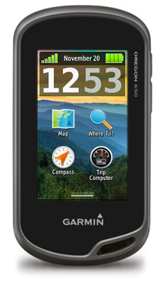
Hands on Garmin Oregon 650 review
On being an early adopter
I am an early adopter. Having owned many Garmin GPS receivers in the past, I find myself eager to experience the new features and functions included with each new hardware release. As many Garmin users are aware, this can mean months of buggy operation while software engineers continue to work out all the kinks in an effort to provide the functionality advertised for each unit.
Related units
- Step up to the Garmin Oregon 650t to get preloaded 1:100,000 scale topo maps for the US
- Or drop down to the Oregon 600 and you’ll give up the 650’s 8MP geotagging camera and internal rechargeable li-ion battery pack (although the latter is available as an add-on option for the 600)
- To see how the Oregon 650 stacks up against other models, check out our Garmin handheld GPS comparison chart
Usually, the software is stable and usable sometime within the first 12 months after release, and at some point much farther away the firmware will be as functional and refined as it will ever be. This is not necessarily a bad thing, as Garmin is very receptive to user input during this period, and I know of no other company that allows for direct user input while refining a product line.
In the past, this reputation has prevented many potential users from adopting Garmin’s newest devices until after they have sufficiently matured. Of course, these late adopters also miss out on being a part of post release development.
With the introduction of the Garmin Oregon 6xx, everything has changed.
A game changer
Garmin has produced several outdoor touch screen GPS receivers. The Oregon x00 series was first, followed by the Oregon x50, Dakota x0 series, and the Montana. Each new release built on the success of the last, offering new features and incremental improvements over previous models.
While Garmin’s newest Oregon 6xx series continues to build on popular features available with past models, this GPSr is far from an incremental or evolutionary step forward. The Oregon 6xx appears to be the first of (what I hope to be) a revolutionary new direction in product philosophy.
The Garmin Oregon 6xx software is very refined and quite mature, right out of the box. The Oregon 6xx is ready to perform, as is.
The Oregon 6xx is a game changer.
The basics
Discussing each and every function of the Oregon 6xx in detail would require more space than is available for this review. For this reason, this review will concentrate mostly on features and improvements new and exclusive to the Oregon 6xx. Detailed information is available at the Garmin Oregon 6xx wiki.
The Oregon 6xx offers the same dual orientation display available with the larger Montana, but lacks the ability to use a powered dock and provide spoken directions. This alone means the Oregon 6xx will not be a viable replacement for most Montana users.
Also carried over from the Montana, the Oregon 6xx allows the user to create one touch shortcuts (macros) allowing quick and easy access to many GPSr features and functions.
Borrowed from the Montana as well is the dual power option, allowing use of standard AA batteries or Garmin’s rechargeable NiMH battery pack that charges inside the GPSr. This feature is standard for Oregon 650/650t, and optional for 600/600t. Only Garmin’s NiMH battery pack can be recharged inside the GPSr.
The Oregon 6xx includes an additional User Button just below the Power Button that can be configured to initiate just about any function desired for single tap, double tap, and hold.
An improved Trip Computer now displays 33% more information on the screen with more data fields available on each page.
The Garmin Oregon 6xx includes 20 additional data field options not available on the Montana.
The Map Applications allows for individual KMZ Custom Maps to be enabled and disabled as desired.
The Oregon 6xx includes a 3-axis electronic compass with accelerometer tilt compensation that can be used in any orientation.
The Oregon 650/650t feature a modern 8MP camera that will take photos you won’t believe came from your GPSr. The included LED flash on these models also serves as a flashlight or emergency strobe beacon, and can be configured to repeatedly flash an S.O.S. signal.
GLONASS support
Originally introduced with the new eTrex series, the Garmin Oregon 6xx can also use GLONASS satellites in addition to standard GPS satellites to achieve quicker position fix times and maintain your fix under heavy cover and in deep canyons. I have yet to test the deep canyon claim, but am very eager to do so later this year when I visit Havasupai, in the depths of the Grand Canyon.
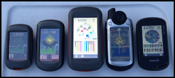
Satellite reception on various Garmin handhelds; Oregon 650 at far right
Some debate exists about whether or not GLONASS improves accuracy. Having more satellites available certainly will improve position acquisition times and help maintain signal lock under heavy cover. My testing suggests the unit is no more accurate with GLONASS turned on than it is with GLONASS turned off. This may not hold true for all locations and environments, and having the option to tap into more satellites when necessary is certainly a benefit I appreciate.
Garmin Oregon 650 screen
Perhaps the most obvious, if not immediately apparent change to the Oregon 6xx series is the new chemically strengthened glass multi-touch display. After using multi-touch smart phones for many years, I found previous Garmin touch screen GPSr units were not exactly intuitive to use. They worked, but never were as precise, or as fluid as I wanted them to be.
The new Oregon 6xx screen looks and behaves much like my iPhone screen. Scrolling menus, making selections, and panning the map screen all function as I expected. I have limited time testing the screen in the wet and with gloves, and have experienced no issues with either.
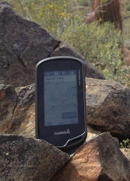
The Garmin Oregon 650 in its natural habitat
The display is very bright, and is as easy to see in direct sunlight as any smart phone. I have absolutely no complaints, and believe this to be the best display Garmin has produced for their outdoor line of GPSr. You will simply have to see the screen for yourself before you can decide.
UPDATE: Here’s a cool screen hardness test!
Wireless capabilities
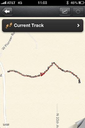
Garmin’s BaseCamp Mobile iOS app
ANT+ has been carried over from previous designs, while Bluetooth has been added to improve data sharing capabilities. Larger files, including KMZ custom maps, photographs, and Adventures can be shared between compatible devices quickly and effortlessly.
iOS users can use BaseCamp Mobile to edit and transfer data between their Oregon 6xx, iOS device, and Garmin cloud storage. I spent some time playing with BaseCamp Mobile, and it functioned reasonably well, but still has plenty of room for improvement. I suspect future improvements and refinements will be coming, and have requested an Android version as well. My iPhone is due for replacement soon, and this time I will not be replacing it with another iOS device.
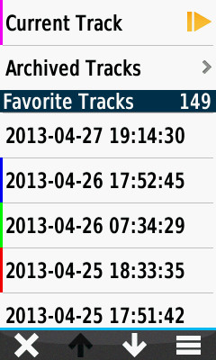
Current track
Debuting on the Oregon 6xx series, the new ‘Current Track’ application greatly improves track log management and workflow.
Gone are the days of having to exit the current application, opening the setup menu, and working through multiple nested option screens to manage your current track log recording options.
Including the ability to create shortcuts (macros) for some common functions on the Montana was a step in the right direction, but many operations still required navigating between applications to view and use all the information available. The Oregon 6xx provides complete track log access and control from one application.
The Current Track application icon (see image below) provides some basic information directly from the main menu screen, before you even open the application. This dynamic icon changes appearance in response to track recording status, displaying a green arrow while track recording is active, and a yellow arrow while paused. The border color of the icon indicates the current track color.
Garmin Oregon 6xx series track icons
The primary interface is divided into four screens, each easily accessed by selecting the appropriate tab along the top of the screen.
The Track Control (shown below at left) screen displays current track color, total time, and total distance. From this screen you can start and pause track recording, delete the current track, and save the current track, in whole or selected portions.
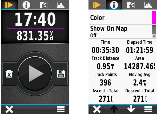
Track control screen shown at left; track information tab shown at right
Select the Track Information tab (shown above at right) to view detailed summary information for the current track, as well as controls to change the current track color, and show or hide the current track on the map screen.
The Map View tab (shown below at left) displays the complete current track on the map screen, providing direct access to a detailed track summary and map screen controls, and the TracBack functions to swap the start/finish points and guide you back the way you came.
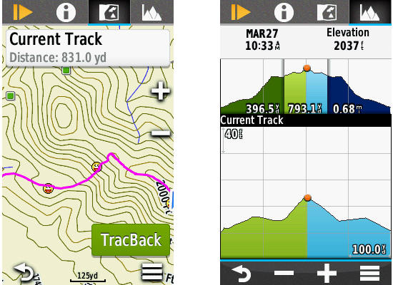
Track map view (left) and elevation (right) tabs
A fourth tab will open the interactive Elevation Plot interface (shown above at right), displaying minimum and maximum elevation information, and allowing the user to view and select any portion of the graph to view specific details. Here you can also see the ‘Future Plot’, an estimate of the track elevation ahead based on installed mapping data. The current track is always displayed in green, and the future plot in blue.
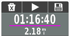
New track control dashboard
A new Track Control dashboard (shown at right) is also provided, allowing essential track log recording control from any application or main menu screen.
Additionally, Garmin has included two new Track Log recording functions: Auto Start, and Auto Pause. Auto Start will initiate Track Log recording each time the Oregon 6xx is powered on and the unit has a satellite lock. Auto Pause will temporarily stop track log recording when you stop moving, and start again when you do. The purpose of this feature is to remove the clutter that occurs in all track recordings each time you stop along the way for any period of time, such as when you stop along a hike to eat lunch.
Here is an example of a short hike with a Montana 650, and Oregon 650 with Auto Pause enabled:
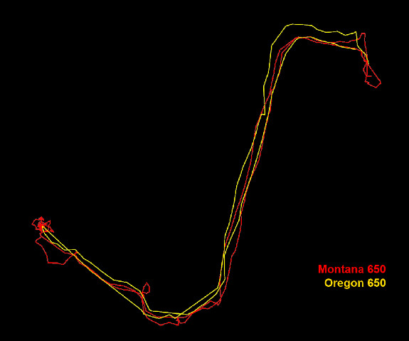
Montana 650 track vs Oregon 650 track with auto pause enabled
Having used the new Current Track interface for the past few weeks, I can’t imagine how Garmin could make track log recording management any more efficient, and I wouldn’t want it any other way.
Garmin Oregon 650 track selection menu
Track manager
The Track Manager application has also been polished and refined, offering more information and streamlined controls for all tracks saved to the Oregon 6xx.
The track selection menu not only provides direct access to all tracks on the device, but also provides track color information for tracks that are currently set to ‘show on map’.
Tracks are displayed based on proximity by default, and can also be sorted alphabetically or by creation date.
A ‘Spell Search’ function is also provided to help users quickly locate a desired track.
Once a track is selected, the user is greeted with a tabbed user interface allowing access to more information and more controls directly from the Track Manager screen.
The Track Information tab (below left) displays statistical data for the selected track, as well as providing controls to edit the track name, change track color, set track visibility on the map, and move the track between favorites and archived status.
The Map View tab (below center) displays the selected track with currently enabled maps, and provides direct access to a Track Summary information page, map controls, and a ‘Go’ button to begin navigating to the selected track.
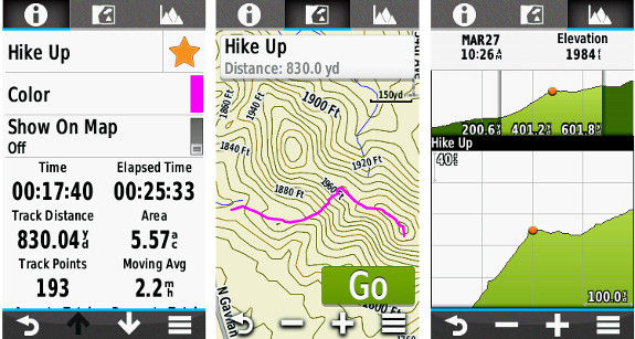
Track info, map and elevation tabs
An Elevation Plot tab (above right) provides detailed elevation information for the selected track. Select any position along the elevation plot, select the menu button, and ‘View on Map’ to view the selected position along the track on the map screen.
The Waypoint Manager application includes similar refinements, offering streamlined editing capabilities not previously available.
Geocaching with the Oregon 650
With all the other added features and refined functionality combined, the Oregon 6xx is already quite desirable, if not impossible to resist. If you are not a geocacher, the Oregon 6xx offers sufficient improvements to merit serious consideration. If you are a geocacher, the Oregon 6xx is the Holy Grail.
For the Oregon 6xx, Garmin has pulled out all the stops and put much effort into building the ultimate caching machine.
No limits. Unlimited. Limitless. These words are fair to use when describing the geocaching capabilities of the Oregon 6xx. Great improvements have been made to both the back end and front end of this device.
Previous paperless geocaching GPSr units were limited by the number of geocaches they could actively index. 2000 for the Colorado, Dakota, and Oregon x00. The Oregon 450/550 series is limited to 5000 caches, and with a 12,000 geocache capacity, the Montana was the best in class. The Oregon 6xx is capable of indexing as many as 4 million geocaches. That is nearly twice the number of geocaches currently available. On the entire planet.
Garmin created a new geocache storage format, GGZ, to help accomplish this, and is making it freely available to any who wish to use it. However, GGZ files are not required to enjoy the virtually unlimited storage capabilities of the Oregon 6xx. You can still load all your PQ’s and GSAK databases to the Oregon 6xx in GPX format, and have all the information for every single geocache available from the new and improved GeoCaching User Interface. Not as POI’s, but as complete geocaches with full descriptions, hints, photos, logs, etc. Every geocache.
The completely re-imagined GCUI also makes use of a now familiar tabbed menu interface with three tabs; Active Geocache, Geocache List, and Geocache Filters.
The Active Geocache menu (below left) provides quick access to the geocache description, photos, logs, hint, chirp details, next stage dialogue, and the geocache logging interface to log your finds.
The Geocache List (below center) displays available geocaches based on your location and enabled filters. Geocaches can be sorted by name and location directly from this screen.
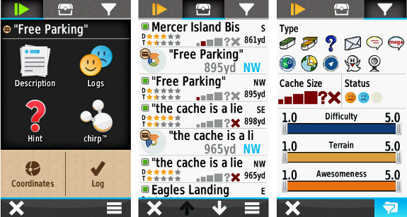
Garmin Oregon 6xx series geocaching screens
The Geocache Filters interface (above right) provides quick and easy filtering controls to decide which geocaches are displayed in the Geocache List as well as on the Map screen. Filter selections are dynamic and applied immediately. Custom filters can be created, saved, and applied instantly as well.
I have been using the new GCUI for several weeks now with more than 50,000 complete geocaches loaded on my Oregon 650, all in GPX format. The Oregon 6xx is still very quick and responsive, even more so than my Montana with only 10,000 geocaches loaded.
Conclusion
After using the new Oregon 650 for nearly eight weeks, I have found the device to be a very capable unit worthy of serious consideration. The Oregon 650 has surpassed nearly all of my expectations, and provided additional features and benefits I wasn’t aware I wanted, and now do not want to be without.
A word of caution, however. Regardless of intended use for this GPSr, be it hiking, riding, geocaching, or whatever, once you’ve used the new features available with the Oregon 6xx, you may just find your other GPSr units collecting dust. A lot of dust.
You will not be disappointed.
More Garmin Oregon 650 reviews
Other Garmin Oregon 650 resources
- The Garmin Oregon 650 owners manual
- Our Garmin handheld GPS comparison cart
- The Garmin Oregon 6xx series wiki
- The official Garmin Oregon 650 web page
Compare prices on the Garmin Oregon 650 at these merchants:
- Check the current Garmin Oregon 650
price at Amazon
- Get the Garmin Oregon 650 at GPS City
- Or buy the Garmin Oregon 650
direct from Garmin

I’ve been using the 650t for geocaching, and have one question. It seems that when I search for caches, it never looks more than 10 miles beyond where I am located. For example, if I have a cache that is more than 100 miles, it will not show up if I search by name. I can go to that cache via the map. but that seemes illogical.Is there a way to extend the search radius of the unit.
Rich
At this time, the Geocache List will only look at about 100 miles from your current location. Any caches beyond that distance will be available from the map view, as you have discovered.
Garmin is considering expanding that distance as the firmware is refined.
I would guess the limited the distance as part of the ability to have unlimited geocaches. It would be nice to be able to look for caches further away using the search by name function.
I’m back from 2 weeks on the east coast. (iPhone maps did a great jog of turn-by-turn navigation through DC, Vermont, NC, and SC, Spot on, every turn, every destination…)
While I was away my ebay special City Navigator 2014 arrived on uSD card. I also have the 24K Topo West on DVD (legal for sure). I previously installed WA and OR Topo maps to the 600. (But I have not idea where they were installed on the internal memory.)
I’ve seen posts about having to rename gmapsupp.img on some Garmin devices. But I recall reading that newer devices don’t require that.
I have a gmapsupp.img in a Garmin2014 folder on the uSD card (drive F:). I have a gmapsupp.img on the Garmin Oregon 600 device (drive I:).
I think what I want to do is put both the 24K Topo and the City Navigator on the uSD card and free up internal ram for waypoints, tracks, routes, screen grabs, etc.
How should I proceed? (Help very much appreciated…)
(How do I point BirdsEye sat images to the uSD card? Or do they need to go in the Garmin\BirdsEye folder on the internal memory?)
Also, I need to get City Navigator into BaseCamp too. I’ve backed up the gmapsupp.img from the uSD card to a real folder on my computer hard drive. What now?
Thanks!
Keith
I see no photos or next stage dialogue in the active geocache menu ? I just have description,logs,hint and chirp
See this… http://gpstracklog.com/2013/06/load-multiple-maps-to-your-garmin-without-renaming-them.html
Why do you want City Navigator and the 24K map? Both have routable roads and POIs.
You’ll need the same file structure on the microSD that you have internally — BirdsEye images need to go in Garmin\BirdsEye on the card.
I’d have to go in and recreate the process to see how to get the maps into BaseCamp. They don’t show up there now under the available maps?
I can’t seem to get my compass to work with waypoints on the Oregon 650. It works great when using it with geocaches but if I try to use it find a waypoint it points to cache instead of the waypoint I’m going to. How can I change to point to where I’m navigating.
First do Where To > Stop Navigation.
Tried it, Rich. No luck. When trying to navigate to a waypoint and then when getting close I try to go compass. All I get is the last geocache I went to and not a compass showing me how far and direction of waypoint
Are you going to the compass page, selecting compass from the main menu? Do you have the geocaching dashboard active on that page?
Having just sold my lovely old 60CSX and bought the 650t, I’m SO disappointed by this Geocaching feature. Even when Geocaching, sometimes I want to navigate to Waypoints, not Geocaches (intermediate points, puzzle solutions or just hastily copied coordinates from my iPhone). If I’m searching for a cache, I can use the map with the Geocaching dashboard to see the compass direction, distance etc. on one screen. I don’t seem able to do that with a Waypoint which my 60csx could do easily. That Geocaching dashboard is stupidly locked to the nearest Geocache even if I’m not navigating to it. It’s crazy! The 650t is sold as the ideal caching tool but partly because that Dashboard is artificially restricted to Geocaches only. If I’m navigating to a Waypoint (no less legitimate than a Geocache) why does the 650t not use the same dashboard over the map to help me?
Mu unit crashes about once a day which I can forgive at this stage but this Waypoint limitation is pretty much a fatal flaw. 🙁
@John F: Why are you complaining that the compass in the Geocaching Dashboard operates as intended?
If you want a standard Compass at the top of the map page, or any other page, simply enable the Compass Dashboard. Takes all of about two seconds.
Perhaps if we spend as much time learning how to use the equipment as we spend complaining about it, we all can enjoy a better result.
http://garminoregon6xx.wikispaces.com/Dashboards+-+Compass
Is it possible that the issue here is the profile?
I don’t know whether the 60CSX had profiles or not but in this, when I am geocaching and navigating by foot I’m in the geocaching profile. I actually created a shortcut on my geocaching profile menu to automative mode and vice versa so that when I am driving I have the nuvi dashboard and turn by turn directions rather than straight line guidance.
When navigating to a non-geocaching waypoint maybe try the recreational or even automotive profile. If those do not suit your needs, I think you can make one of your own but the geocaching profile was made strictly for geocaching but Garmin did make it very easy to switch between different profiles.
Then again, you may have already known that in which case please disregard.
@Atlas Cached: I’m complaining because I can’t find an equivalent alternative to the “locked” Geocache dashboard when searching for a normal Waypoint. The concepts are almost identical – a cache is merely a type of Waypoint – and while they may differ in some details, the usefulness of the map and a combined-purpose “search” dashboard remains legitimate.
Yes, I was fully aware of the Compass dashboard but it’s not the same thing. It’s only a compass, while the Geocache one contains the Geocache (Waypoint) name, a compass pointer and dynamic distance.
Finally, please consider this. If the Geocache dashboard was active for any Waypoint being navigated and Garmin was to suddenly restrict it to just Geocaches, would people be grateful? In my opinion very few would appreciate losing the map/compass/distance combination and gaining the distraction of a nearby (or not-so-nearby) cache. As I wrote, most of us use normal waypoints while Geocaching too. That real-estate could easily be “intended” for both.
@John F:
I am unaware if you are new to Garmin GPSr, but the Geocache Dashboard (for every Garmin GPSr) has always been all about geocaching, and nothing more. That is why it is named the ‘Geocaching Dashboard’. To suggest otherwise is to misunderstand the product.
Now, reading your detailed request, I can inform you that all the information you desire is readily available in dashboard form for use on the map page or any other application by simply enabling the small data fields dashboard with these data fields active:
Pointer: http://garminoregon6xx.wikispaces.com/Data+Fields#x-Data%20Field%20Categories-Pointer
Waypoint At Destination: http://garminoregon6xx.wikispaces.com/Data+Fields#x-Data%20Field%20Categories-Waypoint%20At%20Dest
Distance To Destination: http://garminoregon6xx.wikispaces.com/Data+Fields#x-Data%20Field%20Categories-Distance%20To%20Destination
Compass Heading: http://garminoregon6xx.wikispaces.com/Data+Fields#x-Data%20Field%20Categories-Compass%20Heading
And to answer your other question, I am quite certain that if Garmin were to cripple or otherwise remove functionality from the Geocaching Dashboard as it exists today, the user community response would be overwhelmingly negative. You may not realize this, but the Geocaching Dashboard is not new, and has seen multiple revisions as Garmin engineers continued to develop in direct response to geocachers input over many years.
@Robert Wolfe: your thoughts are helpful because it made me realise that the “small data fields” dashboard with a carefully set-up shortcut might give me something close to the desired outcome in both circumstances. I’ll persevere and see where I get to. Thanks.
@John and others,
I have done almost the same. Sold my 60X and purchased the 650t. My first impressions are quite good, love the large number of caches I can load, the GGZ format from GSAK, the touch screen, the multiple maps, but I have to agree, that walking a Multicache is a bit awkward. The Geocache (GC) dashboard is fine, but only for Tradional like caches. If you need to switch to navigating to a Waypoint, which is common in Multi’s, strangely enough the GC dashboard decides to show the closest GC. Strange… Ok, you can (and honestly need to) switch to the small datafields dashboard, that can be configured to your needs. But then, if you want to read in the GC description what needs to be done at that waypoint, you miss your entrypoint to the GC description: the GC dashboard. In the end there is a lot of switching in profiles, dashboards to accomplish what could be easy if Garmin would combine all available elements in a comprehensive approach.
1. Geocaching dashboard should always be the active Geocache (the one you selected to navigate to); if no Geocache is selected for navigation, it can show the closest, which is quite fun if you drive by car in an area, where geocaches are located.
2. Child waypoints (if available of course) should be listed from the Next Stage button in the Active GC screen, avoiding to need to switch to find Waypoint or entering coords manually. Navigating a (child)waypoint should activate the small datafield dashboard or ideally would have its own dashboard (eg navigate waypoint dashboard) from which you can also get to the waypoint details/description, because they frequently contain instructions/questions to be answered for the waypoint, so you don’t need to go back to the GC description.
I am open for debate and would like to advance this setup to Garmin development team.
By the way, this only applies to text driven Multi’s. As soon as photo’s are part of the puzzles, questions or anyway embedded in GC description, there are some more challenges to become truely paperless, but first things first.
Much obliged,
happy cacher from the Netherlands,
Ton Houwaard
Ton H,
The GC Dashboard allows for navigating multi’s:
http://garminoregon6xx.wikispaces.com/Applications+-+Geocaching#x-Active%20Geocache-Next%20Stage
As for images required for puzzles, etc, that is also possible, with little more effort:
http://garminoregon6xx.wikispaces.com/share/view/62998496
It could be easier, but Groundspeak chooses to prevent you from taking full advantage of all the paperless geocaching features available on the Garmin Oregon 6xx and other GPS devices.
@Atlas,
I am aware of the Next Stage screen, but it seems awkward to manually enter coordinates in the field (for which you need to have a printout with you), while the Geocache has all the child waypoints available. I haven’s figured out yet to embed photo’s into the description, what is required sometimes, rather then have them in a list without the context of the description. Furthermore, photo’s that are embedded in the description are not picked up by MGM software as far as I can see.
Anyway, thanks for your reply. What are your thoughts on my approach for multicaches mentioned in my previous post?
First, not all multi-caches have child waypoints readily available. Most that I have done require me to do some mental math using information available only at the cache location to determine the next stage. For the caches with additional waypoints included, they will be available on your GPSr if you downloaded them with the original GPX.
I have no trouble using MGM to capture each geocache photos, including descriptions, logs, and spoilers.
I am currently working with Garmin to try and make the Next Stage function more functional and user friendly.
Wow, I was edited out of this conversation. I think my work here is done!
Not sure what happened. Nothing got deleted did it? I missed one comment but approved it this morning.
If a comment includes a URL, it is held for moderation. If you ever write another post for GPS Tracklog, we should set you up as an author, which should allow you to post comments without going through the moderation queue.
Thanks for taking the time to repsond to all these BTW. It’s a huge help.
It is there now… When I submitted it last night, it showed to be waiting for moderation, then later it was just simply gone. I checked again a few hours after that and it was still MIA, so I thought It had been moderated out. 🙂
I wondering if anyone else has been having this problem of if maybe I’m doing something wrong. I load a query from GSAK into my Oregon 650. The Query, for example, has 114 caches in it. When I go to my gps not all caches show up. In fact quiet a few don’t show up. I can load the same query into my 76csx and all caches are there. The caches are all within a 10 mile radius. I have my parameters set to show all. I can be standing next to the cache and the 650 doesn’t see it but the 76 will as well as cached queries on my phone. This is extremely frustrating as I’m really like the way the 650 works. Any help would be greatly appreciated.
For some reason Garmin has limited the number of Caches that can be accessed, I think I read somewhere it is within a 100mile radius. If you drag the map you will find all the caches you downloaded are shown.
This happened to me today, I had signed the log of a cache I had just found, I then checked My Oregon 650 for the next nearest and it indicated there was one 1.6km away, set it up and headed in its direction. As we approached it I noticed it had disappeared from the screen, I brought the list up and it was not listed, I checked my found list in case I had tapped that in error, but it was not listed. I did a reset by removing and replacing the batteries no luck.
Any suggestion as to what may have happened.
I had something similar happen tonight as well. I was out geocaching, found one cache, and knew there was another one close by of the same series. I know that I’d loaded it on to my 650t, but I could not find it anywhere. I was able to get close to it with my iPhone, and I entered the coords into my Oregon. When I got to GZ, I looked at it, and, lo and behold, that cache now appeared on my geocache pages. I’m not sure what the software is doing with regards to how it determines what is and isn’t displayed, but I would think that distance the most important factor, and it should show all the caches.
Please See BUGS 33-36:
http://garminoregon6xx.wikispaces.com/Common+Issues$Bug%2033
Wish I could edit my post 🙁
http://garminoregon6xx.wikispaces.com/Common+Issues#Bug%2033
I can set you up as an author to do that if you want, but it will have to wait till next week. Thanks again for responding to comments here. My Oregon 600 review should finally be posted soon, hopefully Monday.
The caches in question were not ones listed under 33-36. They were traditional micros (GC3BN29 was one of them). What was so strange was that it showed other caches of all types that were further away than these two. Had I not known they were there (I knew the cache owner), I would have missed them entirely.
I senf that cache to both my Oregon 6xx units, and neither had any issue showing it on the map or in the list view. No idea why you were having trouble. 🙁
The cache that I was referring to was loaded as part of a pocket query, not a stand alone cache. I’ve noticed more and more that when I look at my GPS for a cache, it’s not always showing the everyone within the selected map size I’m using. The one I was telling you about didn’t show up until I was right next to it. Then the icon appreared when I looked at the map. I only knew it was there because I knew it had been placed there.
This I what I experienced a month ago while I was on vacation. I had loaded local caches, well within the 100 mile restriction set by garmin(why? I would rather see them on my list that to try to find them on a map )and had caches not show up on the cache list.
I did a complete reset ,several times ,did the time consuming process of resetting my preferences and that problem has minimized.
Continuing on the subject of missing caches, yesterday I received a notification of a cache had been replaced and no longer archived so I decided to load it into my 650 with a list of other caches. When I checked it did not show in the list, After repeated tries I had to do a reset of the unit by removing the Batts. which solved the problem.
With my old 450 when plugged into the PC and running BaseCamp the loaded caches would show, is there anyway when I plug in the 650 I can get the loaded caches show in BaseCamp.
What type of cache was it? Did it fall under any listed in the bugs I posted a link to above?
It was a traditional Cache.
I have always assumed that the files I created were downloaded completely, my normal practice is to create one file for the Gps and one for the BaseCamp, the one for BaseCamp did show the missing Cache so what I am doing now is importing The BaseCamp file to the Gps. The file that was created for BaseCamp is a .GPX and the one created for the Gps (by GSAK) is a .ggz file. My next question is when BaseCamp sends the Cache file to my Gps does it convert it to the new Garmin .ggz.
Where I live “Opencaching.com” shows 38 caches for my area code, “Geocaching.com” for the same area code shows 350.
Why in BaseCamp and the 650 instruction book does Garmin want us to refer to Opencaching.com, is there any advantage?
The best reason for that is Gramin had a falling out with Groundspeak (for whatever reason), and started Opencaching as a viable option. I think as a viable option, it fell flat on it’s face, obvioulsy look at the numbers. They probably refer to opencaching as a self-serving measure.
Hello Rich,
can you explain me better in recorded data reset what track and trip function do?
Thank you
I’m not sure exactly what you’re asking, but this may help re: tracks… http://gpstracklog.com/2010/03/handheld-gps-101-tracks.html
In “recorded data reset” of garmin oregon i have two option to choose:
1) track anda trip
2) on request
i have choosen the second one (on request) beacuse i dont understand what “track and trip” do…
sorry for my bad english)
Sorry, I’m not sure. Those settings aren’t shown on the US firmware. I’m assuming that track and trip clears the tracklog and resets all trip data.
ok Rich, thank you!
Rich is correct, ‘Track and Trip’ will reset both track log and trip computer data when the Current Track is cleared.
More info here:
http://garminoregon6xx.wikispaces.com/Setup+-+Tracks#Advanced%20Setup-Recorded%20Data%20Reset
http://garminoregon6xx.wikispaces.com/Applications+-+Current+Track#x-Current%20Track%20Control-Save%20Track%20Recording-Data%20Reset
Hello Rich,
i have another question (i hope last 🙂 )
when i upload new atctivities on garmin connect, all data are uploaded correctly
just one thing is always unknown (see http://d.pr/i/JEkP)
it seem it doesnt recognize the device.
any option i need to check?
someone has the same problem?
let me know
thank you
You might want to ask here: https://forums.garmin.com/forumdisplay.php?30-Garmin-Connect
thank you Rich
Hello!
I used to find geocaches with Garmin 60Sx, but it was broken and I needed a new gps. Now I’m in trouble with it. I’m a woman and don’t know anything about booting or rebooting or something similar, also I did not learn English, I hope somebody can understand and help me!
I have a new Garmin Oregon 650 and I can’t open the active geocache tab. If I chose this tab, Oregon asks to choose a geocache, when I choose the geocache, it jumps to the map, and if I go back to active geocache tab, the answer is again.the same.
I put the geocaches in my gps with Basecamp or by one from the geocaching com, but nothing worked.
Also I can’t log finds.
What could be wrong?
Marx
When you select a geocache from the Geocache List, and the map screen appears, you must select [Go] – then the selected geocache will be displayed in the Active Geocache Tab.
Thanks!
The problem was, I guess, that I did try to log finds at my home and the gps did not find the satellites, so nothing worked.
How does this unit’s touchscreen perform in the rain? How about with wet hands?
Like most other digital devices, Garmin’s handheld GPSr models with touchscreens really don’t like to be wet. On mine, drops of water on the screen or drippy-wet hands will cause problems. If my Oregon 600 is exposed to water, I usually have to dry my hands and wipe the screen dry before I can use the device. Always remember that Garmin’s handhelds are only “water resistant”, not waterproof. The battery hatch o-ring will probably prevent water intrusion in a brief, light rainshower, at least while the unit is a year old or less and the o-ring is is good shape, but I would not expose any Garmin handheld to a really heavy downpour. If even a tiny amount of water got past the battery hatch seal, it could ruin the unit, as the SD card connector and the motherboard are both exposed right under the batteries. Also, NEVER store your Garmin handheld with the batteries in it for more than a few days; if you know that you won’t be using the device for an extended period, pull the batteries out! If the batteries ever leak, which often happens to old “AA”‘s that are discharged, the leaking chemicals will likely destroy the SD card connector and the motherboard. This happened to a Garmin 60CSX that belonged to a friend of mine.
“Always remember that Garmin’s handhelds are only “water resistant”, not waterproof.”
Garmin’s website for the 600 series states: “The new rugged and waterproof GPS Oregon series” “Bumps, dust, dirt, humidity and water are no match for this mapping-oriented navigator.” The IPX7 rating means “Withstands incidental exposure to water of up to 1 meter for up to 30 minutes” and “Indoor/outdoor use in the presence of rain, snow or brief splashes of water”
You might want to read this, including the comments… http://gpstracklog.com/2014/02/geocaching-gps-field-test.html
My goal is to take waypoints in the field, take a photo at the waypoint, and import the data into ArcMap with photo file as an attribute or associated file. I have been associating photos with waypoints in situ. To retrieve file, I copy/paste waypoint file (one gpx file with the day’s points) from GPS to hard drive. From here, I can’t find a database that includes the photo.
Does anyone know how to effectively like a waypoint to a photo and transfer it to another program? Any help is much appreciated.
My goal is to take waypoints in the field, take a photo at the waypoint, and import the data into ArcMap with photo file as an attribute or associated file. I have been associating photos with waypoints (in situ). To retrieve file, I copy/paste waypoint file (one gpx file with the day’s points) from GPS to hard drive. From here, I can’t find a database that includes the photo.
Does anyone know how to effectively like a waypoint to a photo and transfer it to another program? Any help is much appreciated.
Measurement Error.
I am trying to obtain information on the measurement error for the Garmin 600. No one seems to discuss this. For today, I carried my Garmin “off” to my back yard and placed it in the grass. There I turned it on, deleted the current log, started a new log, and (leaving the Garmin in the grass) I went back in the house for 15 min.
On returning, without picking the garmin up, I looked at the various pages of “current track” available on the 600. Here is what I found.
Distance: 173 ft
Minimum Altitude: 332 ft
Maximum Altitude: 345 ft.
I then turned it off. Picked it up, back inside, connected to my computer, booted up Basecamp, and imported that file.
Basecamp reports that while on my lawn the 600 ascended 5 ft, descended 1 ft, and traveled a distance of 181 ft. I asked my wife (who had been sitting near the back window the entire time) whether she had noted all of this zooming back and forth, but apparently she was too busy knitting to glance out the window.
So here is the thing. According to my 600, yesterday I took a 11 hr 10 min hike in the Adirondacks during which I traveled 20.01 miles and ascended 4,206 feet.
I am pretty sure that the time is accurate (as it matches both my wristwatch and the car clock), but how far did I really walk? and how many feet did I really climb?
I had exactly the same behaviour with my 650t. The unit I had earlier also had big issues in regards to GPS accuracy. I had it replaced a while back due to screen issues as well. The unit I have now is performing better, but if the unit is stationary it keeps recording speed, tracks etc. I imagine this does not happen when you are in motion and tracks might be quite accurate, but if for instance you take a break during a long hike the overall distance might be quite off. I mostly use the 650t for geocaching and I have stopped recording tracks long ago. Wonder is this is an big and well known issue at the manufacturer.
To answer your question about Measurement Error, I will briefly describe how GPS
works, and why it is not possible for measurements to be perfectly accurate. GPS
consists of three components: (1.) The Satellites orbiting the earth, (2.) The
Master Control Station and Ground Tracking Stations, and (3) The Users with their
GPS receivers. How it works is this:
1. The Satellites have radio transmitters, Atomic Clocks, and computers in them,
that broadcast a set of digital coded signals called the C/A Code and the P/Y code.
The C/A, or Coase Aquisition Code, is a stream of binary digits, 1 million per
second, that repeats every seven minutes and that starts and ends at extremely
precise time ticks generated by those Atomic clocks on each satellite. The exact
sequence of the C/A code is unique for each satellite, which is how your GPSr knows
which satellite it’s listening to on a given channel. The P/Y code is 10 million
bits per second and it repeats once per week. Due to the much greater amount of
processing power needed to process the P/Y code, most civilian GPS receivers use
only the C/A code. Some Survey-grade receivers use the P/Y code, but these are
devices than cost close to $25,000, so you can see why recreational GPS like your
Oregon 600 doesn’t use the P/Y code. From the viewpoint of the User, the main
difference between them is accuracy: the 1 megabit per second C/A Code, when divided
by the speed of light of the radio transmission, gives a maximum “resolution” of ±30
feet. The P/Y code, with 10 times more data, can be resolved into about a ±3-foot
error.
2. The Control stations on the ground are tasked with tracking the satellites,
computing the tiny changes in their orbits due to atmospheric drag, solar wind,
gravity fluctuations from the sun, moon, and other planets, and then uploading these
orbital corrections back to each satellite. This data is the satellite’s
“ephemeris”, a mathematical model that describes where the satellite should be in
it’s orbit at any given moment, and the speed and direction vectors that describe to
the GPS receivers how to predict where the satellite will be for the next seconds,
minutes, etc. of the observation. All of this data is broadcast by each satellite
along with the C/A and P/Y codes and the precice time ticks. This is why it can take
up to 7 minutes for your Garmin to “initialize” if it has been powered off for
several months or moved a long distance with the power off; it has to wait for the
satellites to download all this data, which may take up to 7 minutes.
3. The GPS Receivers (the User Segment). Your Oregon 600 has built into the follwing
components and systems: (a) a munti-channel radio receiver that is tuned to 1575
megahertz, which is the primary frequency that the satellites broadcast on. (b) a
datastore in firmware memory that contains a record of the unique C/A Code Sequence
for each satellite, and the exact time for each satellite that each chunk of code is
supposed to begin and end. (c) a Quartz clock with which to compare the time lag
between when the code sequence was supposed to have left the satellite and when it
was received. (d) Other data related to the “shape” of the Earth and the various
“datums” around which geographical mapping has been created, like the WGS 84 Datum,
or the NAD 27 Datum.
Okay, so let’s say your Oregon 600 has found and locked onto the radio broadcast
from 15 satellites, 9 of them American ones, and the rest Russian GLONASS birds.
These space vehicles are going to be a minimum of about 12,000 miles away, for one
directly overhead; satellites on the horizon will be further away. Your Oregon will
listen to few milliseconds of C/A code from a given satellite, and then look for a
matching segment of code in it’s datastore. Once it finds a match, it will compute
the time difference between when that segment of code was supposed to have left the
satellite and when it was received. This time difference, multiplied by the speed of
light, gives the preliminary distance in a strait line between the antennas on the
satellite and the reciver. Your Oregon 600 then processes the same data from the
other 11 satellites it’s listening to. It does this continously, performing
thousands of computations each second. Next, it takes this set of linear distances
it’s computed, and starts comparing them against the ephemerides of the satellites,
and comparing THAT against a mathematical model of the Earth’s surface, called the
“GRS80 Ellipsoid”. With all of this data in hand, your Oregon 600 will map out a set
of 12 circles on the surface of the GRS80 Ellipsoid on which the distances it’s
computed to the 12 satellites “fits”. Where those 12 circles intersect is where the
Oregon 600 is. Okay so far? Now, I will explain where the errors come in.
1. Atmosperic Effects. The Satellites are broadcasting at 1575 megahertz, and as
these microwave radio signals punch down to your Oregon 600 through the atmosphere,
they are distorted a little by the different layers of gas, trapped electromagnetic
radiation (the Van Allen Belts), the Solar Wind, and even the Earth’s gravity.
Because the environment is dynamic – i.e. the atmosphere is constantly changing in
temperature, density, and composition – it’s not possible to program a small
handheld GPS with a precise Ionospheric correction factor that works everywhere and
all the time. Survey Grade receivers can compute Ionospheric correction factors in
real time, but you pay dearly (like $20,000+ for a Trimble R8) for the capability.
2. Uncertainty in the ephemeris. It is not possible for the satellites to know
exactly where they are in their orbits or exactly what their trajectory vectors are
at every instant of time. There is always going to be some amount of drift and
imprecision.
3. The Quartz clock in your $400 Oregon 600 is several orders of magnitude less
precise than the Atomic clocks in the $600 million NAVSTAR Satellites. This small
difference in precision is enough to introduce some additional uncertainty in the
Receiver-to-Satellite Range computation.
4. The C/A Code itself is a binary code, with each “bit” beginning and ending at
time ticks 1/2,000,000 second apart. In that amount of time, the radio wave itself
will have moved 492 feet. Additional processing can be done to increase accuracy of
the range computation, for example Carrier Phase Angle Detection, but such
computations place a heavy cost in terms of the retail price of the unit, and the
amount of battery power required to run the more powerful processor.
5. Multipath error: The radio waves coming from the satellites reflect from the
ground, nearby objects like road signs, motor vehicles, buildings, and tree leaves.
These reflections can introduce errors.
6. Dilution of Precision, or DOP. There are several kinds of DOP, the most
important probably being PDOP, or Positional Dilution of Precision. This comes into
play when the visible satellites your Oregon 600 is tracking happen to be bunched
together in one part of the sky, like if you are hiking in the Grand Canyon, all the
satellites will be more or less directly overhead with none lower in the sky near
the Horizon. The more they’re clustered together, the worse the problem. For
maximum precision in computation of those range circles discussed above, you want
the satellites ideally to be spread out all over the sky, with one or two directly
overhead (gives the best Elevation), several scattered all around the sky at about
10º~15º above the horizon, and the rest scattered all around between the horizon and
the zenith. Also keep in mind that your GPSr can ONLY see those satellites that are
above the horizon – obviously it can’t see satellites through the earth’s mass on
the “other” side of the sky. This is fundamentally why Horizontal positioning is
more accurate on all GPSr’s than Vertical, and why the Elevation numbers on your
Oregon 600 fluctutate a lot more than the Latitude and Longitude.
The bottom line is that these six kinds of errors and uncertainties are inherant in
any model of GPS, and especially in recreational units that have very small antennae
and low powered processors that use only the C/A code. Under IDEAL conditions, your
Horizontal Probability of Position is a circle with at least 10 feet of radius, and
more likely 15 feet. Vertical accuracy will be 30’~40’±. Survey Grade receivers
that can use the P/Y Code have a Horizontal accuracy limited to maybe a 2’~3′ radius
circle. To do actual land surveying, these receivers don’t even use the codes: they
perform their satellite range computation based on detecting the actual “carrier
phase angle”, accurate to 1/360 of a wavelength, of that 1575 megahertz radio signal
hitting the antenna at an instant in time. This allows theoretical range precision
to 0.6mm, but in the real world, 3mm to 5mm is what we expect from a $30,000 Trimble
R7 survey grade receiver with a Zephyr Geodetic antenna (the antenna alone, a large
round disc the size of a big dinner plate, costs $10,000 new). In order to keep
recreational GPS’s under a few hundred dollars in price, and able to operate for at
least 12 hours on “AA” batteries, I don’t think it’s possible to boost their
precision significantly, and the Government (Military) already has concerns over the
possibility of enhanced precision in recreation grade GPS’s, which is why the P/Y
code is encrypted and only very expensive Survey grade and Military-only recievers
are capable of reading it.
I know this was kind of long-winded, but I hope it gives you a fairly comprehensive
idea of why your Oregon 600 can’t ever seem to “settle down” and show stable
coordinates and elevations, even when you set it down somewhere with a totally clear
view of the sky.
That was AWESOME!!!
Fantastic presentation of information, thank you!!
First of all this is a Great site. Thanks. Question; I am looking at the Oregon 650 for purchase. I checked the firmware at the store and is version 2.70. I know the latest Firmware is 4.10. Should I look around to get a unit closer to the firmware 4.10 or just buy and perform an update? If I do a massive update will it eat into the internal memory?
Thank You
It would probably be easier to purchase one with a closer firmware just so you don’t have a much of an update to do. However, as the unit does have an microSD card, using up a little more memory shouldn’t be an issue as you can always expand the memory as needed. It just depends on how much fiddling you want to do and what the price difference is. If it’s comparable, I’d go with a more updated version for simplicity’s sake.
I agree with getting the most recent firmware available is a good thing. Part of the problem with getting a unit that has the most updated firmware is finding a store that will let you open the product and turn it on to see. The 600 series is being shipped in those plastic box type holders that are difficult to open and close. I got the 650t when it was released, and have had no problem with any of the updates to the one I’ve had.
First of all this is a Great site. Thanks. Question; I am looking at the Oregon 650 for purchase. I checked the firmware at the store and is version 2.70. I know the latest Firmware is 4.10. Should I look around to get a unit closer to the firmware 4.10 or just buy and perform an update? If I do a massive update will it eat into the internal memory?
Thank You
I wasn’t aware that there was an update to 4.10. The new Garmin Express keeps telling me I have the latest version. But when I went to My Garmin, it said I should update. I don’t think you’ll find a device in any store with the most current version of firmware. They all most like ship with the version that is available when it was built. There should be no problem doing an update for the device. I’ve done several of them and they’ve installed with no problems.
Version 4.10 was available July 2. Try this link:
http://www8.garmin.com/support/download_details.jsp?id=6157
I understand you will not get the latest Version on a new unit, but I would think that I should be able to find a device that is more recent than version 2.7, which is about a year old.
I don’t think you’ll find out what version is on a unit that is for sale unless you open the box and turn it on. I would be surprised if you found one with anything newer than what you’ve found. Here is a link to the firmware versions that it’s had made: http://garminoregon6xx.wikispaces.com/Firmware
I think mine shipped with 2.7. You also contact Garmin and see what the units they sell are shipping with.
Purchased a Oregon 650 unit from Cabelas, had version 2,7 firmware. Found a better price online another retailer, so I returned unit to Cabelas (would not price match BestBuy). My new unit just arrived has version 3.8 firmware. Also, noted it has a liitle more free space available in internal memory than previous unit.
Performed update to 4.1 firmware; no problems. All is good.
As for the update, the Garmin Express does not do a good job at informing users of updates to either maps or firmware. I have to go to my.garmin.com to get the latest information.
Just received my new Oregon 650. Following instructions during setup I tried to select what type of Battery I was using. Had the provided Garmin rechargable battery pack in. There was no display for Battery Type. Renoved Garmin Battery pack and installed AA Alkaline; then the Battery Type select did display. Is this normal?? Thanks
This is normal. The unit can tell when the Garmin Battery Pack is installed and only gives the battery type option when another battery is installed.
I am trying to decide on a new gps and have some questions… When moving pocket queries to the device, do they show up under the open caching icon? Also, after logging a cache as found on the device, how does this information get to the website?
Hi,
i have this issue…
when i follow a track i usually use the zoom buttons but i always click on map, adding waypoints (red pin) into map that i have to delete and with gloves is hard…
there is a way to disable temporary the chance to add pins on map?
thank you
This has been a most interesting read. The full and extensive review by Andy Byers was terrific and the many many responses that followed has had me spell bound.
I too have a question though. It is a repeat of one that has been mentioned before, but I am still no wiser for it.
I bought a 650 four weeks ago, but have had an ongoing problem with it from new. Tens of emails to Garmin Customer support resulted in them concluding that the device was faulty, so yesterday it was exchanged, but I still get the same fault! The fault, as listed by others in this thread is that when I download a PQ from GSAK onto the device, it does not list them all. When I download the same PQ onto my Oregon 300 it lists all of them. With a bigger memory it should load everything, surely? My PQ has 1000 caches, in a radius of 100 miles. Some caches are not downloaded, even though they are only 15 miles away. It means i would set off with a GPS carrying some, but not all geocaches. With my old 300 model (which still works) I go off caching with a full listing of all my 1000 caches in the PQ.
Garmin said there must be a fault. The exchanged unit does the same thing. Previous people in the thread above have found the same thing. I am in a position where I can return my device to the store for a full money back refund and I am considering this, despite the glowing review at the top of the page. What can be done (if anything) to download caches as efficiently as the 300? Do they still sell a 300? it would seem a better buy. If not, does the 400 or 500 download all of a PQ.?
Has anyone successfully downloaded a complete PQ on a 650? If so, then perhaps my device is faulty again? Lots of questions, I know, but I am desperate for an answer before my two week window of opportunity for a refund will close. Many thanks in anticipation of advice from anyone out there!
I’ve used Garmin GPSr devices for over 6 years, starting with the Oregon 300. I’ve used a 400, 450t, 550, 550t, 650t and GPSMap 64s(my current one). Up until the 600 series/64 series, all the devices had a limitation on the number of geocaches they could hold. I think it was 5000. With the newer ones, there is no limit to the amount of caches they can contain. My 64s currently has 65 PQs on it, and all caches show up. I load all of my PQs directly, not through GSAK. That may be part of the problem. Also the newer GPSrs, for some reason, limit the distance they search from. I think it’s a 30 mile radius from where the device is. So even though I have thousands of caches on my GPSr, it will only search/show those that are within 30 miles. When the devices were first released, this was a major sticking point, and they may have reduced it to 15. As for keeping a 300, I’ve still got my 550 but only for Wherigo caches. The newer ones don’t support those caches. I use both the 650t and 64s, but mostly the 64s. I have a feeling, from the way you describe your issue, it may be an issue with the distance limitation.
Hi Rich. Thank you for your very quick and very helpful response. I much appreciate it. Clearly you are well versed with all the Garmin devices! I will try loading the PQ directly (via geocaching.com?) rather than use GSAK, although the 300 was always happy with GSAK.
One question though: If you have all those PQ’s on your device, and therefore thousands of geocaches, but the distance limitation prevents you from seeing any of them, does your device show a geocache when you get nearer to it? Eg, i load 1000 caches. It does not show a particular cache that is, say, 16.5 miles away. Searching for it by name reveals nothing either, so it appears it has not been downloaded. If I then drive to within, say 5 miles of where the cache is, will it then show itself on the GPS via a name search and/or list of nearest caches?
The PQs I have on my 650t and 64s are for all over the country. I live in Portland OR, but have PQs for southern California, some in the midwest and east coast. The way I can see them is to go to the map on the device, and then select the area that I want to view. For example, if I want to see my PQ caches around Disneyland, I would have to use the map to select that area, and zoom in. When I do, the caches show up, with all the information that is needed to find them. I think limiting the search area was a trade off in allowing the number of caches/waypoints to be increased on the newer devices. I found this out when I got my 650t, and almost returned it because of that. But I rarely have a need to search for caches beyond 30 miles, so I’ve just lived with it, since the older units limit the number of caches on them. It might be a good question to run by Garmin the next time you talk to them.
Thanks again Rich. Most helpful. Once or twice, but very seldom, I would download a PQ on my 300 and when out geocaching I would find that the PQ had not downloaded properly for some reason, so I was left high and dry with now geocaches to find. Consequently, my habit now is to download a PQ and then do a random search (by name) on the GPS for one or two caches, to ensure that they are downloaded properly. If they are, off I go.
This is how I discovered that some caches on the 650 had not downloaded. So, if I set off on a drive, some 20 miles away, to do some geocaching, will the caches then show up, even though they don’t when I am at home? That is the burning question! Thanks
In theory they should. When we went to southern California in August, all the caches I had for down there showed up, but nothing in Oregon. Today, if I fire up my 650t or 64s, it will show caches around Portland, but not in southern California. And I have both PQs on my device all the time. I have them scheduled to update weekly, and I usually reload on Fridays so I have the most recent ones on them.That is what I like about the newer ones, unlimited PQs/caches. The only limitation is that I can only schedule 70 (10 per day) to run on Groundspeak……
My Oregon 600 has several quirks that I am certain are program code errors in the operating system firmware, or examples of program code in which the “software” isn’t fully compatible with the “hardware”. I doubt that Garmin’s software development team writes program code from scratch, fully customized for every model; they almost certainly take the high-level hardware drivers and firmware code already written for a previous model and try to adapt it to the particular hardware of the new model under development. Nobody “re-invents the wheel” from scratch in a consumer product line if there is a way to re-use existing software. It’s just that doing software development this way inevitably introduces glitches and “quirks” from mixing old program code written to drive old hardware, with newer hardware that isn’t 100% the same. The Oregon series has had a troubled history of firmware updates, many more than the 60C series did during it’s production and service life; I wonder if part of this is due to the change from the NAVSTAR-only SirfStar III chipset in the 60C series to the GLONASS-enabled Oregon series, and also the introduction of touchscreen technology. The Oregon’ selectronic “guts” are vastly different from the previous generation of Garmin handhelds like the 60C and E-Trex models that weren’t touch screens. Just compare the user menus on a 60Cx and an Oregon; they’re so completely different, you’d think the Oregon isn’t even a Garmin product.
Thanks Larry Charlot and Rich.
Very helpful responses, I am grateful. Today has been a steep learning curve. I have created many PQ’s based on my locality and areas I often drive to. However, on loading all 8 PQ’s to my GPS from the computer, only the last one appears to be there. (and that is Southampton, some 100 miles away, but local ones to my house aren’t there). This is because Southampton was the last PQ to be loaded. I thought they would all load, one after the other, but it seems each one I loaded has over-written the previous one. How do I get multiple PQ’s on the 650? Any ideas? I google search has not revealed the answer to me yet!
How are you loading your PQs onto your device? The way I do it is to download all my PQs to folder on my PC. I then unzip them, which places them in a folder for each one. I connect my GPSr to my computer, where it shows up as a disc drive. I open it up in a second window. Geocaches are kept in the Garmin/GPS folder. I copy all the PQs there by dragging and dropping them into that folder. When I disconnect the GPSr, it has to be turned on so the map database can be updated. It will show a green progress bar across the bottom of the screen. When it’s finished, it will display the normal start up screen.
Hi Rich. At last I think I am there! It took a while because placing the unzipped pocket queries into the GPS folder on the device did not work. I tried moving them to the GGZ folder but that too did not work. Then I tried the GPX folder and all was well. (The unzipped files were .gpx files, so I guess it made sense to drop them into that folder). I now have 8 PQ’s in the folder, but just the local one to my house showing. Tomorrow I shall drive off to another area and see if different geocaches pop up from one of the other PQ’s installed. Many thanks for all your advice. I did read somewhere (and I cant remember where) that when searching for a particular cache, the GPS will give details of past logs, hints, description and photos. I can access all the data to do with the cache except for any photos/spoilers that are in the cache gallery. Did I dream it, or should I be able to access the photos too? Sorry to throw another question at you!
Thanks. Alan
My error on the last email, it should have been the /GPX folder. The GGZ folder is where Garmin stores files that are in a different format. My 64s came preloaded with 250,000 caches, and that is where they kept that file. Yup, all those caches in one file.
No you won’t be able to view photos in a PQ on a GPSr. They also only download only the last 5 logs. One reason I always have my iPhone with me.
Hi GPS guru’s 🙂
I want to buy a suitable Garmin GPS for finding my way on tracks with my Enduro motorbike. this includes existinmg paths, but also some times we need to navigate pre-recorded tracks in so called extreme enduro’s in pretty rugged terrain (if you are interested in what this is, just visit http://www.redbullromaniacs.com). So i have no appetite for geocaching or such things. another usage is if i am with my bike abroad on holiday and try to find some tracks myself, then i need a good view of a detailed map on my gps to follow existing small hiking and biking tracks. At the moment i am using an older model GPSmap60Cx to just try the garmin navigatioon, i have downloaded some detailed maps from Garmin.OpenStreetMap and these maps are having good detail and many small tracks, but when i have installed them on the GPS, i am not impressed by the screen and the way i can view tracks, just slightly too small it seems. So i was considering buying a new touchscreen model, the Montana looks like it is a great device, but is too big for enduro-bike-mount (also consider impact when crashing, so it needs a very specific mounting, almost below handlebars), so it looked to me the Oregon 650 is a good fit for this purpose. since it has better and slightly bigger screen it seems… But i also found some comments on this review page for the Oregon 650 that it may have some glitches and is not always very responsive while navigating tracks…? Now that would be a problem, since with an enduro bike in such track-based race, you are depending on this heavily for proper response on tracks while you ride between ~5-45 KM/Hour. Would you still consider this to be a good device for my purpose, or would you recommend another model? Pls share all relevant comments… pro’s and con’s… Thanks in Advance, Wopke from Netherlands.
If the Montana is too large for your your intended mounting location, then any of the Oregon models would probably be your next best choice. But, the screen on the Oregon is not very much larger than the screen on the 60CX that you tested. I have both a 60CX and an Oregon 600 myself, so I know both devices well. I often wish my Oregon screen was larger when I am using it in my car. As a GPS for hiking or geocaching, it’s great: when walking around with it, I don’t need a huge screen. But when driving a motor vehicle and trying to navigate with it, the screen really is too small. There a good reason that purpose-built car navigation units like the Nuvi, Street Pilot, and TomTom are so much larger than the Oregon and 60~62 series Garmin handheld units. With the vibration of a moving motor vehicle, it’s just too hard to see what you are trying to see on such a tiny screen. I suggest you re-consider the Montana, or even the Monterra, which is an Android based device like a ruggedized smartphone, and might therefore be more versatile.