Sunday, March 18, 2012

Topo maps on Google Maps

Two websites integrating topo maps with Google Maps recently came to my attention. The first is Topographs.com, which I discovered via Groundspeak. The other is BackcountryMaps.com, found via Google Maps Mania. I haven’t had a lot of time to explore these, but these are my initial impressions:

Topographs allows you to add GPS tracks, though not directly. But it is SLOW. At least it is on my computer. BackcountryMaps is faster, but there appears to be no GPS interface.

Related posts:

Technorati tags: GPS, Google Maps, topo
Points of Interest (POIs) resources

Last updated February 19, 2008

This thread originally dealt solely with custom points of interest
(POIs), but I’ve updated and reorganized it to include online sources
of POIs, conversion tools and more.

Custom points of interest (POI) resources

read more

How are Garmin and Magellan topo maps different?

Over at Groundspeak, Geocaching.com‘s message forum, Peter gave a great explanation of the differences between Garmin and Magellan topo maps:

"As Sputnik indicated, the approaches taken by Magellan and Garmin are different. Garmin uses Digital Raster Graphics (DRG) to basically create an image of the USGS 1:100,000 series maps. Therefore their maps have all the detail and accuracy provided by those maps, and nothing else – which means they lack most road names and anything built since the maps were last updated (20 years or so ago in many areas). But they do show the features included by the USGS: springs, fire roads, quite a few trails, etc. Also note that the 1:100,000 maps are metric so the contour spacings are based on rounded numbers of meters. When your GPS is set to feet the spacings look a bit strange (e.g. contours at 164′, 328′, 492′, etc.)

Magellan’s topo maps are instead based on the Digital Elevation Model (DEM) technology where elevations are sampled in a grid pattern and the contour lines are then recreated by interpolation between grid points. That provides the contour line detail but by itself wouldn’t give you anything else. So Magellan combines this topology data with the same road data they use for their street maps (based on TIGER for the original Streets and Topo programs, based on NavTeq for DirectRoute and 3DTopo).

If you want to get by on just a single set of maps then Magellan’s approach is clearly superior. But anyone who wants auto-routing and elevation data (both good things to have) will need to get both sets of maps anyway. In that case each approach has its good and bad sides. Magellan lets you see all the data at one time on your screen since their street data is identical on both and therefore doesn’t cause a problem, but they lack many of the older dirt roads and trails that are included on the old USGS maps used by Garmin. And, as Sputnik said, you can load both sets of maps in your Garmin and toggle between them. I frequently use CitySelect to get to a trailhead and then switch to Topo to see the terrain and trails for a hike."


Theme park maps for your Garmin GPS

Stonemaps offers GPS maps for theme parks including Disney World and Disneyland. They also have some maps for Utah ski resorts, and for other theme parks in California and Florida. Sorry, no Magellan maps yet. Found via Groundspeak.

Related posts:

Technorati tags: GPS, Disney World, Disneyland

Waypoint Averaging

Mobile Crossing did a piece the other day on waypoint averaging (see their February 7, 2006 entry), and it struck me that many readers might not know about this.  The idea is that your GPS may only be  delivering an accuracy of a certain number of feet, but if your GPS can take multiple readings and average them, you can get more accurate waypoint placement.

Many receivers, including my Garmin 60CS, have this function built into them. You can set your GPS down at a trail junction and let it take a number of readings. The UseNet group sci.geo.satellite-nav elaborated on this in a recent thread, discussing doing waypoint averaging across multiple outings and the use of GarTrip software to properly "weight" readings from multiple trips.

U.S. plans massive GPS jamming tests

Gps_interruption

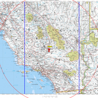
The U.S. Coast Guard has posted dates and times for GPS "service interruptions." The purpose is "to conduct GPS interference tests, exercises and training activities that involve jamming of GPS receivers." Affected locations are China Lake, CA, White Sands Missile Range, NM, Cape Canaveral, FL and the Nevada Test and Training Range.

Though the testing is brief (a few hours at a time), it is of multiple day duration. And don’t think it won’t affect you. Check out the map of the China Lake test area to the left. This is a massive area, defined by the red range ring (230 nautical mile radius) and blue lines (testing does not extend beyond longitude 115W and 120W). As shown, it includes all of L.A., Joshua Tree, Sequoia/Kings Canyon, Death Valley and Yosemite. I’m hoping the area really isn’t that large. Please, feel free to comment and tell me why it isn’t this extensive. There are some caveats in the test announcement; here is the full text:

read more

Garmin City Select vs. City Navigator

City_navigatorThis is a common question — which should I buy for my Garmin GPS, City Select (CS) or City Navigator (CN)? First of all, go to Garmin’s website and check to be sure that your unit is compatible and capable of auto-routing. Otherwise you’ll be paying for features that you can’t utilize.
Here’s the lowdown on the differences. CN was designed specifically for certain StreetPilot units; those units can take advantage of some sophisticated voice-prompted routing information in CN. Though CN can be ran on many handhelds, the map segments are much larger, with several exceeding the 24 MB limit of a number of units.  This is not just a problem in those areas; it makes it difficult to construct a trip along a linear route (can you say road trip?). To further complicate matters, Garmin is discontinuing CS, which has smaller map segments, replacing it with CN. This has caused quite a stir, and Garmin handheld owners aren’t happy
about it
. Apparently the company is listening though, and they seem
determined to shrink the map segments in future versions of CN.

CS is getting harder to find as a result of this phase-out. If you can
only find CS Version 6, don’t worry. As long as it is purchased (and
unlocked) after June 1, 2005, you are entitled to a free upgrade.
And there is some good news in all this; Garmin has cut upgrade pricing
for CN from $150 to $75 and on CS from $75 to $50. My advice? If you’ve
got a handheld, buy CS.


read more

OziExplorer Embraces GPX and KML

OziexplorerYesterday morning there was an announcement on the OziExplorer discussion board that a new version had been released which included support for .gpx and .kml files. The upgrade was a little buggy at first, or I would have reported it yesterday, but an updated version has been posted with a fix, and it works great.

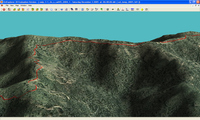
OziExplorer has long been one of my favorite mapping software programs. Even if you don’t use it everyday, there may be times when there is no substitute, unless you have access to a high-end GIS program. Ozi accepts shapefiles (.shp and .e00 formats) and allows you to import MrSID (.sid) imagery. The screenshot here shows a .gpx track, superimposed on a recent color aerial photo of my county (.sid format), re-generated in Ozi’s 3-D module.

OziExplorer allows you to download free USGS topo maps (DRGs) and aerial photos (DOQQs), providing a low cost way to get access to maps of much of the U.S. for free. There is a full chapter on Ozi in my book, GPS Mapping.  No program is perfect, but this one comes close. If they could only implement a better method for seamless map printing…

Geocaching Software and Paperless Caching

GeocachingIn this, the latest in our best of the (discussion) boards series, we take a look at geocaching utilities. Before we get started, here’s the place to go if you haven’t heard of geocaching.

While my book, GPS Mapping, covers a wide range of mapping software, I did not get around to reviewing geocaching utilities in it. I was pleased last week to see this post on geocaching software show up on the official geocaching discussion board. Sputnik 57, a geocacher from Texas, was kind enough to pull this list together, giving a little bit of space to each manufacturer’s blurb, and a link to their product:

  • Geocaching Swiss Army Knife (GSAK) is the all in one Geocaching and waypoint management tool. Major features include: Multiple databases, sending/receiving waypoints to GPSr, conversion to many mapping formats, HTML output, extensive searching, macro support, backup and restore, distance/direction from other waypoints (including caches, locations, post codes) and much more.
  • CacheMate™ is a database for tracking GPS cache hunts. You can store information about caches or benchmarks, decode hints, and transfer data between CacheMate and the MemoPad application. Registered users can import LOC and GPX formatted XML files, which are available from Geocaching.com.
  • Watcher is a program that lets you view GPX files obtained from Pocket Queries (a membership benefit for Geocaching.com members). Offline viewing. filtering, and sorting are all possible, as well as merging multiple GPX files and outputting custom GPX files. Watcher is a GPX utility available at no charge (although tips are always appreciated) to paying members of Geocaching.com. It is our way of saying “thank you” to all those who support the site from which we have found countless hours of enjoyment.
  • Plucker is an offline Web and e-book viewer for PalmOS® based handheld devices and PDAs. Plucker comes with Unix, Linux Windows and Mac OSX tools, scripts, and conduits that let you decide exactly what part of the World Wide Web you’d like to download onto your PDA (as long as they’re in standard HTML or text format). These web pages are then processed, compressed, and transferred to the PDA for viewing by the Plucker viewer.
  • GPX Spinner puts a spin on your GPX files. Features include: Output a set of HTML files suitable for sending to a handheld device using Plucker or iSilo; Change the waypoint name to include the cache name, ID, difficulty, terrain, or any combination; Change the waypoint description to include the cache name, who it was placed by, difficulty, terrain, or any combination;Change the symbol to represent the type of cache (e.g. a camera for Virtuals, a penny for Micros, or a picnic table for Event Caches). Even change the default ‘Geocache’ treasure chest for regular caches; Change the symbol (e.g. to an animal) if the cache contains any travel bugs; Change the symbol (e.g. to a tombstone) if there are several recent Not Found logs; Fully configurable!
  • EasyGPS is the fast and easy way to create, edit, and transfer waypoints and routes between your computer and your Garmin, Magellan, or Lowrance GPS. Using EasyGPS, you can manage all of your waypoints and routes, and display them in lists sorted by name, elevation, or distance. EasyGPS connects your GPS to the best mapping and information sites on the Internet, giving you one-click access to street and topo maps, aerial photos, weather forecasts, and nearby attractions. And because EasyGPS is part of the TopoGrafix family of outdoor products, you’ll be able to exchange GPS data with EasyGPS and ExpertGPS users all over the world!

I should add that the focus here is on software for paperless geocaching, relying instead upon a Palm or Pocket PC device. Also, as long as EasyGPS was mentioned, I want to let you know that there is a full chapter on it in GPS Mapping, since it is such a great (and free) waypoint management tool.

Creating Custom Maps for Lowrance GPS Receivers

In another of our continuing series of the best of the boards, this jewel comes to us from Groundspeak, the geocaching message board. In a Lowrance vs. Garmin response, I said…

…if you want to create your own maps, you can do this with the 60CS. With the H20, you can only add tracks. Lots of them, granted, but it is still a significant limitation, especially if you want to add contours.

To which Hoary, a geocacher from Massachusetts said…

There is a significant progress in regards of building your own maps for Lowrance iFinder. More details in Yahoo! MapCreate Format Group:

http://groups.yahoo.com/group/mapcreate_format/

Sure enough, information is posted there on a new tool, MP2LCM. I covered how to obtain data and create MP files in my book, GPS Mapping – Make Your Own Maps, but the ability to transfer those custom maps to current Lowrance units is a new development. Now I haven’t tried this yet, so if you have, chime in and let us hear your thoughts. Congratulations to the MapCreate Format group for all their efforts.