Sunday, March 18, 2012

Garmin GPSMap 60CS Review

60cs_1

UPDATE: This model has been discontinued. For more current recommendations, please refer to our handheld GPS buyers guide or our Garmin handheld GPS comparison chart.

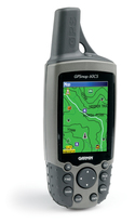
Regular readers of GPS Tracklog may recognize the Garmin GPSMap 60CS as one of my personal GPS receivers.  It’s my favorite workhorse in the stable at this point, and is highly visible in posts here and on the cover of my book, GPS Mapping: Make Your Own Maps.  The 60CS has it all — a bright color screen, turn-by-turn routing capabilities, on screen maps (separate purchase required), an electronic compass, and a barometric altimeter to accurately track elevation gain.

I’m planning to review quite a few of the current crop of GPS receivers over the next month or two, and it only seemed fitting to start with the 60CS. I highly reccomend it on the basis of two years of personal use. The menus are intuitive, and Garmin has an excellent reputation for customer service. The 60CS does double duty as a great ruggedized unit for the backcountry or a dashboard companion for highway navigation.

57 reviewers gave an average rating of 4 out of 5 stars at Amazon, which said the 60CS “is packed with navigational features, but Garmin knows that a great device has to go beyond a simple color display to be the cream of the crop. With that, Garmin has upped the ante on this lightweight, rugged, waterproof unit, offering a 256-color, highly reflective display that provides easy viewing in almost any lighting condition, including bright sunlight. This transreflective TFT, 2.6-inch diagonal screen provides excellent viewing while maximizing your battery life (up to twenty hours with typical use).”

read more

MotionBased: Online GPS mapping (review)

A couple of weeks ago I wrote that MotionBased, a website for online GPS mapping, had been acquired by Garmin. I’ve been playing with a Garmin ForeRunner 301 recently and used it to check out MotionBased, which keeps all your data online so that you can access it from anywhere. As a result, you can share trail info with others, though you do have the option of making your trails private. This is a great program for athletes, or anyone working on physical conditioning.

GPS based training

One of the strengths of MotionBased is its ability to integrate heart-rate data. It’s very cool to be able to overlay an elevation profile with your heart-rate graph. I had never thought about it, but my heart was pounding as fast going all out in the flats as when I was climbing a steep hill. Seeing such things is part of the wow factor for me; serious athletes will be more interested in seeing how long they stayed in various heart rate zones, and the multiple ways to view speed, distance and time data. This information is presented in both tables and graphs.

Multiple mapping modes

Now I like to stay in shape, but my perspective here is decidedly unathletic. I’m more interested in maps, and this is where MotionBased offers something other mapping software doesn’t.  Using their Map Player (which unfortunately will not yet work in Firefox), you can view a track superimposed on a street map, contour map, topo map, satellite image or elevation model!  You can even export the track to a .kml file for viewing in Google Earth. Here’s a link to MotionBased for a recent bike ride I did. Click the "Dashboard" button for a more extensive look.

Waypoints and routes are missing

No software has it all, and MotionBased has yet to add the ability to manage (or even show) waypoints and routes. But it is worth looking at for its other features. And it’s great to be able to view your trips anywhere you have an internet connection. If you own a Magellan or Lowrance GPS receiver however, beware—MotionBased is designed primarily to work with Garmin.

Cost

The free version, MotionBased Lite, gives access to mapping and analysis of your ten most recent activities. These limitations are removed with a subscription, which also gives you access to more extensive analysis features. Subscriptions to MotionBased Standard run $11.95/month, which is discounted 33% if you sign up for an annual plan.

This review just scratches the surface of a feature rich software program. I suggest trying it out yourself. Finally, stay tuned…in the near future I plan to post about the extensive data you can download from MotionBased for trip planning.


Garmin acquires MotionBased.com

Garmin announced this morning that it is acquiring MotionBased Technologies. MotionBased is an online GPS mapping service that offers a number of unique features. I’ve actually been using MotionBased for awhile now and plan to post a review in the near future.

I suppose this move should come as no surprise following this story last week. It appears that Garmin and MotionBased have had a cozy relationship for some time now, even sharing a booth at Outdoor Retailer this year.

UPDATE: Here is the MotionBased take on it, courtesy of their weblog, MBlog.

Making custom (not counterfeit) maps for your GPS

There was a story last week about counterfeit GPS maps causing drivers to get lost in Shanghai, which was widely reported in mapping blogs (like GeoCarta and The Map Room) and discussion groups.  But what do they mean by counterfeit maps? Jesse at Very Spatial started to address this, saying "I disagree with their use of the word ‘fake’, inaccurate is more realistic."  You can make custom maps for your GPS that may be sloppy or deceptive, or they may be more accurate than what you can buy commercially.

Let’s take a look at how this is done. What follows is a brief overview of a subject covered in great detail in my book, GPS Mapping – Make Your Own Maps, which includes step-by-step instructions.

Why would you want to do this? Well, you might be traveling to a foreign country for which there are no good GPS maps. Or you might just want better topo maps than what is available commercially. This is a common problem for outdoor recreation enthusiasts, as almost all GPS maps are based on 1:100K scale data, the one exception being Garmin’s US Topo 24K series (Amazon), which only covers national parks. Garmin’s US wide product (Amazon) shows contour lines 130 feet apart. I don’t know about you, but I like to know if I’m about to ride my mountain bike off a 100′ cliff! And while the Magellan (Amazon) and Lowrance products show contour lines much closer together, they actually interpolate the 1:100K data to do so, which is misleading to say the least.

On to how to make custom GPS maps…

read more