Navigating with a GPS during trips instead of an atlas has become more and more popular–but is it a risk for already-distracted drivers? As technology becomes more common, more and more people are concerned about distracted drivers becoming a danger to those around them. Phones are the usual culprit for such worries, but now the Department of Transportation has begun to point to GPS devices as well. read more
First Commercial Handheld GPS Celebrates 25 Years

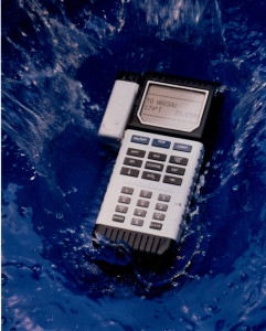
Weighing in at 1.5 lbs and taking 4 minutes to calculate latitude/longitude, this beast is currently on display at the Smithsonian National Air and Space Museum
Twenty-five years ago this month, Magellan released the first handheld GPS available to the public. The futuristically named Nav 1000 was primarily marketed to boaters in 1989. The handheld unit measured 8.75″ x 3.5″ x 2.25″ and weighed 1.5 pounds. The device was designed to be waterproof, non-corrosive, buoyant and constructed of a durable compound to withstand shock, vibration, humidity and temperature extremes. read more
MapSource Product Creator
 Ever had the itch to make your own maps? Wished that you had access to the same cartography tools used by Garmin? Well, your dreams may be coming true. A new MapSource Product Creator page on Garmin’s developer site offers you the opportunity to…
Create custom maps that can be easily loaded into Garmin devices with the MapSource Product Creator (MPC). The MPC can create everything from full country topographic maps to maps for specific industry, military or research applications.
GPS beats market research at own game
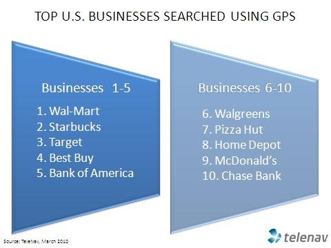
 TeleNav is releasing some data this morning that isn’t too startling in its own right, but it speaks to a revolution in market share analysis. Companies like Nielsen and Arbitron estimate media market share, but GPS-enabled phones can do them
 one two better, delivering location market share data, and not just estimates either. This strikes me as something of a game changer for marketing professionals, and the data may provide another badly-needed revenue stream for navigation providers. On to the specifics being released today…
TomTom to offer daily map updates?
 I’m never sure how much to trust Google Translate, but if they got this German article right, TomTom’s CEO Harold Goddijn (pictured) claims they will be offering map updates every day or two by the end of the year. It sounds like we are definitely moving towards connected devices with constantly updated maps. Here’s the translated quote:
More on Garmin BirdsEye aerial imagery
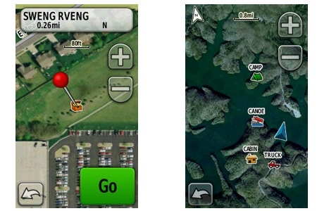
 The BirdsEye aerial / satellite imagery subscription program for the Garmin Colorado, Dakota and Oregon series is now official. EDIT: I’ve learned that Garmin decided not to support BirdsEye imagery on the Dakota 10, due to its lack of an expansion card slot. I have a few tidbits to add to my post from last week:
- The $29.99 subscriptions will be available starting this March
- Imagery will include “0.5 meter per pixel resolution in many areas of the United States”
- There is no mention of world-wide imagery in today’s news release, though it was mentioned on the Garmin BirdsEye imagery product page last week, which is unavailable right now
- Another BirdsEye web page has been announced, though it too is currently unavailable
- Image packets will be delivered in multiple resolution levels to avoid pixilation when zooming
- In response to a question, a Garmin PR contact told me “we have nothing to announce re: USGS maps at this time”; my take on that – it’s coming!
Garmin BirdsEye Satellite Imagery coming
 EDIT: I’ve learned that Garmin decided not to support BirdsEye imagery on the Dakota 10, due to its lack of an expansion card slot.
It looks like Garmin is getting ready to announce a BirdsEye satellite imagery subscription program for owners of the Colorado, Dakota and Oregon handheld series. Similar to DeLorme’s Map Library, the BirdsEye program will let you transfer an unlimited amount of satellite imagery and aerial photos to a compatible Garmin handheld for $29.99 per year. Imagery will be locked to one device per subscription; you’ll need Garmin’s free BaseCamp software (version 3.0.0+, yet to be released) and a myGarmin account. I hope to update this post soon with details on when the program will be up and running.
Lifetime map updates coming to TomTom models
UPDATE: Our TomTom XXL 540TM page has been posted.
Well, well. In what could be the biggest news coming out of CES in terms of auto GPS this year, TomTom has announced that they will offer Lifetime Map Updates, a feature that will be incorporated into a range of TomTom units released in 2010.
Hey Garmin – WTF?
 Garmin has apparently already made all their CES announcements. Lets see, we have a new golf GPS, a motorcycle GPS, a tool for high-tech grease monkeys and an app to make your nuvi curse like a sailor. The country’s biggest electronics show and this is all they have? WTF?
Well, actually, that’s a rhetorical question. I have some answers…
2010 GPS predictions
 Despite the relative success of my 2009 predictions, I hesitate to forecast anything this coming year. The GPS navigation market is in flux, undergoing a major shift from PNDs (personal navigation devices) to cell phones. That change, in itself, is fodder for multiple posts, but it also makes this the most difficult year yet to forecast. But hey, at the risk of playing the fool, here goes…

