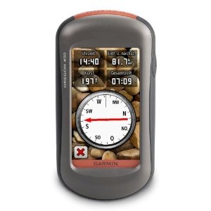
Hands on with the best Oregon yet
UPDATE: This model has been discontinued and replaced by the Oregon 600.
The Garmin Oregon 450 is one of the newest members of the touchscreen Oregon family, featuring the latest improvements such as better visibility, a tri-axial compass, custom dashboards, advanced track navigation features and the ability to load custom maps and BirdsEye aerial imagery. I’ll delve into those details shortly, but first I want to clarify the differences between the Oregon 450 and some closely…
Related units
- The Oregon 450t adds pre-loaded, 1:100,000 scale topo maps of the US to the 450’s feature set (see the next section for reasons not to spend the extra money!)
- The Oregon 550 adds a 3.2 MP geotagging camera
- Going the other direction, dropping down to the Oregon 300, you’ll go back to an earlier generation (less legible) screen and you’ll get a standard electronic compass
- To see how the Oregon 450 stands up against other Garmin models, check out my Garmin handheld GPS comparison chart.
Save your money
The 450t’s pre-loaded topo maps of the entire U.S. may appeal to those who travel a lot, but there are few other reasons to step up to that model. The reason? There are better quality 1:24,000 scale topo maps available for free for most states. GPS File Depot is a great source for such maps.
Custom maps and BirdsEye imagery
Then there is the recent introduction of Garmin custom maps. Basically, this allows you to put any map image on your Oregon. Found a park trail map online? Add it to your GPS! The image at left below shows a custom map — a USGS topo map (raster) image. You can read more about this feature by checking out my posts on Garmin custom maps.
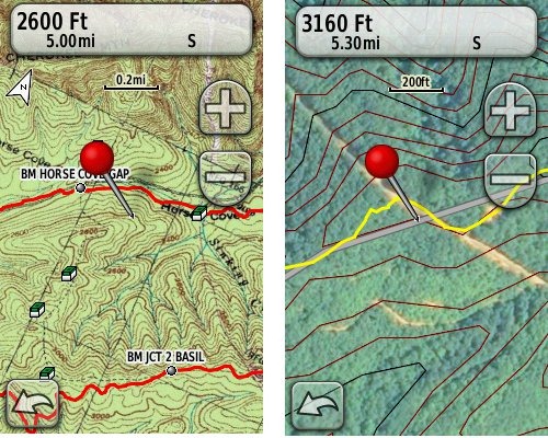 Garmin also recently announced their BirdsEye aerial imagery program, a $29.99 annual subscription that will allow you to add aerial imagery to the Oregon series. The image at right, above, shows a screenshot.
Now that we have that out of the way, lets look at some of the other new features in the Oregon line, which are all found on the 450…
Oregon 450 touchscreen display
All of the newer generation high-resolution GPS screens suffer a bit when it comes to visibility. The 550 series is slightly better than the x00 first generation, but the newer 450 series seems better yet. As a matter of fact, it’s the first Oregon I’m going to recommend for fixed mount, non-powered use, such as bike handlebars. In the past, I’ve recommended Oregons primarily for handheld use, where you will intuitively tilt it for the best view.
Let me back up a bit and share what I saw when testing the Oregon 450. The first time out on my bike, I was surprised by the visibility, but when I took the 450 off my handlebars, and held it side by side with my 400t, I couldn’t tell much difference looking at them straight on. Once I tried different angles though, it became clear to me that the 450 was viewable over a wider range than the older model. I don’t recall seeing this when I tested the 550t, so I asked Garmin if there had been changes between the 450 and 550 series in regards to screen technology. Here’s the response I got:
While the most notable enhancement in our Oregon screens was from the x00 to the x50 lineup, customers may notice other improvements that are a result of various hardware and software improvements.
The difference is seen in sunny, bright conditions only. I could not detect much difference in shade. And regardless, in at least some conditions, the 450 still isn’t as bright as older units that don’t have such high resolution screens (e.g., the 60/76C and eTrex C series). But the huge number of improvements the Oregon series is accumulating leaves me with little reservation in recommending them over previous model lines. With the recent improvements in screen technology, visibility just isn’t a deal killer, even for bikers. Even so, I still recommend that users create sun and shade profiles to improve visibility (discussed a little later in this review).
Portions of the following are taken from my Oregon 550t review.
Oregon 450 tri-axial compass
Having a tri-axial compass means you don’t have to hold the unit level while navigating. The downside is that the calibration process is more complicated than that for a two-axis electronic compass. It’s the same procedure that is used on the Dakota 20 — here’s a brief video I shot of it. The compass should be recalibrated every time you change the batteries in the unit. Like most GPS receivers with an electronic compass, the 450 also includes a barometric altimeter.
Garmin Oregon 450 Interface
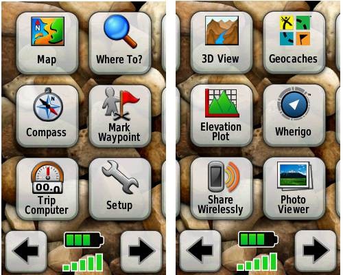
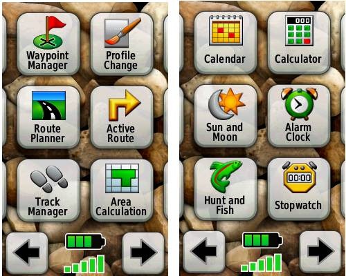
Handheld GPS receivers typically offer lots of options, and can be overwhelming for a first-time user. Even so, the Oregon is about as intuitive as they get, and I love the touch screen menus. The main menu is spread across five screens (as shown below); these can be customized, so if you don’t need “Man Overboard”, you don’t have to display it.
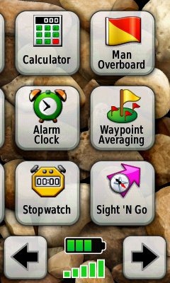
Customizing the Garmin Oregon 450
Take the time to do some additional customization and it gets even better. Here are some tips:
Use profiles – There is a “Change profiles” item on the main menu, and you can create a new one via Setup > Profiles. Tap the new profile to give it a name. Now start changing various preferences. Want track up when geocaching and north up when biking? No problem. The possibilities are nearly endless.
Rearrange the main menu – Set this different for each profile. I make extensive use of the Track Manager, so that gets moved to the first main menu screen for my hiking and biking profiles.
Create sun and shade profiles – A great use of this tool is to create separate sun and shade profiles (perhaps even one for each activity). Create a Sun profile and then go to Setup > Maps > Advanced Map Setup. Set Shaded Relief to Do Not Show to enhance visibility in bright light. If you’re in an area with lots of national parks and forest, you can also improve visibility by getting rid of the green background. Go to Setup > Map > Advanced Map Setup > Zoom Levels > Land Cover and set it to Off. Credit GPS Fix with originating these tips for sun / shade profiles.
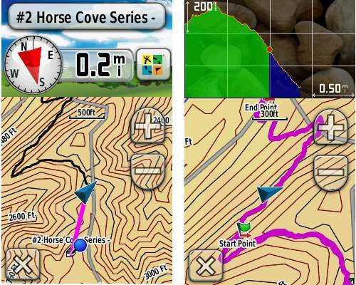
Dashboards – The map screen can be set up to show 0, 2 or 4 data fields, or to display a dashboard. Choices for the latter are recreational, automotive, stopwatch, compass, large data field, geocaching (nearest or active) or elevation plot. I’ve included screenshots showing the last two below.
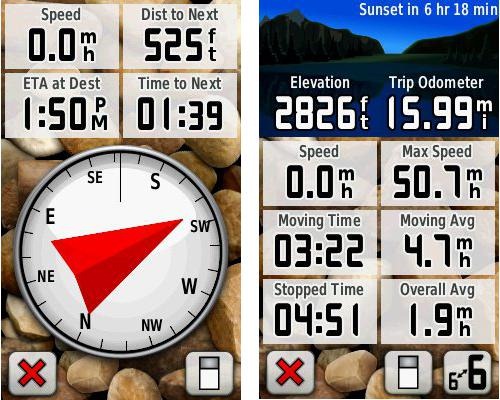
Shown below are the compass and trip computer screens. The data fields can, of course, be customized, as can the background. The trip computer screen can be also switched to show fewer (but larger) data fields. The top section of each can be modified display one of the previously mentioned dashboards.
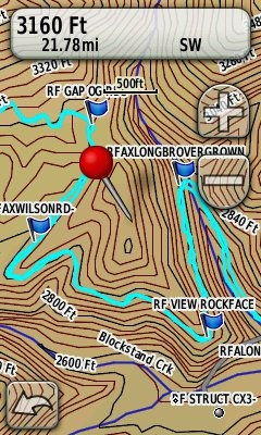
Finally, here’s a random interface tip… When you select a location on the map, a push pin appears. You can now slide the map around underneath the pin, and zoom in as needed, to fine tune the selected location..
Route, Track and Waypoint management
 The Oregon series has excellent route, track and waypoint management tools, including:
- Waypoints – The ability to project a waypoint, and to reposition one at your current location.
- Tracks – You can choose to hide or show tracks on the map and give them a custom color (17 colors are available). The image at the right shows a track in light blue (a record of a previous trip).
- Routes – You can view a map of the entire route, edit the route, reverse it and view an elevation plot.
Track Navigation
The Oregon 450 features some recent improvements in track navigation. Select a track to navigate and a route will be created. Waypoints are created for the high and low elevation points and any user waypoints along the track are added to the route. I’m a heavy user of track navigation. If I head out for a trail I’ve never traveled before, I do a search online for tracks (favorite search terms are .gpx, gps, trail name, and park name) and load the track to the device. One advantage of this new track navigation feature is that, unlike typical backcountry route navigation, you’ll get an estimate of actual trail distance rather than “as the crow flies” mileage.
Geocaching with the Oregon 450
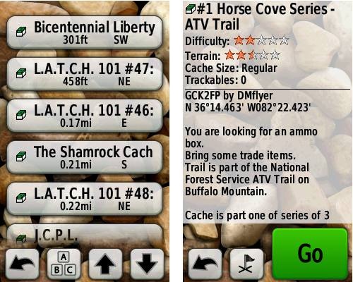
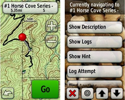
The Oregon 450 is a nice GPS for geocaching, as it is set up for full paperless support, meaning you can see the description, logs, and the hint, and you can log your attempt (find, DNF, etc.) for later transfer back to geocaching.com. Speaking of which, full access to these features requires a premium membership at geocaching.com. Shown below, clockwise from top left: Closest geocaches, geocache description, menu for a specific cache, and custom map using a USGS topo.
Wireless data transfer
The Oregon 450 is capable of wireless data transfer with other compatible Garmin units. You can transfer waypoints, tracks, routes and geocache summaries (paperless caching details cannot be transferred).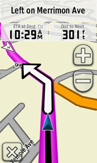
Garmin Oregon 450 in your car
The Oregon 450 makes an excellent dual-use unit, though you’ll probably want City Navigator and a car kit if you want to use it as a turn-by-turn navigator in your car. If I wanted a single unit for trail and road, an Oregon plus City Navigator (screenshot at right) would be my top choice.
Garmin Oregon 450 performance
The Oregon 450 performed very well for me in testing against multiple units including the Garmin GPSMAP 60CSx and the Magellan eXplorist GC. I noticed no significant differences in accuracy at ground zero when geocaching.
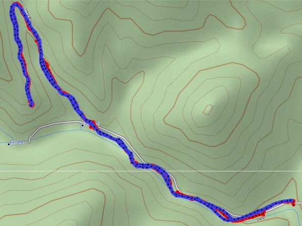
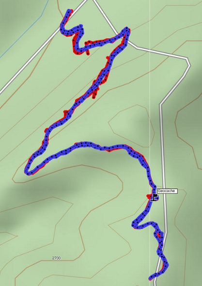
Multiple tracklogs were collected, comparing the Oregon 450 and the Garmin 60CSx. Tracking was set to collect points every five seconds while mountain biking. Steep terrain ridden in both directions, combined with frequent stops to record notes, resulted in good testing environments. In the images below, the Oregon 450 tracklog is in blue, the 60CSx is in red. I’ve compiled these four tracks in a single .gdb file, which you can download and open in MapSource or BaseCamp for closer examination.
In one test, shown below, the 60CSX wandered a bit more than the Oregon in a few spots, while the Oregon track separated more at one point on the uphill and downhill runs. This test was a draw.
In the test below, the Oregon significantly outperformed the 60CSx. I’ve labeled a geocache at one point, because I moved around a fair bit there. Still there were two other points where the 60CSx wandered significantly. Each unit had a single instance of track separation on the uphill and downhill segments.
Battery life is rated by Garmin at 16 hours. In my testing it ranged from 10 hours, 27 minutes (backlight always on) to 16 hours, 51 minutes (backlight timeout set for two minutes, battery saver mode enabled). Battery life tests were conducted with the unit stationary, using Eneloop low discharge rechargeable batteries.
One other performance note — I’ve always been very impressed with how accurately my 60CSx reports overall elevation gain, and disappointed with the inaccurate numbers generated by my Oregon 400t. I was pleasantly surprised to see that the Oregon 450 is extremely close to my 60CSx in terms of reported elevation gain. I hope to do some more testing before I send the review unit back to Garmin, and will post a full report here.
UPDATE: Well, I set out on the trail to test this out and to my surprise, the 400t, 450 and 60CSx were all within 2% of each other. Perhaps Garmin fixed this on the Oregon x00 series in their most recent firmware update. Go figure!
Garmin Oregon 450 pros
- Tri-axial compass
- Barometric altimeter
- Great touch screen interface
- Ability to customize display and menus using profiles
- Excellent track management and routing tools
- Paperless geocaching support
- Availability of free maps
- Accepts Garmin custom raster maps
- Accepts Garmin Birds Eye imagery
- Improved visibility over previous Oregon series
Garmin Oregon 450 cons
- Somewhat poorer sunlight visibility than eTrex and GPSMAP color units
Recommendation and conclusion
Highly recommended. The Oregon 450 is a great workhorse, at a reasonable price. The interface is very user friendly and it has a lengthy feature set. It is an excellent choice for nearly any outdoor activity, including geocaching and hiking. This is the first Oregon I’m recommending for bikes too, due to the improved screen visibility, which makes it more appropriate for fixed-mount use.
More Garmin Oregon 450 reviews
- Consumer-authored Garmin Oregon 450 review
have been posted at Amazon
- More consumer reviews of the Oregon 450
have been posted at at REI.com
- A first impressions user review of the Oregon 450
- It’s Not About the Numbers reviews the Garmin 450 from a geocacher (and Blackberry user’s) perspective
I’ll be posting more hands on GPS reviews as they appear, but in the meantime, here are some…
Other Garmin Oregon 450 resources
- The Garmin Oregon 450 owners manual, in the language of your choice
- A Garmin Oregon message forum
- Use this chart to compare the Oregon 450 to other Garmin handheld GPS models
- There are links to more handheld GPS reviews in our buyers guide
- The Garmin Oregon wiki has an Oregon FAQ
- Trying to decide between the Oregon 450 and the Garmin 62 series? Maybe this will help
- Garmin Oregon training videos
- The official Garmin Oregon 450 web page
Compare prices on the Garmin Oregon 450 at these merchants:
- Check the current Garmin Oregon 450
price at Amazon
- Find the Garmin Oregon 450t at GPS City, one of our favorite low cost vendors
- Buy the Garmin Oregon 450
direct from Garmin
- Get a great deal on the Garmin Oregon 450 Handheld GPS
at J&R Computer
- Check out the deal on the Garmin Oregon 450 GPS
at REI.com, where satisfaction is guaranteed and members get 10% back on eligible purchases
- Get the Garmin Oregon 450
for an amazing price on eBay


Rich,
When you did the battery test for the 450, at what setting was the backlight for both the always on test and the backlight timeout set for two minutes, battery saver mode enabled test?
thanks,
nick
Ooh, not sure. Probably 100%, but don’t know for certain. Guess I should note that on future tests, huh?
Rich just received the 450 yesterday…wow NICE unit….can’t wait to get out with it…took only a week to get it from REI….it was backed ordered also….I’m really glad I went ahead and bought one…the $249.00 deal was a great one…Oh. what kind of batteries do you use….also where should go to get a case for it..
Pete
Hello Rich,
Looks like the 450 has really taken off! Backordered? Wow. This is just a note from the field to update you on just one aspect of my experience with it: its ruggedness. I can’t compare it with how rugged other GPS units are, since I only own this one, and this is my first GPS.
OK, answering the question, “How rugged is the Oregon 450?”: VERY! My chief use is on my road bike, where I travel to back county roads I’ve never seen before. I get caught out in the rain every once in a while, and the downpours just clean it off. Some of those roads are chip-sealed, where the gravel is spread over fresh tar, and they can get very bumpy. So bone-rattling, in fact, that at least three times, my Oregon 450 shook loose from its cradle (the one from Garmin) and fell while I was moving 16-20 mph. As the old Timex commercial used to say, “It takes a licking, but keeps on ticking.” The back cover came off and the batteries spilled out one time, the shock was so hard. I’ve since been more careful about how firmly I snap the Oregon 450 into its mount, and improved the way I strapped the mount to my road bike (since then, no more unexpected nose-dives), but…after hundreds of miles after its last tumble, my 450 still works like new. The rubberized housing has a few dings and scratches, but that’s the extent of the damage. I have the Zagg invisibleSHIELD you recommended, but I don’t think the screen has ever taken a direct hit. I can’t say how the screen would hold up if it fell and hit a rock, right on the screen. But I can say that, while I don’t recommend testing an Oregon 450 by throwing it against the tarmac, mine still works perfectly after the unintential abuse I’ve described.
Wow! Was it just not snapped into the mount all the way? A good safety measure is to loop an attached lanyard around the handlebars, but that could present other hazards if it does pop loose! Your story reminds me of this, posted yesterday…
http://garmin.blogs.com/my_weblog/2010/09/garmin-dakota-gets-high-praise-after-high-speed-tumble.html
@Pete – I use Eneloops and love them. This is old (I keep meaning to do a new post on it because they are awesome)…
http://gpstracklog.com/2007/11/eneloop-recharg.html
I don’t use a case, just a screen protector, which I highly recommend. I use Invisible Shield by Zagg.
Hi Rich,
Judging from your continued upbeat tone in your replies, you don’t look like you’re too worn out by all this activity on the Oregon 450…so…I have a tech question for you. The answer probably applies to just about every GPS made, however. The question is, how does a GPS (or, the Oregon 450 in particular, to make it relevant to this thread) calculate an overall route distance when you’ve actually finished travelling it? Does it sum the straight line distances between the individual electronic “breadcrumbs” it posts along the routes? If so, that would explain why my bike’s computer always seems to come up with a slightly longer distance, even though I’m basing the odometer’s internal settings on my bike’s actual wheel rollout. The bike’s odometer is calculating distance based on the actual cumulative distance rolled by the wheel, which includes all the little wobbles and deviations from a straight line that I travel. Can you enlighten me about how the GPS’s odometer works or refer me to some basic source of beginner’s info?
Yes, I believe it will basically measure the distance from one tracklog point to the next. This is one place where there are still some firmware bugs. All of the new Garmin units with STM Cartesio chipsets tend to under-estimate low speed (walking/resting) mileage in the odometer field. However, the actual current track distance is usually spot on.
Since this is your first GPS, this series might help…
http://gpstracklog.com/handheld-sport-gps/handheld-gps-101
Rich;
Based on your comments and those from other owners, I bought a 450. I’m learning how to use the basics, but one thing I can’t figure out…. A couple of days after I bought it, I was tracking some waypoints, and I got visual pop-up notices whenever I came close to a the next waypoint. But now, a couple of weeks later, I no longer get those alerts. I’ve not uploaded any custom maps nor planned any routes with external software. The only thing I’ve done is to update the software version to 3.8. Can you tell me how to re-enable the waypoint alerts?
Hmm, did you change Profiles?
No, I haven’t played with profiles at all. I went for a walk again last night and confirmed that I get no proximity alerts on Tracback.
Are proximity alerts something that should work on the 450? I definitely was getting them for a couple of days immediately after I bought the unit. At that time, I would get a pop-up message telling me that I was approaching a waypoint. The message had an “OK” button for me to push to dismiss the message. But it went away automatically after about 3 or 4 seconds. I’d really like to get those messages back, and I’d really like for them to remain displayed until I tap the “OK” button.
Thanks for any advice you can give.
geo
What if you just navigate to a waypoint (as opposed to being in trackback mode)? Will they come up then? I don’t think they’ll show up on trackbacks.
Sure enough…. If I navigate to a single waypoint, I get the alert. It asks me to push the “OK” button, but after about ten seconds, it goes away by itself.
Gosh, it really would be nice if waypoint alerts would occur anytime I’m navigating. It would make sense that on Tracback or following a route (especially one built from waypoints) that the alerts should occur. It seems like a reasonable enhancement request for Garmin.
Thanks for your suggestion.
geo
They may have their reasons for this implementation. You may already be doing this, but when navigating a track, I like to use Distance to Next and Waypoint at Next as data fields.
I just bought the 450 for CDA$350 after selling my 6 year old Garmin Legend for $60.
I also downloaded a 20K:1 topo map of my area-Northern Ontario for $50.
So far I love the 450 and the topo maps. I look forward to learning how to use all the features and functions.
For the money the entertainment value of this device is fantastic.
I did some tests on the accuracy of the 450’s trip odometer. My comments are here:
http://garminoregon.wikispaces.com/message/view/home/27480085
geo
Thanks for sharing! I agree that TopoFusion elevation gain is always off. To get the most accurate elevation gain reports, I reset the trip computer at the trailhead and then note the total ascent on the altimeter page at the end of the ride/hike.
Hello,
What I mainly look for in GPS is reliability under any conditions – tell me where I am and get me where I’m going, even in bad weather. I currently have an Etrex Vista Cx which I use for hunting and my main gripe is the poor sensitivity it has in moderately thick woods (i.e. leaves on the friggin trees) as well as in the deep ravines of Southeastern Ohio. Can you please comment on the Oregon’s performance under these conditions?
Andy
Andy-I bought the 450 a few weeks ago and have used it extensively in the wilds of Northern Ontario both grouse hunting and backpacking. The signal is always strong-even in my truck and in thick tree cover.
I had a Garmin Legend and had the same issues you made mention of.
The 450 is outstanding with my 20K;1 topo maps of Northern Ontario
I agree. I think it’s as good as any consumer GPS out there. I especially like that it doesn’t wander / spider when standing still like the 60CSx.
I’ve been enjoying my 450 for a couple of weeks..however I do have a question…when the batteries are going dead and I want to change them how do I save my trip I’m presently traveling…????? I guess… if I remove the batteries from the back the the 450 will turn itself off….???….or when it turns back on with the new battries will it save the previous trip logged.???
And another question…if running off a 12v power source off of my ATV…when I turn the ATV off the GPS will turn off…why won’t the batteries take over when the 12v is turned off….Does this mean I have to wire the 12v source direct to the battery to keep it on..???
I haven’t yet used the 450 on a backpacking trip, so I can’t speak about the tree cover. However, a couple of weeks ago I took an overnight car trip. I turned on the 450 and left it in the trunk the entire time. I thought the car’s body metal would block the satellite signals, but I was pleasantly surprised to find that the 450 tracked the entire trip correctly. The 450’s trip odometer was spot on, compared with the car’s odometer. And when I looked at the track in Google Earth, there were no gaps in the log points.
geo
The trip / track will not be cleared when you change batteries. No need to do anything. If you change batteries immediately, it will be recognized as a single track.
Not sure about the other question. You might try putting it in Spanner mode (Setup > System > Interface) and see if that changes the behavior. You’re not in Automotive mode are you? I could see it being set this way for car use.
Have you experimented with the Sight N Go feature? I have experimented quite a bit, and mine isn’t very accurate on the direction that you lock in.
Not that much. Is that your thread on Groundspeak? I assume you’ve calibrated the compass. You could use a separate compass for getting the bearing and then use Project Waypoint.
That is my thread on Groundspeak. The GPS works great for every other thing I have used it for. The antenna in heavy cover is impressive. This Sight N go function seems to be very inconsistant. I have tried re-calibrating the compass, and went through all my settings trying to figure out what may be causing this. For example, the last time I tried to use it, I was out in an open prarie and sighted an object at 340 yards. I locked the direction 3 times to check how accurate I was holding the GPS. It was 188, 189, 188 degrees. The third time I entered the yardage of 340 yards. I walked straight to the object, and when I arrived, the compass arrow was pointing 90 degrees to the right with a distant to destination of 380 feet! As much as I like this GPS, it’s frustrating fighting this function, which could be very valuable to me. I have also been in touch with Garmin several times, which hasn’t been productive at all.
Doug
I’m curious as to how it compares with previous units you’ve used in the past for the same purpose.
Don’t laugh now……my last unit was a Garmin GPS III…..it didn’t have that feature.
Ah, that’s quite a change. Looking forward to hearing if you can sort through this and make it work any better.
Well, I just talked with my hunting buddy who bought the same GPS a couple weeks ago, and he is doing the same thing. My thoughts is that the compass flucuates internally to much to get an accurate and consistant lock on the direction. I have a few ideas i want to try yet.
I found your website just in time, Really informative… I have a question about the compass screen on the oregon 450, Can you set it up to show only 2 windows?
My eyesight is getting worse and worse, I’m a surveyor for blm and i use garmin to find corners, I need the bearing and distance only, My 76 map unit gives the option of 4 or 2, I can see the 2 without glasses, I hope i can set the 450 up the same way, Also, How do i set it up to give a bearing like n45e, Or at least an azimuth, The NW,SW etc. Doesn’t help much… THANKS …KEVIN
I’m traveling, and don’t have an Oregon with me to test. You can definitely show just two data fields, but they won’t increase in size over four. I think you can show one, which might increase it. The data screen has an option for big fields, so that would help. Will check when I get back to my units in a few days.
You can give a bearing too. I have notes on how to do it on the 62 series. Should be pretty much the same on the Oregon…
You have to go into setup and change Heading to display numeric degrees. Then you can set a data field to show the bearing. Until you do this it will just show cardinal direction.
Okay, just checked. You can set it to 2 or 4 fields, but it doesn’t change their size. Does it on the 76? There is a recreational dashboard option with two data fields that may give you better contrast. And there is a large data field option, but you only get one field.
Another option is to use the Trip Computer screen, set it for large data fields (you’ll get three) and select pointer, bearing and distance for the 3 fields. If you can live with the pointer field instead of the full compass screen, this may be the best option.
Hope this helps!
I just purchased this unit on sale at Bass Pro Shop for $269.00 !! What an awesome deal for such a high end handheld. I have geocached with it for a couple days and an very impressed.
Cool! You’re lucky — that deal has come and gone. It’s now $399!
Hi..had a few quick q’s…
I’ve found the 450t for $299 and the 450 for $269…I don’t understand how the 450t 100k maps are stored vs. the plain 450 which has no maps. Are the 100k maps on an SD Card or are they built in somehow? If you hard reset the 450t do you lose the maps? Are they on disk when you purchase unit and you put on SDCard…etc.
Can I get the 450t and still purchase and use the 24k maps at the same time? It appears they are on a DVD…so I suspect you put them on an SDCard to use???
The 450t 1:100k maps are stored in built-in memory. A hard reset won’t erase the maps, but it is a good idea to back up the entire device to your computer, especially if you’re going to be messing around with the files on it.
Yes, you can add 24K maps to it. They can be loaded to internal memory or a micro-SD card.
Unless you travel across the country extensively, I recommend the 450 rather than the 450t. There are a lot of good quality free 24k maps available at http://gpsfiledepot.com.
Hope this helps!
I just got the Garmin 450, based on your recommendation, and am trying to load some useful maps. The .gmapi ones seem to work fine but I can’t seem to get a .gpx topo trail map to load on the unit itself, even though it shows up on the Custom Maps folder within Garmin. Isn’t this supposed to work with the 450/am I doing something wrong? If I double-click it, it opens my email. Please help!
.gpx files go in the Garmin/GPX folder. They should show up under the Track Manager. You’re welcome to ask any and all questions here, but this is an awesome site to check out too:
http://garminoregon.wikispaces.com/
re TOPO U.S. 24K: if I add this software to a model oregon 400 will it do turn by turn directions (say on a bike on the road) or in a vehicle or would I need to add city navigator as well?
Yes. Nice, huh?
Great website! Thanks!
I have been doing surveys where I need to mark locations of elements in the field. All I have had to use is, ahem, my Nuvi 255W. It works well enough except for battery life which is too short. I’ve had it shut down on me more than a few times.
I also plan to use it to map trail running and mountain biking routes to pass on to others.
I’ve been comparing the Oregon 450 and the 62S. Both are nice units. The 450 appears to have far less storage space for uploaded maps compared to the 62S. Different maps will, of course, have different size requirement but can anyone comment on typical map storage requirements?
Both have micro-SD slots for additional storage. I just checked and a 1:24,000 scale map of North Carolina is 203 MB.
So the limited in-device storage is really a non-issue since it can take external cards…
I made up my mind and purchased the Oregon 450 plus a microSD card. Should get it in a few days.
Thanks!
DavidB
Cool! Let us know what you think once you’ve had a chance to use it some.
Hi Garmin Man
Just got the Garmin 450 & busy studying manual. Few things I cannot access & want to know if these are add-ons.
1. Have no access to POI,s in specific places.
2. Have no 3D View
3. Have no Topo map views.
4. Cannot access the Automotive feature for car travel.
Are all these add-ons I need to buy? Are there on-line sites that I can access topo maps or 3D layouts?
I do a lot of hiking in Colorado. If I know of trails how can I add trail profiles to my Garmin 45o incl. all the topo, elevation & 3D features?
I’ll probably have more questions but I’d appreciate your help on these questions.
Thanks
Mike
Mike — Congratulations, the 450 is a great unit.
The Oregon 450 has no preloaded maps other than a basemap, so there’s no topo map or POIs.
The best source of free maps is http://gpsfiledepot.com. Highly reccomended.
3D mode is only available if you have a map with DEM data, like one of Garmin’s topo products. Useless eye candy anyway. Likewise, you can’t do highway routing without adding highway maps. If you really want that and 3D, the best option is Garmin’s 24K scale series for your area, which includes highway maps.
You can add trails not found on maps by downloading tracks. See the end of this post for more details…
http://gpstracklog.com/2010/03/handheld-gps-101-tracks.html
Another helpful resource is found at http://garminoregon.wikispaces.com/
Received my Oregon 450 the other day and have had some time to review the manual, become familiar with the interface/setup, and one field trip.
Initial impression is favorable!
The touch screen works for me since the only other GPS device I own is a Nuvi 255w and I am comfortable with the screen. Besides, so many electronic devices these days — including many smart phones — are touch screen so the technology is becoming fairly mature.
One feature that I would like (and perhaps I just haven’t figured it out, yet) is how to change the auto increment for waypoints. That is, if I set a point 001 the next point is 002, then 003, etc. Since I already have a substantial collection of numbered waypoints, I would like to have the device auto increment starting with a higher number. Sure, I can edit the tag but that gets old.
The accuracy is okay but while doing a trail and reversing direction on the way back the tracks were clearly separated. I haven’t tried WAAS yet — that’s for another day.
I did learn that a trail run that I estimated at ~7 miles is actually 8.2 miles. I’m running farther than I thought!
I sucessfully uploaded some Topo maps that I already had from gpsinfodepot. Also tried to upload the Nuvi 255w City Navigator Map but that was a no-go because I was unable to unlock it without purchasing another license from Garmin. Not that important anyway since I’ll use the Nuvi for driving.
All for now…more later as I get additional chances to use it.
DavidB
Sounds like you’re having fun with it! I don’t think you can change how waypoint numbers are auto-generated, but as you noted, you can edit the names.
I wouldn’t necessarily trust the odometer for accurate trail mileage. Track mileage tends to be much more accurate. Try going to Track Manger > Current Track > View Map to check the distance and see how it compares. This is a bug (less accurate odometer mileage) that may have been fixed; I’m not sure.
Out and back tracks will often show some separation at points, but it usually shouldn’t be over 50′.
Regarding Waypoint naming: As I suspected. I’ll keep doing what I’ve already been doing; i.e., manually numbering the points and keeping a written log what each point represents as part of my survey.
Regarding Distance: I didn’t use the odometer feature. Rather, I downloaded the track and used BaseCamp to get the distance.
Next — need to purchase a USB cable that will also recharge the NiMH batteries.
Thanks for the response!
DavidB
Ah, yes, the tracklog should be very accurate. Also, I don’t think you can charge batteries while in the device, if that’s what you mean.
Well, that didn’t last long. Device is only partially functional. Will not power on using batteries (tried different sets, all good). No joy.
It will power up using the USB cable.
Suggestions? Will probably contact Garmin when I get a chance.
DavidB
Just got a Garmin 450. Will use for geocaching. Downloaded waypoints easily from geocaching.com or GSAK. One question? How do I delete a geocache? I can delete waypoints, but I see no way to delete Geocaches. Otherwise it seems wonderful.
Thanks
Kevin Passe
You have to connect it to your computer and delete the .gpx file…
http://garminoregon.wikispaces.com/Geocaching#FAQ-GC9.%29%20Can%20I%20delete%20Geocaches%20from%20the%20Oregon%20user%20interface?
Rich… got a question .Does the cold weather effect the display…I’m planning on using my 450 on my ATV on the lakes this winter when I go ice fishing…weather temps around 10 to 30 degress…not taking into account the wind chill factor. I have a handlebar RAM ball mount…or should I keep the unit inside my jacket??
I would keep the GPS in my pocket when not in use.
I live in the cold of Northern Ontario. Keeping any devices with batteries, including vehicles, SLR’s, GPS’s or LED headlamps as warm as possible is always a good idea. The batteries drain much faster when exposed to cold.
I will be using a 12 volt hook up off the ATV 12 volt plug..so the batteries are not an issue…any issues with the LCD screen….or the unit itself..maybe I should write to Garmin…?? or check the manual..
Garmin doesn’t specify a temperature range, but I think you’re okay down to about zero. I agree that battery life will be more of an issue. Lithium batteries will perform better in such temperatures.
I put a screen protector on my 450 as well as my new Sony a33 DSLR, my Blackberry and iPod. I had a habit of scratching the screens on my devices:(
@DavidB — That is strange. I haven’t heard of many problems with the Oregon series. Where did you buy it? It might be faster to return it to them as defective.
After a number of attempts inserting batteries then removing them, then plugging into USB, Reset, etc., all is working well again. Not certain what happened but Operator Error is a possibility that should be considered 😉
DavidB
Very strange. Glad its working though.
I copied and pasted this from the website manual…it does have the temp range listed Rich..
Specifications
Physical
Size: W × H × D: 2.3 × 4.5 ×
1.4 in. (58 × 114 × 36
mm)
Weight: 5.1 oz. (146 g) without
batteries
191.4 g with batteries
Display: 3 in. diagonal (76 mm)
backlit 65K color TFT
display (240 × 400 pixels)
Case: Rugged plastic,
waterproof to IPX7
Temperature Range: From -4°F
to 158°F (from -20°C to
70°C)*
*The temperature rating of the Oregon
may exceed the usable range of some
batteries. Some batteries can rupture at
high temperatures.
Source: Two AA batteries
(alkaline, NiMH,
lithium, or precharged
NiMH) alkaline not
recommended for
Oregon 550 and 550t
Battery Life: Up to 16 hours
accuracy
GPS: < 33 ft. (10 m) 95% typical*
*Subject to accuracy degradation to 100
m 2DRMS under the U.S. DoD imposed
Selective Availability (SA) Program
when activated.
DGPS: from 10 to 16 ft. (from
3 to 5 m) 95% typical
(WAAS accuracy in
North America)
Velocity: 0.328 ft./sec. (0.1
m/sec) steady state
My bad. Now I know where to find it!
Is there a difference in the Garmin Inland Lake Vision Northeast map (download only version) compaired to the Garmin Northeast Inland Lakes Micro SD map?? Is the download version a newer map???..if so.. are their any newer features?? I originally wanted to buy the microSD Northeastern edition but it’s looks like it only comes in a download map on the Garmin website. I can still find the Northeastern Inland microSD versions on line. I have never downloaded a map off of the Garmin site…I’m not sure which one to buy. $99 for the download one OR $87 for the Micro-SD one
Its kind of out of my realm of expertise, but here’s what I’ve surmised.
The Vision features don’t work with the Oregon series…
https://buy.garmin.com/support/searchSupport/case.faces?caseId={79bd0670-838e-11df-4d49-000000000000}
So you may just want the full coverage non-Vision version, which is available on SD cards…
http://www.garmin.com/garmin/cms/site/us/lang/en/inlandlakes
One advantage to buying a pre-loaded microSD card — assuming they are like other Garmin mapping products, they are not locked to a single unit. Should you upgrade GPS receivers in a couple of years, you could use the card in another unit. I don’t know how often these are updated BTW.
Rich thanks for info..I have one more question.. I can still get the Northeast micro version from LL Bean for $87…OR the full U.S. version for $139 from Garmin…any difference between to two…???…besides the price..I only would need the Northeastern version..
Rich thanks for info..I have one more question.. I can still get the Northeast micro version from LL Bean for $87…OR the full U.S. version for $139 from Garmin…any difference between to two…???…besides the price..I only would need the Northeastern version..
the LL bean site is listed here..http://www.llbean.com/llb/shop/70278?pi=1121169&subrnd=0&qs=3006448_pmd_amazon
will this one work in my Oregon???
It should, but…
It isn’t clear if its a Vision card or not. If not, it could be an older, discontinued product. What’s their return policy on a product like this?
Rich…Well I just got off live chat with LL Bean….they told me it will fit the Oregon and that I could return it…if you zoom in on the tag on the packing (lower right corner) you can see Feb 2008…so it must be an older version…looks like I will get it…these are hard to find…and the price is a good one..
Some reactions here deal with waypoint directions.
My problem with the Oregon 450 (and the 62) is that it does NOT give directions while navigating tracks. It only navigates routes. Converting cycling tracks into routes is a cumbersome thing to do, even using GPSBabel.
When navigating tracks: distance to next = distance to destination. Always!
This is a main flaw of Garmin. It makes the unit pretty useless. In the manual: no mentioning of theat fact.
Another flaw: every wp, track or route you downloads to it, is written in a separate memory. If you delete them on the unit, …. they are still there! Waypoint numbering now starts at 011. No way to reset it to start with 001. So somewhere hidden is a separate meory which you cannot delete. Apparently in the background the unit is fulling up its memory.
I’m not satisfied with the Oregon, especially because of this lack of turn by turn dirfections.
Meanwhile I congratulate eveyone who enjoys it.
Frank
(The Netherlands)
If you are road biking, you need a routable highway map (e.g., City Navigator) for turn by turn directions. If you’re off road (or even on road) and have waypoints at junctions, you’ll get distance to next…
http://gpstracklog.com/2010/07/navigating-tracks-on-the-new-garmin-handhelds.html
I think a hard reset will set waypoint numbering back to zero, but you’ll lose all user data / customizations.
After years of using a Rhino and E-trex,this Oregon 450 is the cats meow.But one problem I`m having is with Symbols and Custom Symbols.In Basecamp and Mapsource they have the same Symbols.My Oregon 450 has some of them,but not all.Why doesn`t Garmin make them all the same?And Custom Symbols are almost a waste of time if Basecamp doesn`t recognize them.
Sounds frustrating. You may find it useful to search for the term “symbols” at http://garminoregon.wikispaces.com/
Yes,I have found that site very useful on other issue`s.I did everything the way they explained it on their site for setting up the files so Basecamp would recognize the Custom Waypoint Symbols,but they still will not show up.Also I fish a lot around The reefs on Lake Erie and a reef symbol on the Oregon would be nice.
I got Custom Waypoint Symbols working.Both on my Oregon 450 and on Basecamp.Went ahead and made my own reef symbol.Looks better than theirs.
Cool! Glad it worked for you.
Hi Rich,
Another report from the field…plus a question.
Still loving my (now pretty beat up but still tickin’) Garmin Oregon 450! Along with a season where it sat on my handlebars while road biking, I’ve taken it overseas, had fun watching our flights progress over open ocean, set waypoints on foreign soil, marked dive sites in the Caribbean, and used it as a navigational aid when driving in US cities I’m not familiar with. It’s a real workhorse.
As I was trying to lock onto satellites holding the Garmin next to my window high in the skies, I noticed that the altitude reading on the satellite viewing screen deviated by tens of thousands of feet from the reading of elevation in the other screens.
I don’t see a way to change the way elevation is displayed, from the barometric reading, to the one obtained from a GPS fix. Do you know how to change this? Is there perhaps a software update from Garmin that would contain it? I haven’t emailed Garmin about this – thought I’d touch base with you first.
I don’t think there is. If I recall correctly, the GPS screen always shows GPS-derived elevation data, while the altimeter page displays data derived from the barometric altimeter. This may help…
http://garminoregon.wikispaces.com/Altimeter
Hello Rich,
You’re right – Garmin confirmed that; I passed the suggestion to allow this in the set up menu.
Your link to http://garminoregon.wikispaces.com/Altimeter is fantastic – a great source of information.
Thanks again for all your help to the GPS community!
Hi Rich, thanks for this website. I found it very helpful. My question to you is about the screen readability of OR 450. and old issue you mentioned in your review and some of your posts. Has your idea changed about the use of the unit for car navigation? How do you handle the reflection when it is mounted on the dash? when you have it in hand it is easy to get e better view by tilting the unit. but on fixed mounts it is hard to do that, am I wrong?
one solution could be to use it on auto dc power, which might increase the brightness more than batteries do. Is the reflection problem solved with the DC power in a car? have you had any experience? yhanks
Yes, it gets significantly brighter when plugged in. Too bright at night actually. Fortunately there is this…
http://www.gpsfiledepot.com/maps/view/440
Thanks.
Hi Rich, what kind of screen protector do you recommend for oregon 450? I heard some of them are anti-glare, it it is true Also, gpscity has the 450 for 314 CAD. do you think this is a good price? thank you.
I’ve always used Zagg InvisibleShield and like them fine. Not sure if they are anti-glare specifically or not. If you wait, you may see a better price. We’ve seen the Oregon 450 for as low as $229 USD in the states (just for a few days) with a couple of other sales hitting $249 USD.
Thank you Rich. also in some comments that I have seen on the internet, oregon 450 installed with city nav does not show the distance to next turn or estimated arrival time info? this does not make sense to me and hoping it is not true? do you know anything about it? i would appreciate if you share your idea or experience.
Not true. Click here and scroll down for screenshot…
http://gpstracklog.com/2009/04/dual-use-gps-for-road-and-trail.html
thanks again…
Hi Rich,
I recently bought a Oregon 450 to use for hiking and outdoor photography, in large part due to your review. One of the nice features of the Oregon is getting rising and setting times for the sun and moon.
Is there a way for the Oregon to also give me the azimuth for these? Knowing the direction is very useful for landscape photography. I can get this information from other sources, but it would be very convenient to have built-in.
Thanks for any help,
Paul
I just checked and don’t see any way. I wonder if there is a way to generate a .gpx file with the info and transfer it to the device, but I guess you’d have to know your position ahead of time, diminishing its usefulness. I expect there are smartphone apps that will do it.
Thanks for checking for me, it would have been nice to have a built-in solution.
There is indeed an app called the “Photographer’s Ephemeris” for smartphones and desktop. I can calculate the info for known locations and take it to the field with me.
http://photoephemeris.com/
Regards,
Paul
I will soon purchase the 450 in the uk, it currently is on offer with the complete UK ordnance survey 1:50k maps. Do these maps contain elevation data? will they show in 3D and also if i purchase the BirdsEye™ Satellite Imagery does this show as a layer above the embedded map or is it separate window. I trying to get my head round how these maps all display. Thanks for the great review.
It doesn’t appear that they include elevation data, sop they won’t work with the 3D feature. As far as data layering goes, NAVTEQ roads should show up, but I don’t believe any raster map features can be blended with the BirdsEye imagery.
Another question: i am a big fitness nut and is this device able to track me both on cycle and running using the stopwatch. I want a device that will do a load of hobbies and this looks like it will fit the bill. I wish to hook it up to Garmin connect to view and look at the results.
Yes. This may help…
http://garminoregon.wikispaces.com/Fitness
I have the Oregon 450. I want to project two waypoints at a time. All I can figure out to do is project one waypoint going to Mark Waypoint/Save and Edit/ProjectWaypoint. I am geocaching and a particular cache gives me to waypoints to put in to get to the next cache.It gives me a two bearings with meters.
I think I’m not understanding you. There’s no way to navigate to two waypoints at a time. You can save a projected waypoint and then create another one. Does that help?
I would also like to know on my Oregon 450 when I put new coordinates in under Where To and Coordinates – how do I find the distance from where I am to the new coordinate? Instead I get the distance to the last geocache I had loaded.
Press one of the data fields and change it to Distance to Next or Distance to Destination.
I don’t own an Oregon 450 yet but am considering this unit to replace an obsolete Lowrance unit. Is there a way to create routes, for instance from my home in Illinois to a favorite fishing location in Arkansas, on my computer and then transfer the route to my gps unit. I don’t need the turn by turn voice commands as in City Navigator, just a directional arrow on my unit is sufficient. I prefer the map screen as I travel. Thank you.
Rich will probably reply with the right answer but yes you can do exactly this. You need a free road map showing your place from Illinois down to Arkansas,then if your fishing hole is way off road, you need a topo type map to show off road type roads and trails that wont be on your City type map, both of which can be put into the Oregon 450 and toggled. Strangely enough, Garmin then requires you to use Base Camp to route plan for the topo may and Road Trip to route plan with the road map but apart from this perversity, everything works well.
OOOPs, sorry for the double post but I forgot to ask my second question. Is there a Garmin program available that will allow me to load detailed road maps to the unit? Meaning the highly detailed maps that include all city streets and county roads, ect, instead of just the base map major roads. Thank you again.
It would be easy to download free maps from http://gpsfiledepot.com and have them show your position on the map. But having it show the planned route would require City Navigator (although there are some free routable maps out there, like these… http://garmin.na1400.info/routable.php).
As far as Garmin programs go, you could get City Navigator or their new Topo 24K maps, which include City Navigator’s road coverage and capability of providing turn-by-turn directions.
back again with another point i am stuck on. I am still playing with the garmin and i set the profile to recreation mode but this records at 30 second interval. I done a walk around village and of course got straight lines when loaded back onto Mac. I understand that i can set the interval to less no problem, however if i walked for say six hours would the garmin just run out of storage space for this time scale. What would you suggest is a appropriate timing point for say walking in the english lake district (maybe 30 seconds is fine for this)
The best setting is generally auto collection of trackpoints rather than time or distance. I don’t think you’ll run out of space though…
http://garminoregon.wikispaces.com/Tracks#FAQ-T15.) What if I don’t want to manually save my tracklog? What happens if my current tracklog gets too big?
For testing purposes, comparing one unit to another, I keep mine set on one point every five seconds.
I had the same concern about filling up the memory. So, being a bit of a geek, I decided to test it. I’ve set the sampling rate to the maximum so I get the best track accuracy possible. I walk several miles every day. At the end of each walk, I archive the track so it stays in memory and I record the accumulated miles. My question was, how many miles must I walk before the memory is full? I do not have any additional memory installed, and I do not yet have any additional maps installed. So far, here are my results (still very preliminary):
Total miles walked: 11.75
Total memory space in the basic 450: 815 Mb (mega bytes)
Total memory space used: 86 Mb (includes documents, software, tracks etc.)
Total memory space used for saved tracks: 208 Kb (kilo, not mega)
So a rough calculation seems to indicate that tracks with the maximum sampling rate consume about 18 Kb per mile. (208 divided by 11.75) With 729 Mb of unused memory left, I could walk an additional 40,000 miles and not run out of memory. It will take me at least a couple of weeks to walk that far 🙂 Of course, if I install more maps, that changes the conclusion significantly. Does anybody know how much memory is consumed by the 24K topo from Garmin?
I’ll update this result after I’ve walk quite a bit more. But so far, I’m reassured.n
If anybody sees a flaw in my logic, please reply.
geo
Many thanks for the detailed info, i will have a play with the thing as i use for both fitness running and walking etc. Must download the manual !!
Actually there are limits besides just physical memory. You can manually save 200 tracks of up to 10,0000 points each. If you don’t manually save them, here is what happens…
http://garminoregon.wikispaces.com/Tracks#FAQ-T15.) What if I don’t want to manually save my tracklog? What happens if my current tracklog gets too big?
I didn’t know that. Thanks! The FAQ are really interesting and useful too. I sorta knew they were there but had never bothered to read them.
I looked at one of the recent tracks I’ve saved onto my computer. The 450 setup was for AUTO with MAXIMUM track logging. In Basecamp, I see that this 4.8-mile track contains 574 points, about 120 per-mile. So that means that I could walk about 80 miles before reaching the 10,000 limit and having to save the track.
geo
Oh, this is interesting…. I just looked at another track I’d stored on my computer. The setting on the 450 was AUTO, MAXIMUM interval. This track was created while riding my bike at about 10 mph. For 3.3 miles, only 173 points were stored. That’s only about 50 per-mile. So it seems that the AUTO setting is based more on time intervals than on distance. My guess is that riding the bike at higher speeds would mean that the 450 would save even fewer points per-mile, which means decreasing distance accuracy as speed increases. I think I’ll set the RECORD METHOD to DISTANCE and the interval to 0.01 mile, then check the number of points (and the distance) for that same ride. The fun never ends.
geo
I suspect that it would record less on a straight road/trail than on a curving one. The auto setting is probably a combination of this along with time and distance.
Hi Rich, I finally got my Oregon 450. I am very happy with it. All the stuff written about screen brightness, low battery life is not an issue for Oregon 450. I have been playing with it inside and outside the house. The result is very promising. I am wondering? How is everyone’s experience with the Waas feature on Oregon? also any suggestion for free routable maps that allow address search for the unit? OSM Map is good but the address search feature does not work due to some technical issue in the map. I appreciate any input.
Glad you’re liking it!
IIRC, WAAS is working a lot better now since a recent update. I don’t find that it makes a lot of difference for me, and don’t tend to pay attention to it. I’m not even sure If i currently have it enabled or not!
Nor can I help much on the routable maps issue. You could try http://garmin.na1400.info/routable.php but I suspect they’ll suffer from the same problem. A good solution, if you don’t mind spending some money, is Garmin’s new 24K topos that include City Navigator maps.
Hi Rich, I could not find any info about the volt and amp value for Oregon 450 even on garmin website. I am thinking of buying a mini USB car adapter for my car. I will plug in the USB cord in to that. Mini USB car adapters are cheaper than the ones specifically designed for the unit. could be a dumb question but is the voltage coming out of mini USB car adapter same as a Laptop’s? If it is universal, I could get any kind of mini USB car adapter without worrying about frying the unit. any idea? thanks
It sounds to me like it will work, according to this (see P8 and P9):
http://garminoregon.wikispaces.com/Power
There may be more info on the forums there BTW.
Hi Rich, i am thinking of making a screen protector myself for my oregon 450. Zagg brand is not available where I live in Canada and do not want to pay 9 dollars for shipping for just one piece. My first question is to your opinion do you think oregon has a mat or glossy screen? I am looking at it and I can’t decide. It reflects some but not too much without the backlight. My second question is would you recommend mat or glossy screen protector? Iphone protectors are very reflective, i think. any suggestion? thanks
I forgot. You had said Zagg is a good brand. Is that mat or glossy? thanks again.
Seems matte to me, on both accounts.
I’d go matte, but haven’t done a head to head comparison.