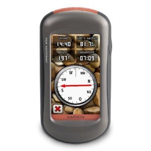
Hands on with the best Oregon yet
UPDATE: This model has been discontinued and replaced by the Oregon 600.
The Garmin Oregon 450 is one of the newest members of the touchscreen Oregon family, featuring the latest improvements such as better visibility, a tri-axial compass, custom dashboards, advanced track navigation features and the ability to load custom maps and BirdsEye aerial imagery. I’ll delve into those details shortly, but first I want to clarify the differences between the Oregon 450 and some closely…
Related units
- The Oregon 450t adds pre-loaded, 1:100,000 scale topo maps of the US to the 450’s feature set (see the next section for reasons not to spend the extra money!)
- The Oregon 550 adds a 3.2 MP geotagging camera
- Going the other direction, dropping down to the Oregon 300, you’ll go back to an earlier generation (less legible) screen and you’ll get a standard electronic compass
- To see how the Oregon 450 stands up against other Garmin models, check out my Garmin handheld GPS comparison chart.
Save your money
The 450t’s pre-loaded topo maps of the entire U.S. may appeal to those who travel a lot, but there are few other reasons to step up to that model. The reason? There are better quality 1:24,000 scale topo maps available for free for most states. GPS File Depot is a great source for such maps.
Custom maps and BirdsEye imagery
Then there is the recent introduction of Garmin custom maps. Basically, this allows you to put any map image on your Oregon. Found a park trail map online? Add it to your GPS! The image at left below shows a custom map — a USGS topo map (raster) image. You can read more about this feature by checking out my posts on Garmin custom maps.
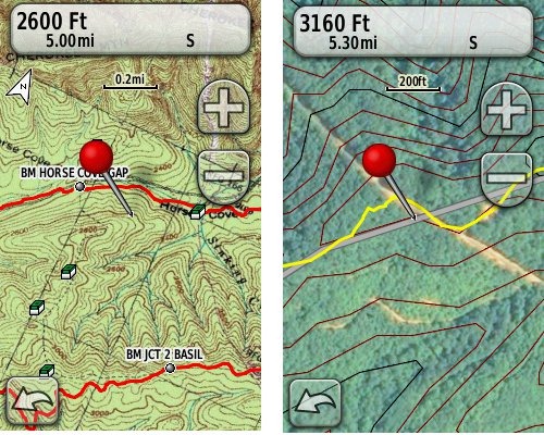 Garmin also recently announced their BirdsEye aerial imagery program, a $29.99 annual subscription that will allow you to add aerial imagery to the Oregon series. The image at right, above, shows a screenshot.
Now that we have that out of the way, lets look at some of the other new features in the Oregon line, which are all found on the 450…
Oregon 450 touchscreen display
All of the newer generation high-resolution GPS screens suffer a bit when it comes to visibility. The 550 series is slightly better than the x00 first generation, but the newer 450 series seems better yet. As a matter of fact, it’s the first Oregon I’m going to recommend for fixed mount, non-powered use, such as bike handlebars. In the past, I’ve recommended Oregons primarily for handheld use, where you will intuitively tilt it for the best view.
Let me back up a bit and share what I saw when testing the Oregon 450. The first time out on my bike, I was surprised by the visibility, but when I took the 450 off my handlebars, and held it side by side with my 400t, I couldn’t tell much difference looking at them straight on. Once I tried different angles though, it became clear to me that the 450 was viewable over a wider range than the older model. I don’t recall seeing this when I tested the 550t, so I asked Garmin if there had been changes between the 450 and 550 series in regards to screen technology. Here’s the response I got:
While the most notable enhancement in our Oregon screens was from the x00 to the x50 lineup, customers may notice other improvements that are a result of various hardware and software improvements.
The difference is seen in sunny, bright conditions only. I could not detect much difference in shade. And regardless, in at least some conditions, the 450 still isn’t as bright as older units that don’t have such high resolution screens (e.g., the 60/76C and eTrex C series). But the huge number of improvements the Oregon series is accumulating leaves me with little reservation in recommending them over previous model lines. With the recent improvements in screen technology, visibility just isn’t a deal killer, even for bikers. Even so, I still recommend that users create sun and shade profiles to improve visibility (discussed a little later in this review).
Portions of the following are taken from my Oregon 550t review.
Oregon 450 tri-axial compass
Having a tri-axial compass means you don’t have to hold the unit level while navigating. The downside is that the calibration process is more complicated than that for a two-axis electronic compass. It’s the same procedure that is used on the Dakota 20 — here’s a brief video I shot of it. The compass should be recalibrated every time you change the batteries in the unit. Like most GPS receivers with an electronic compass, the 450 also includes a barometric altimeter.
Garmin Oregon 450 Interface
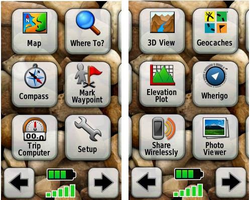
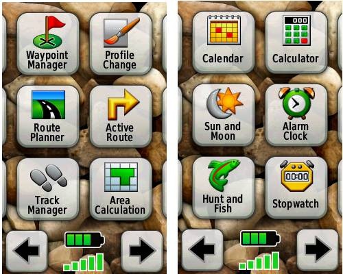
Handheld GPS receivers typically offer lots of options, and can be overwhelming for a first-time user. Even so, the Oregon is about as intuitive as they get, and I love the touch screen menus. The main menu is spread across five screens (as shown below); these can be customized, so if you don’t need “Man Overboard”, you don’t have to display it.
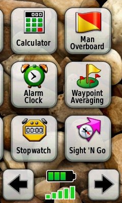
Customizing the Garmin Oregon 450
Take the time to do some additional customization and it gets even better. Here are some tips:
Use profiles – There is a “Change profiles” item on the main menu, and you can create a new one via Setup > Profiles. Tap the new profile to give it a name. Now start changing various preferences. Want track up when geocaching and north up when biking? No problem. The possibilities are nearly endless.
Rearrange the main menu – Set this different for each profile. I make extensive use of the Track Manager, so that gets moved to the first main menu screen for my hiking and biking profiles.
Create sun and shade profiles – A great use of this tool is to create separate sun and shade profiles (perhaps even one for each activity). Create a Sun profile and then go to Setup > Maps > Advanced Map Setup. Set Shaded Relief to Do Not Show to enhance visibility in bright light. If you’re in an area with lots of national parks and forest, you can also improve visibility by getting rid of the green background. Go to Setup > Map > Advanced Map Setup > Zoom Levels > Land Cover and set it to Off. Credit GPS Fix with originating these tips for sun / shade profiles.
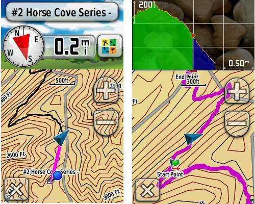
Dashboards – The map screen can be set up to show 0, 2 or 4 data fields, or to display a dashboard. Choices for the latter are recreational, automotive, stopwatch, compass, large data field, geocaching (nearest or active) or elevation plot. I’ve included screenshots showing the last two below.
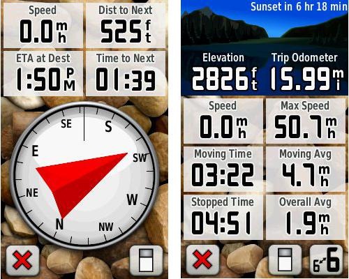
Shown below are the compass and trip computer screens. The data fields can, of course, be customized, as can the background. The trip computer screen can be also switched to show fewer (but larger) data fields. The top section of each can be modified display one of the previously mentioned dashboards.
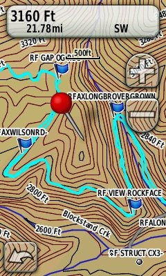
Finally, here’s a random interface tip… When you select a location on the map, a push pin appears. You can now slide the map around underneath the pin, and zoom in as needed, to fine tune the selected location..
Route, Track and Waypoint management
 The Oregon series has excellent route, track and waypoint management tools, including:
- Waypoints – The ability to project a waypoint, and to reposition one at your current location.
- Tracks – You can choose to hide or show tracks on the map and give them a custom color (17 colors are available). The image at the right shows a track in light blue (a record of a previous trip).
- Routes – You can view a map of the entire route, edit the route, reverse it and view an elevation plot.
Track Navigation
The Oregon 450 features some recent improvements in track navigation. Select a track to navigate and a route will be created. Waypoints are created for the high and low elevation points and any user waypoints along the track are added to the route. I’m a heavy user of track navigation. If I head out for a trail I’ve never traveled before, I do a search online for tracks (favorite search terms are .gpx, gps, trail name, and park name) and load the track to the device. One advantage of this new track navigation feature is that, unlike typical backcountry route navigation, you’ll get an estimate of actual trail distance rather than “as the crow flies” mileage.
Geocaching with the Oregon 450
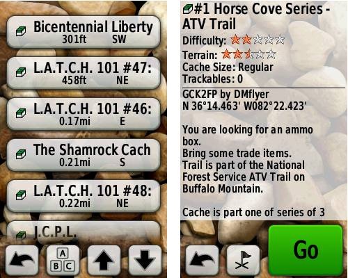
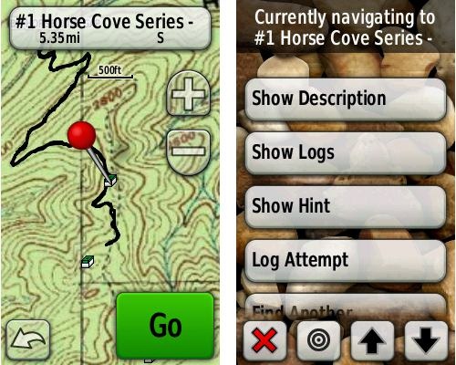
The Oregon 450 is a nice GPS for geocaching, as it is set up for full paperless support, meaning you can see the description, logs, and the hint, and you can log your attempt (find, DNF, etc.) for later transfer back to geocaching.com. Speaking of which, full access to these features requires a premium membership at geocaching.com. Shown below, clockwise from top left: Closest geocaches, geocache description, menu for a specific cache, and custom map using a USGS topo.
Wireless data transfer
The Oregon 450 is capable of wireless data transfer with other compatible Garmin units. You can transfer waypoints, tracks, routes and geocache summaries (paperless caching details cannot be transferred).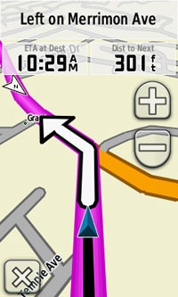
Garmin Oregon 450 in your car
The Oregon 450 makes an excellent dual-use unit, though you’ll probably want City Navigator and a car kit if you want to use it as a turn-by-turn navigator in your car. If I wanted a single unit for trail and road, an Oregon plus City Navigator (screenshot at right) would be my top choice.
Garmin Oregon 450 performance
The Oregon 450 performed very well for me in testing against multiple units including the Garmin GPSMAP 60CSx and the Magellan eXplorist GC. I noticed no significant differences in accuracy at ground zero when geocaching.
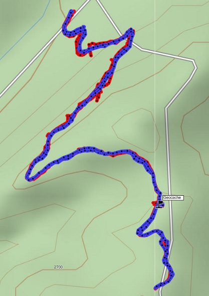
Multiple tracklogs were collected, comparing the Oregon 450 and the Garmin 60CSx. Tracking was set to collect points every five seconds while mountain biking. Steep terrain ridden in both directions, combined with frequent stops to record notes, resulted in good testing environments. In the images below, the Oregon 450 tracklog is in blue, the 60CSx is in red. I’ve compiled these four tracks in a single .gdb file, which you can download and open in MapSource or BaseCamp for closer examination.
In one test, shown below, the 60CSX wandered a bit more than the Oregon in a few spots, while the Oregon track separated more at one point on the uphill and downhill runs. This test was a draw.
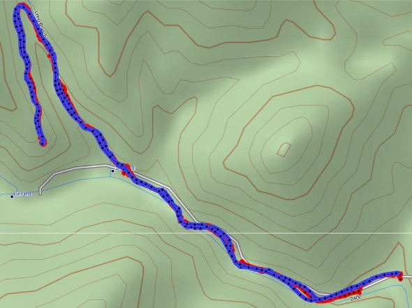
In the test below, the Oregon significantly outperformed the 60CSx. I’ve labeled a geocache at one point, because I moved around a fair bit there. Still there were two other points where the 60CSx wandered significantly. Each unit had a single instance of track separation on the uphill and downhill segments.
Battery life is rated by Garmin at 16 hours. In my testing it ranged from 10 hours, 27 minutes (backlight always on) to 16 hours, 51 minutes (backlight timeout set for two minutes, battery saver mode enabled). Battery life tests were conducted with the unit stationary, using Eneloop low discharge rechargeable batteries.
One other performance note — I’ve always been very impressed with how accurately my 60CSx reports overall elevation gain, and disappointed with the inaccurate numbers generated by my Oregon 400t. I was pleasantly surprised to see that the Oregon 450 is extremely close to my 60CSx in terms of reported elevation gain. I hope to do some more testing before I send the review unit back to Garmin, and will post a full report here.
UPDATE: Well, I set out on the trail to test this out and to my surprise, the 400t, 450 and 60CSx were all within 2% of each other. Perhaps Garmin fixed this on the Oregon x00 series in their most recent firmware update. Go figure!
Garmin Oregon 450 pros
- Tri-axial compass
- Barometric altimeter
- Great touch screen interface
- Ability to customize display and menus using profiles
- Excellent track management and routing tools
- Paperless geocaching support
- Availability of free maps
- Accepts Garmin custom raster maps
- Accepts Garmin Birds Eye imagery
- Improved visibility over previous Oregon series
Garmin Oregon 450 cons
- Somewhat poorer sunlight visibility than eTrex and GPSMAP color units
Recommendation and conclusion
Highly recommended. The Oregon 450 is a great workhorse, at a reasonable price. The interface is very user friendly and it has a lengthy feature set. It is an excellent choice for nearly any outdoor activity, including geocaching and hiking. This is the first Oregon I’m recommending for bikes too, due to the improved screen visibility, which makes it more appropriate for fixed-mount use.
More Garmin Oregon 450 reviews
- Consumer-authored Garmin Oregon 450 review
have been posted at Amazon
- More consumer reviews of the Oregon 450
have been posted at at REI.com
- A first impressions user review of the Oregon 450
- It’s Not About the Numbers reviews the Garmin 450 from a geocacher (and Blackberry user’s) perspective
I’ll be posting more hands on GPS reviews as they appear, but in the meantime, here are some…
Other Garmin Oregon 450 resources
- The Garmin Oregon 450 owners manual, in the language of your choice
- A Garmin Oregon message forum
- Use this chart to compare the Oregon 450 to other Garmin handheld GPS models
- There are links to more handheld GPS reviews in our buyers guide
- The Garmin Oregon wiki has an Oregon FAQ
- Trying to decide between the Oregon 450 and the Garmin 62 series? Maybe this will help
- Garmin Oregon training videos
- The official Garmin Oregon 450 web page
Compare prices on the Garmin Oregon 450 at these merchants:
- Check the current Garmin Oregon 450
price at Amazon
- Find the Garmin Oregon 450t at GPS City, one of our favorite low cost vendors
- Buy the Garmin Oregon 450
direct from Garmin
- Get a great deal on the Garmin Oregon 450 Handheld GPS
at J&R Computer
- Check out the deal on the Garmin Oregon 450 GPS
at REI.com, where satisfaction is guaranteed and members get 10% back on eligible purchases
- Get the Garmin Oregon 450
for an amazing price on eBay


Hi Rich, on oregon 450, when I set it to 0 data fields. Everything on the screen is cleared except for the written note that indicates the direction such as E to Bank St. is there any way to remove that off the sight too? just want to see the whole screen only thanks. I assume you have oregon 450.
Yes, I do have the 450. You might try switching out of the Automotive profile. Not sure if that will do it or not.
Hi Rich,
Thanks so much for the great site – it’s by far the most useful GPS resource I have found.
I have a question on battery life. This spring/summer I’m going to take a 2 1/2 month backpacking/photography trip, and I’d like to geotag my photos. I’d also like to be able to occasionally use a GPS device for its mapping features (as opposed to a dedicated geotagging device). Do you have a rough idea of what the battery life of the Oregon 450 would be if spent purely in tracking mode (with whatever the maximum tracking interval is)? Do you know how this would compare to the DeLorme PN-60? I don’t see myself using the GPS for its maps more than once or twice a day, and I can turn off the compass and any auxiliary features. I’ll be out on the trail up to a week or so at time, so I’d really like to not have to carry a set of batteries for each day on the trail!
I figure if the Garmin/DeLorme devices don’t last long in tracking mode, I can just use paper maps and pick up a geotagging device (I found one which claims 42 hours runtime). But as a technophile, the Oregon 450 looks like quite a nice piece of gear (and a steal at $250 at Cabela’s right now).
Thanks!
Justin
I’m not sure either unit will give you that great of battery life. You can probably expect 10-14 hours. Lithium would give longer life of course. A data logger will likely do much better. I haven’t researched them much, but I wonder about a solar charger. If a pair of AAs would recharge over the course of a day, you could swap out each day.
I appreciate the feedback. The solar charger is an interesting idea, certainly worth looking into. Thanks!
I’d love to hear what you turn up in that regard.
The best backpacking solar charger that I’ve found is the GoalZero Nomad 7. It weighs a little less than a pound and apparently can charge most phones with 1-2 hours of sunlight (strong sun, I’m assuming). It can charge a device directly if that device allows direct charging (I don’t believe the Garmin Oregon does), or it can charge the GoalZero Guide 10 AA/AAA battery pack, which is sold separately. The Nomad 7 has loops that let you strap it to a backpack/tent/whatever else you might want to secure it to.
All that said, in my case it seems like a lot of complication when the alternative is to just pack some extra batteries!
http://www.goalzero.com/shop/p/11/Nomad-7-Solar-Panel/3:1/
http://www.goalzero.com/shop/p/8/Guide-10-Battery-Pack/4:1/
(these are available for less money elsewhere!)
I recently ordered an Oregon 450 from Cabelas for $250 as well. I was wondering if anyone has used any of the marine-type maps with this (or any) device. This will be my first hand-held GPS, so not sure on all the capabilities until i sit and play with it- should be coming home from Afghanistan in June and will play with it then.
I am planning on using it to go fishing as well as hiking and wondered what experiences any have had with the lake maps. How detailed are they maps and do they change with the water level changes. i ask because i would use it at Lake Powell, where the water level fluctuates depending on the season.
Thanks for the great info here. i plan to use this site a a resource as i learn about all the fun things to do with GPS.
Great question, but I stick solely with terrestrial adventures and can’t say. I know they show bathymetry data though. You might want to ask here…
http://www.thehulltruth.com/marine-electronics-forum-19/
Thanks Rich. I’ll post a link here if i find anything there or elsewhere on the subject for anyone else who is interested.
I have the Northeast Inland Lake maps..they show the depths with contours, boat landing, gas locations, nearby streams and islands…I live in northern Maine so the lakes are out in the boon docks… I used my 450 for ice fishing and ATV rides..I bought it at LL Bean this winter for $79.00..it was the card chip…dated 2009..must of been an older stock item..but it works for me. I also used the Topo chip as mentioned above when I ride in the woods with my Atv..very happy with this one…got me out of the woods several times I got turned around..make sure you switch on the “most details” in your set-up window.
I have a Garmin Oregon 450. I am have downloaded maps from google earth (KMZ files). When I plug my garmin into the computer they appear to be on the Garmin system. However, I am not able to view them on the garmin when it is not plugged into the computer. Any ideas?
The only way to use .kmz files in this manner is for making a custom map. They would need a .jpg image file associated with them. The basic process is outlined here…
http://garmin.blogs.com/softwareupdates/2009/10/creating-and-using-garmin-custom-maps-in-five-easy-steps.html
though there are other tools available that make it easier. I’ve got a bit more info here…
http://gpstracklog.com/tag/garmin-custom-maps
Hi Rich, if you use your oregon 450 in your car, what kind of mount would you suggest? Oregon is a small gps, some mounts r very big. what is your experience? also the slip case? any opinion on this? http://www.amazon.com/Garmin-010-11345-00-Slip-case/dp/B001ULDANC
thanks
I haven’t used the slip-case, although some folks seem to like them. In the car, I’d use the Garmin stock mount (https://buy.garmin.com/shop/shop.do?pID=15428) — though the price is ridiculous. I’d combine it with a friction dashboard mount, which I already have.
I went to the GPS file depot and was looking at downloading some maps for my Oregon 450. Is Mapsource required to download these maps to my gps? If so, is this something that needs to be purchased from Garmin??
It’s probably the most straightforward way to install them. You can get it for free…
http://www.gpsfiledepot.com/tutorials/how-to-install-mapsource-if-it-didnt-come-with-your-gps/
Unfortunately, when you go to that link, it brings you to the Garmin site. It is where you would go to update your version of Mapsource. Since I don’t have Mapsource, it will not allow you to continue downloading. I’m thinking my cheapest option is to buy a cheap map from Garmin as it would include Mapsource. Then once Mapsource is had, gpsfiledepot.com is a great site for other free maps.
If you’ll follow the directions (install Training Center first) it should work. Quite legal too, BTW.
Hi Rich, when you use auto charger in the car,the one you suggested me with the mount, does oregon ask you what to each time you plug it in? with normal usb cable, you know oregon gives power or storage options. and you choose the one you want when the unit is set to spanner mode.
and while oregon is plugged in in the car, if you shut off the engine what is Oregon’s response? thanx
No, but you may be able to change this behavior by putting it into Spanner mode (see P9 at http://garminoregon.wikispaces.com/Power).
I’m not sure what happens when you turn it off. You may want to ask at http://garminoregon.wikispaces.com/message/list/home
I need to order a car kit myself, but have been putting it off due to the outrageous cost!
I am thinking of getting it for dual use when hiking or on my road bike. Didn’t you mention you used it on your bike? I had a 60CSX I tried to use on the bike but the battery kept jiggling and going off.
Yes, but I prefer the 62 series, since its easy to change screens on the fly without looking at the unit. This might help…
http://gpstracklog.com/2010/07/garmin-gpsmap-62s-or-oregon-450.html
I should add that the batteries are held tighter in the 62 series than in the 60CSx.
@Justin – Thanks for sharing that. I dunno — if you’re going to be out for 2-1/2 months, it may be worth the hassle. That’s a lot of batteries to carry!
True enough! It’s just that my 2 1/2 month trip will actually be composed of several shorter (3-8 day) backcountry outings with car (and therefore charging) time in between. I feel like carrying 8 sets of AAs (at a weight of slightly under one pound) might make more sense than rigging up a solar charging system that I could (hypothetically) destroy when I (hypothetically) slip and roll down a 200 foot shale hill into a group of angry bears. Come to think of it, I might want to look into bear spray and a good medical kit…
But in all seriousness, thanks again for the site. I think I’m going to pull the trigger on the 450!
Ah, I see. Makes perfect sense. The 450 is a great unit; I think you’ll be pleased.
Have fun on your trip. Sounds awesome!
Hi Rich, on oregon 450 auto mode I could not figure out the data field that shows direction of the next turn. Is there such a thing? There is one called pointer, which serves another purpose. There is one called ‘turn’. Maybe that one, but it shows only some numeric degrees. All I need is a pointer that shows direction of the next turn. any suggestion? thanks
Not that I know of. I assume you have the automotive profile enabled. I can check it this weekend and see.
Yes it is enabled. and I have city N installed. When I choose ‘turn’ in the data field, it does not show any pointer for the direction of the next turn but something else that I don’t know. wish there was a good guidebook available for 450. this data would be very handy before approaching the next turn on road.
check out this link and look for ‘turn’. it tells what it does. not sure if this is a reliable source tough. thanks
http://www.tramsoft.ch/gps/garmin_oregon300_en.html
Yeah, I think “Turn” is only going to show bearing.
You should be seeing something like this as you near a turn, but it sounds like you want more advance notice…
all I want is, like on regular car gps, you make a turn and then on the top I would like to see the direction of the turn with a pointer so that I could make the lane change in advance. it is possible to see the turn on the map but the pointer would be useful. normal many car gps have this pointer.
I bought the Oregon 450 for paperless geocaching. So far, so good. My question is, can you delete caches after you have downloaded them into the gps? I downloaded the manual and I cannot find my answer. After a day of caching I would like to be able to see just the finds I have for that day. Otherwise they are in order of location nearest my home and I have to scroll through them to remember which ones I need to log on geocaching.com. Thank you.
The only way to delete them is to delete the .gpx files…
http://garminoregon.wikispaces.com/Geocaching (see GC9)
GC11 on the same page should show you an easy way to log your finds.
Thank you for sending in the right direction. This site should answer a lot of my questions.
I found the plastic cover very bad on the slip case. it is very tick and the screen is not sensitive under this cover. I followed what it is said in some forum discussions. Very pleased. Rich, how can I put a photo here?
I don’t think my platform allows you to upload a photo directly, but you can link to one you’ve put on Flickr, etc.
I see. please let me know about the data field thing that I asked you about. hope there is something that shows the direction of the next turn in advance on automotive mode. also is there a good third party guidebook that you can suggest. there are a lot of info in data field. I have no idea about some of them. thanx
Okay, I loaded some Garmin routable maps and can verify that this option does not exist.
While this site is about the Oregon series, the OS is basically the same (just buttons on the 62 series instead of touchscreen)…
http://garminoregon.wikispaces.com/
I suggest you check it out. Its got a wealth of info.
I just got my Garmin Oregon 450. I installed the batteries and everything seemed fine. Now when I hook it up to the Computer all I see is the name “Garmin” and a picture of the GPS connected to a computer. Help Please
It’s in mass storage mode. Open Windows Explorer and find the Garmin drive if you want to add GPX files to it.
When done (assuming you’re on Windows), there should be an icon in the system tray that says something like “safely eject hardware.” Click there, find the Garmin in the little window that opens up, and click again to eject it.
Thanks for your comment.
I am using a Mac, so I’m not sure what to do. All I see when I connect to the computer is the name and picture described above. I looked at the Geocaching forums and there is a discussion of the same problem. The problem as I can see it appears to be a defective unit.
Thanks again.
Can you see it in Finder under Devices and eject it? If you can, everything you’re describing is normal behavior.
OK.
My confusion stems from the fact that when the Oregon is connected to the computer I only see, as noted above the Garmin name and icon. I can download a cache but have to disconnect from the computer to view it, or anything else. Whereas, this is not the case with the 60CSX.
But, you are telling me this is normal.
Thanks again
Exactly. The Oregons go into mass storage mode automatically, whereas the 60CSx does not.
don’t think your oregon is defective. if it was it would not work with the batteries. Rich’s suggestion should work like a miracle. work with the options, you will be fine.
I have an iMac and when I connect the Garmin (with no Garmin software running on the Mac) I get a message on the GPS saying “USB Cable Detected, Would you like to go to Mass Storage?” and and “Yes” and “No” button. When I select Yes the GPS shows up in the Finder.
that is a good sign. choose the one you want. if you want to add data you have to choose yes, if you just want to power the unit choose ‘no’. you also need to install the gps software to add data to the unit or the card. is your unit working on batteries no problem right?
The unit appears to be working fine with just the batteries. When I connect to the Mac I do not get the message “USB Cable detected….” and the Garmin icon shows up on the desktop so the computer knows it is there. To repeat I only see the Garmin name and a picture on the GPS. It’s a little late I’ll call Garmin tomorrow and see what they say. Thanks.
Incidentally, I had no problem with the GPSmap 60CSx using the same computer. I did want to get a unit that does paperless caching
With your GPS Not connected to the computer.Turn your GPS on,and from the menu,go to Set Up,in Set Up,go to System.Now check that the Interface is set to Garmin Spanner, if not, set it to Garmin Spanner.Now go back to Main Menu and turn off your GPS.Plug In your USB Cable.Now you will have option of going to mass storage or not.
Hi Rich, yesterday while i was passing through a tunnel in my car, oregon450 lost signal. After the tunnel map was still showing what I saw seeing before entering tunnel. it just froze there. but i was able to move the map with my fingers, so the unit was giving response. It never locked back on signal automatically after the tunnel. I waited for like 3-4 min. nothing. it was saying weak signal even though the area was wide open. has this ever happened to you?
also, when the unit lost signal, a test appears on the screen saying ‘lost satellite reception’ and a button ‘OK’
when you are driving, if this happens, do you click on OK or does the unit lock on satellite automatically when it gets enough signal. thanks
yesterday though that text did not appear, it was just saying ‘weak signal’
i just did a quick test, the unit locks on the signal automatically. please disregard my second question.
I haven’t seen that, but sometimes weird things happen with about any unit out there.
In my experience, it is harder for a unit to lock satellites if you’re in motion. That could have been at play. Was it a long tunnel?
speaking of batteries. Do you use eneloop batteries or batteries with much higher capacity on 450?
it was just 10 sec. very short. I will look into that if i am driving through a tunnel. as a small note: this unit really eats up the AA very fast:) it is definitely not an issue for me though!
Are you using rechargeables? You’ll get very poor performance with alkalines.
I am happy with Duracell 2650mAh. a pair is good for a day if I am using the unit like crazy, I mean everything is on. But alkalines are 1.5 v. I though they were better than rechargeable. I used once they seemed to last longer to me. I do not use them just due to cost.
Yeah, I use Eneloops.
Can you tell me about the garman oregon 450t. What I want to know is because it comes with preloaded maps if I want to load some other types of maps from this site do I have to first remove the originals, or can I switch between the two maps.
No, you can switch between the two. Unless you travel across the country quite a bit, the 450 may be a much better deal though.
Thank you
I got the 450. The clerk at the store cannot belive that you can download topo maps for free. A bit hard to believe for me too. I went to the website you called out and got Colorado on my computer and am now going to try to download it. I was told not to go bigger than a 4 gigabite card, makes it too slow. Does it switch between maps like choosing a document on on the computer? I am trying to decide if i should buy multiple chips or one large one.
Your websit is the best I have ever seen, thanks for the information
Larger cards shouldn’t slow it down except for startup and profile changes. There are people using 16GB cards without problems.
You can switch maps by going to Setup > Map > Map Information.
Out of curiosity, is gps technology on iphone as reliable as handheld gps? I don’t have an iphone but wondering what it can and it can’t do in terms of navigation as compared to say oregon?.
other thing that i am wondering is whether or not iphone’s gps feature works in remote areas where there is no phone signal?
I know this is not a forum for iphones but thought you or someone might have some reliable info. thanks
I’m not an iPhone user, so can’t address that specifically. I understand that the iPhone 4 is much better than previous generations. Using the Motorola Droid, I’ve found that it can be difficult to get a GPS lock in areas without cellular signals. There are other issues as well – smartphones aren’t ruggedized or waterproof, and battery life can be poor, especially if its searching for a signal where there isn’t one.
thanks…
Hi!
I recently used my cousin’s 450 for the first time while out hiking in the mountains, following a track I downloaded from WikiLoc. It was fantastic, especially when compared to my old GPSMAP 76.
My cousin also showed me some urban area maps he had downloaded from OpenMapSource. I thought about my friends with iPhones who use them to navigate foreign cities while traveling. Can the Oregon 450 be used like this in an urban setting? Can it give directions to street addresses, or at least to points on an OpenMapSource map? It would be an amazing feature. My ‘iPhone friends’ need to pay data fees to use their maps with GPS. With the Garmin, the maps could be pre-downloaded.
Also, before I go out to buy a 450 for myself, I thought I might ask if there might be a model upgrade out soon. The 450 has been available for over a year now.
Thanks! Great review, great site.
Marcus
Yes, you can use the Oregon for that purpose. You can navigate to points on an OSM map or to an address on City Navigator maps.
Great question on an updated Oregon. I’m expecting some new releases this spring, but most likely that will be an updated eTrex line. The one thing we might see re: Oregons is one with 24K and highway maps preloaded for the entire US. But those are just guesses.
Thanks for the reply!
If the next generation Oregon gets Advanced Pedestrian Mode, I think it would be the ultimate travelers GPS. The Garmin 3xxx (etc.) units are very sexy and could be great for urban exploring, if only they had 12 hour batteries, or could take AAs.
Keep up the great work.
Marcus
What do you have in mind when you say advanced pedestrian mode?
Sorry, my mistake. I didn’t mean ‘Advanced’, but ‘Enhanced’ pedestrian navigation. I think the Oregon would be the ultimate travelers tool if it included the same functions that the newer Garmin 1xxx, 2xxx and 3xxx units have which can be used in conjunction with the ‘enhanced’ CityXplorer maps. I haven’t tried these systems out, but I think it would be great to have pedestrian navigation which incorporated bus/subway/rail connections.
I travel in European cities a lot. For me, smartphone-based off-board navigation is far too expensive to use a lot while roaming. I actually considered upgrading my relatively new in-car Nuvi 765T to one of the newer units, but the four hour battery life is just not suitable for traveling in an urban area without a car over several days.
Marcus
Hi Rich, when I unplug oregon 450 from laptop (current at spanner mode), a count down starts and ask if I want the unit stay on or turned off. Is there anyway to skip this by changing some the the settings. When I unplug it from the external power source such as a laptop, I want oregon to continue to use the internal batteries already installed without asking me what to do. Is that possible? thanks
I don’t think so.
@Marcus 68 – I thought that might be what you meant. Yes, it would be nice to see CityXplorer compatibility i n their advanced handhelds.
Here is the oregon slip case thing:
http://accessoriesforoutdoorlife.blogspot.com/2011/04/oregon-slip-case.html
I currently have a Garmin Vista cx – I am looking to upgrade and am trying to decide between upgrading to the Vista Hcx or the Oregon. Thoughts? Thanks.
I would definitely go with the Oregon. You’ll get improved track navigation, the ability to add Garmin custom maps and birds eye aerial imagery, a much improved interface and paperless geocaching capabilities.
I just bought an Oregon 450 at Staples for $189 with free one-day shipping. Just go to staples.com and search for Oregon 450. Hurry before they figure out it’s a mistake.
Thanks Cap. I posted the link at http://bestgpsdeals.net/garmin-oregon-450-for-189-99/1136/.
rich, when I download my tracks and waypoints after a hike, sometimes the AEG from this is not particularly close to the number from the Plot Elevation> NOthing jumps out of the owner’s manual as to why this should be. Today the download showed AEG of 4416 feet while the plot elevation said 5868 feet. They appear to be measuring the same hike??? Thanks for your thoughts.
I’ve experienced problems with elevation gain numbers myself. It seems like its broken, then a firmware upgrade fixes it, then it gets broken again with the next update. The number I look at is total ascent on the altimeter page. I always reset everything before the start of a hike. I’d suggest trying it out on a hike that is all uphill, with no ups and downs, where you can pretty accurately estimate elevation gain from a topo map. At the end (before heading back home), note the total ascent number. Compare that to the track elevation once you get home. If the Oregon is working properly, the total ascent figure should be the most accurate.
Rich, I include a link to a site showing barometric air pressure and elevation changes http://www.engineeringtoolbox.com/air-altitude-pressure-d_462.html
which roughly says, at my hiking altitude, that a simple low pressure system moving through the hiking area, and dropping the pressure by 1″ of mercury, will raise the elevation reading 1000′ on the barometric altimeter. I have, with heroic assumptions about the speed of change, calculated that this is what caused the 1452′ discrepancy in my readings. So, when I know in the future that a front is coming through, or even if I don’t, I should take air pressure readings from time to time while I’m hiking, or reset the altimeter periodically during the hike. We had a 2″ drop in the mercury that day.
Or not hike during changing weather! 😉
Seriously though, that’s some good detective work!
Hello Rich,
Quick user update on my well-used Oregon 450, regarding its waterproofness.
I did some road biking yesterday and got caught in a moderately heavy downpour. My Garmin 450 was mounted on the stem of my handlebar, its usual position when I’m biking.
When I got home I noticed that I hadn’t closed the flap covering the USB port in the bottom. I plugged the connector cable in as usual and tried to download the ride. However, the Garmin 450 then gave me a brief message I’d never seen before–something about it’s not being recognized–and the unit then presented the normal use screen instead of the image associated with data tranfer.
Looking at the USB port area, I noticed fine beads of water. I opened up the cover and blew out all the water from around the USB port area, feeling little droplets flying out as I did so. Since the unit was still working I figured that the water had created some sort of short across the USB contacts, causing the fault. It still wouldn’t connect properly, so I let it sit overnight. This morning it connected for downloads just fine.
To me, this was yet another proof of how rugged this little beast is. But from now on I’ll be sure to seal the USB port area when I’m riding.
Thanks for sharing. When you say you opened up the cover, did you just open the battery cover, or did you undo the screws under it? Just curious.
Hi Rich, I only opened the battery compartment’s cover. Nothing special.
Gander Mtn. has the Oregon 450t on sale this week for $299 (including a $75 mail-in rebate). Is there any downside to getting the 450t vs the 450? Sounds like having the topo maps installed may be a plus. Thanks.
No downside. That’s a pretty good deal. The 450t includes 1:100K topos, and you can get better 1:24K topos for free from http://gpsfiledepot.com, but if you travel a lot, its really nice to have the preloaded ones.
I do have the Garmin US Topo National Parks 24K series – which I plan to load on the 450t. Would I have to switch mapsets when I go into a National Park or would the 450t automatically switch to the 24K map?
Looks like the promo code GMG20 will get you an additional $20 discount. Also, thanks for the tip. I just posted it to my deals site: http://bestgpsdeals.net/garmin-oregon-450t-for-279-99/1150/
I picked up the 450t at the local Gander Mtn. store this afternoon. When I checked the GM web site the 450t was on backorder until 5/30. That wouldn’t have been a problem but the rebate was only good for register receipts 5/15 to 5/21. I could have used the promo code on the web site but I couldn’t use it in the store. Thanks for your help.
You would need to switch them, but it’s pretty easy to do by going to Setup > Map > Map Information/Select Map. Or you could create a profile for 24K maps to make it even easier.
On a recent trip i nearly run out of batteries my Garmin 450T. Is there a way to save the track, shut off the device change batteries then restart another track and stitch them together ?. I cannot seem to work it out, under basecamp i cannot find anything to help me.
Sorry forgot to add i wish to see Both track as one seamless Track.
I have been able to join two tracks together using BaseCamp. I select both tracks and right click. One of the options is to join the tracks.
DavidB
Many thanks DavidB, now sorted.
If you’re using Windows, you might want to try the TopoFusion demo. It would see and import those as a single track, and give you Merge and other options on the import dialog.
can someone tell me how i could create owner info at start up on oregon 450? where should I type the info? can/should I also type an address? or just phone number? how long can the text be?
also are there alternative locations to display that info? maybe a anywhere except start up display? thanks
This should help…
http://garminoregon.wikispaces.com/message/view/home/13279991
Love your review of the 62s vs. 450. I’m debating between the two for hiking / mtb. Your point is well taken about the 62s being easier on the bike, but I’m bedazzled over size and weight of the 450. Think I’ll see if GM has one at my store tomorrow (the 450t on sale). Thanks for the great review!
Watch for my post tomorrow morning before deciding. 🙂
Ahhhhh…. the saga continues! 😉 I’ll gladly wait, as I’m totally torn between the two.
You’ll be interested to know there is a new version of the software available through WebUpdater: 4.50.
http://www8.garmin.com/support/download_details.jsp?id=4523
Paul
Thanks Paul. I’ll add it to my link roundup this weekend.
Question regarding durability. Clearly the Oregon 450 is an upgrade from a stalwart like the 60cxs, but is it as durable when mounted on say a dirtbike where the vibration and jarring impacts can be severe over time. I do a lot a trail riding and this is a primary concern of mine. On REI website where I was shopping a review questioned durability/was dissatisfied.
Thanks,
John
I haven’t heard of any durability issues with the Oregon series. Interestingly enough, the Oregon 450 screen is recessed, while the 62 series isn’t, which may make the former more durable!
I was looking at the DeLorme 60 but after the review (most significantly the propritary cable) I am looking at the Oregon 450.
I am currently using the Magellan eXplorist GC exclusivity for geocaching and thing things I don’t like are the joystick, the “You are now 8800 miles away” bug, the lack of a true compass (i.e. heading must be tracked by walking a direction) and its accuracy.
Topo maps are great, but satellite imagery would be nice also (hence why i was looking at the DeLorme). A useable compass would be a must also (heading). Using a standard USB cable (or bluetooth) is mandatory since I lose cables.
A camera would be nice, but not a necessity.
As someone who uses a GPS 99% for geocaching, 99% for hiking, is this the 450 a right fit?
Yes, I think its a very good unit for those uses. The other one I’d look at is the Garmin 62s, but you’re likely to find the Oregon for less money.
Is there a way to download 2 or more mapsets to the Garmin 450 data card? I downloaded the NE Topo 24K mapset using MapSource and then tried to add the National Parks Topo East mapset also using MapSource and it overwrote the NE Topo 24K mapset. Thanks.
Yep…
http://gpstracklog.com/2011/05/loading-multiple-maps-to-garmin-devices.html
When I set the altimeter to
auto calibration off
barometer fixed (i entered elevation manually)
plot type barometric pressure
and go back to elevation scree, elevation changes although I am not moving. why? Is this normal? Right now, all I need is to track the barometric changes, as my elevation is fixed. any input appreciated. thanks
I’m not sure. I recall seeing reports that squeezing the case can cause changes in pressure to register.
Very useful site, thanks for all the info. I live in florida and was flying to Colorado next week for hiking. Was gonna buy the Oregon 450, cause the reviews have pretty much sold me on it. Being that I’m Florida and will use it much more down here. I’m interested in making this unit my coord saver for all my dive spots when I go on the boat. Would this unit be good for just inputting coordinates and it will take me directly to that spot. There’s always a gps on boat however I’m wanting it so I, first have a back up in case needed, but also to start saving all my favorite dive spots. The accuracy is very imporant cause you always want to anchor directly over the ledge, or wreck..etc… Thanks
Yes, it will work fine for that. On the open water, I would expect accuracy of at least 20-30′. It could be as good as 10′ or less though. IMHO the Garmin 78s is one of the most accurate units out there now, probably better than the Oregon 450.