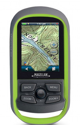
Sunday, March 18, 2012

Magellan eXplorist line gets USGS topos via National Geographic

Magellan has extended their ongoing partnership with National Geographic, bringing USGS raster topo imagery to the eXplorist line. Just like Garmin’s BirdsEye Topo, this will be a subscription option running $29.99 per year.  read more

Topo.com goes away, takes SuperQuads with it

Late last week I received an email from National Geographic Maps, informing me that their Topo.com website would be discontinued in 30 days, as they transtion to a new partnership with AllTrails.com. The National Geographic Topo desktop software will continue to work, although it is unclear if new updates will be forthcoming or not. This appears to primarily affect Magellan Triton users who have purchased Topo SuperQuads. If that’s you, you should read the info below and save those files to your hard drive over the next few weeks. read more

Satmap Active 10 TREK review

Satmap Active 10 TrekThe Satmap Active 10 TREK has finally come to the US, four years after its introduction in the UK. And what a difference four years makes. We didn’t have touch screen Oregons then, and super-thin iPhones and GPS receivers with raster imagery were just starting to be seen. But in 2011, the Satmap is reminiscent of the tech of yore, feeling more like a clunky PDA than a cutting edge piece of gear.

read more

Satmap Active 10 Trek comes to US

Satmap Active 10 Trek

UPDATE: I’ve posted my hands on review of the Satmap Active 10 TREK.

The Satmap Active 10 is finally coming to the US this week, as the Satmap Active 10 Trek. National Geographic is partnering with Satmap to offer TOPO! state series maps, Adventure Maps and Trails Illustrated maps. The unit will include a basemap, but I expect that most users would want to add some of these other options, which could make this one expensive unit, since the maps will retail for $99.99 each, on top of the $369.99 for the unit. Lets see, that’s a hundred bucks for the Carolinas, another hundred for an upcoming trip to California, and I can’t stay away from Utah. Sorry guys, raster imagery is nice, but unless I’m misreading this, your map pricing model is DOA.

read more

National Geographic TOPO price slashed in half

NG TOPO detail National Geographic has announced that they have cut the price of their TOPO State Series product in half, to $49.95, giving you every USGS topo map for your state or region for a pretty amazing price. IMHO, this is the best product out there for producing printed maps showing your waypoints and tracks. It’s essential that you carry a paper map when entering the backcountry, and this software allows you to layer the same data that’s on your GPS and focus on the exact area you plan to traverse.

read more