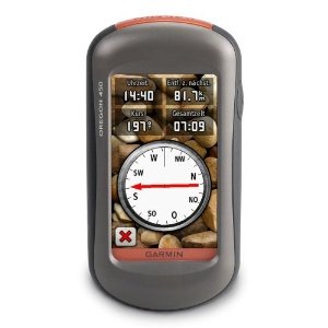
Hands on with the best Oregon yet
UPDATE: This model has been discontinued and replaced by the Oregon 600.
The Garmin Oregon 450 is one of the newest members of the touchscreen Oregon family, featuring the latest improvements such as better visibility, a tri-axial compass, custom dashboards, advanced track navigation features and the ability to load custom maps and BirdsEye aerial imagery. I’ll delve into those details shortly, but first I want to clarify the differences between the Oregon 450 and some closely…
Related units
- The Oregon 450t adds pre-loaded, 1:100,000 scale topo maps of the US to the 450’s feature set (see the next section for reasons not to spend the extra money!)
- The Oregon 550 adds a 3.2 MP geotagging camera
- Going the other direction, dropping down to the Oregon 300, you’ll go back to an earlier generation (less legible) screen and you’ll get a standard electronic compass
- To see how the Oregon 450 stands up against other Garmin models, check out my Garmin handheld GPS comparison chart.
Save your money
The 450t’s pre-loaded topo maps of the entire U.S. may appeal to those who travel a lot, but there are few other reasons to step up to that model. The reason? There are better quality 1:24,000 scale topo maps available for free for most states. GPS File Depot is a great source for such maps.
Custom maps and BirdsEye imagery
Then there is the recent introduction of Garmin custom maps. Basically, this allows you to put any map image on your Oregon. Found a park trail map online? Add it to your GPS! The image at left below shows a custom map — a USGS topo map (raster) image. You can read more about this feature by checking out my posts on Garmin custom maps.
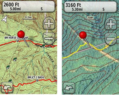 Garmin also recently announced their BirdsEye aerial imagery program, a $29.99 annual subscription that will allow you to add aerial imagery to the Oregon series. The image at right, above, shows a screenshot.
Now that we have that out of the way, lets look at some of the other new features in the Oregon line, which are all found on the 450…
Oregon 450 touchscreen display
All of the newer generation high-resolution GPS screens suffer a bit when it comes to visibility. The 550 series is slightly better than the x00 first generation, but the newer 450 series seems better yet. As a matter of fact, it’s the first Oregon I’m going to recommend for fixed mount, non-powered use, such as bike handlebars. In the past, I’ve recommended Oregons primarily for handheld use, where you will intuitively tilt it for the best view.
Let me back up a bit and share what I saw when testing the Oregon 450. The first time out on my bike, I was surprised by the visibility, but when I took the 450 off my handlebars, and held it side by side with my 400t, I couldn’t tell much difference looking at them straight on. Once I tried different angles though, it became clear to me that the 450 was viewable over a wider range than the older model. I don’t recall seeing this when I tested the 550t, so I asked Garmin if there had been changes between the 450 and 550 series in regards to screen technology. Here’s the response I got:
While the most notable enhancement in our Oregon screens was from the x00 to the x50 lineup, customers may notice other improvements that are a result of various hardware and software improvements.
The difference is seen in sunny, bright conditions only. I could not detect much difference in shade. And regardless, in at least some conditions, the 450 still isn’t as bright as older units that don’t have such high resolution screens (e.g., the 60/76C and eTrex C series). But the huge number of improvements the Oregon series is accumulating leaves me with little reservation in recommending them over previous model lines. With the recent improvements in screen technology, visibility just isn’t a deal killer, even for bikers. Even so, I still recommend that users create sun and shade profiles to improve visibility (discussed a little later in this review).
Portions of the following are taken from my Oregon 550t review.
Oregon 450 tri-axial compass
Having a tri-axial compass means you don’t have to hold the unit level while navigating. The downside is that the calibration process is more complicated than that for a two-axis electronic compass. It’s the same procedure that is used on the Dakota 20 — here’s a brief video I shot of it. The compass should be recalibrated every time you change the batteries in the unit. Like most GPS receivers with an electronic compass, the 450 also includes a barometric altimeter.
Garmin Oregon 450 Interface
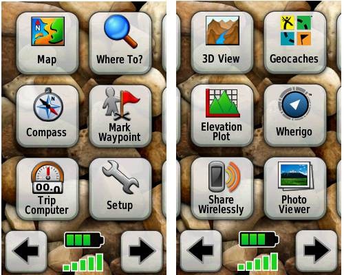
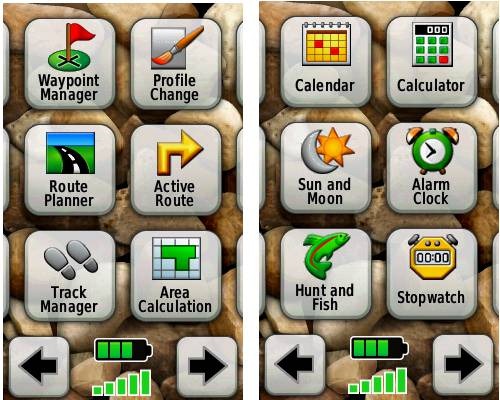
Handheld GPS receivers typically offer lots of options, and can be overwhelming for a first-time user. Even so, the Oregon is about as intuitive as they get, and I love the touch screen menus. The main menu is spread across five screens (as shown below); these can be customized, so if you don’t need “Man Overboard”, you don’t have to display it.
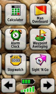
Customizing the Garmin Oregon 450
Take the time to do some additional customization and it gets even better. Here are some tips:
Use profiles – There is a “Change profiles” item on the main menu, and you can create a new one via Setup > Profiles. Tap the new profile to give it a name. Now start changing various preferences. Want track up when geocaching and north up when biking? No problem. The possibilities are nearly endless.
Rearrange the main menu – Set this different for each profile. I make extensive use of the Track Manager, so that gets moved to the first main menu screen for my hiking and biking profiles.
Create sun and shade profiles – A great use of this tool is to create separate sun and shade profiles (perhaps even one for each activity). Create a Sun profile and then go to Setup > Maps > Advanced Map Setup. Set Shaded Relief to Do Not Show to enhance visibility in bright light. If you’re in an area with lots of national parks and forest, you can also improve visibility by getting rid of the green background. Go to Setup > Map > Advanced Map Setup > Zoom Levels > Land Cover and set it to Off. Credit GPS Fix with originating these tips for sun / shade profiles.
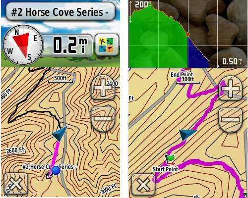
Dashboards – The map screen can be set up to show 0, 2 or 4 data fields, or to display a dashboard. Choices for the latter are recreational, automotive, stopwatch, compass, large data field, geocaching (nearest or active) or elevation plot. I’ve included screenshots showing the last two below.
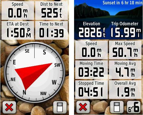
Shown below are the compass and trip computer screens. The data fields can, of course, be customized, as can the background. The trip computer screen can be also switched to show fewer (but larger) data fields. The top section of each can be modified display one of the previously mentioned dashboards.
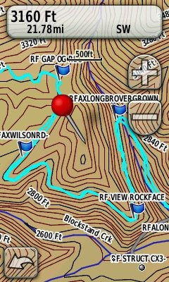
Finally, here’s a random interface tip… When you select a location on the map, a push pin appears. You can now slide the map around underneath the pin, and zoom in as needed, to fine tune the selected location..
Route, Track and Waypoint management
 The Oregon series has excellent route, track and waypoint management tools, including:
- Waypoints – The ability to project a waypoint, and to reposition one at your current location.
- Tracks – You can choose to hide or show tracks on the map and give them a custom color (17 colors are available). The image at the right shows a track in light blue (a record of a previous trip).
- Routes – You can view a map of the entire route, edit the route, reverse it and view an elevation plot.
Track Navigation
The Oregon 450 features some recent improvements in track navigation. Select a track to navigate and a route will be created. Waypoints are created for the high and low elevation points and any user waypoints along the track are added to the route. I’m a heavy user of track navigation. If I head out for a trail I’ve never traveled before, I do a search online for tracks (favorite search terms are .gpx, gps, trail name, and park name) and load the track to the device. One advantage of this new track navigation feature is that, unlike typical backcountry route navigation, you’ll get an estimate of actual trail distance rather than “as the crow flies” mileage.
Geocaching with the Oregon 450
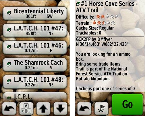
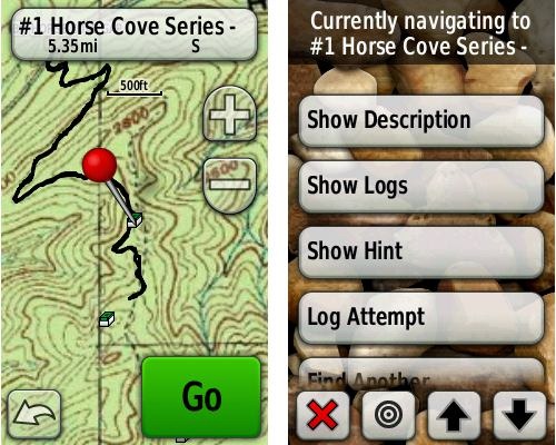
The Oregon 450 is a nice GPS for geocaching, as it is set up for full paperless support, meaning you can see the description, logs, and the hint, and you can log your attempt (find, DNF, etc.) for later transfer back to geocaching.com. Speaking of which, full access to these features requires a premium membership at geocaching.com. Shown below, clockwise from top left: Closest geocaches, geocache description, menu for a specific cache, and custom map using a USGS topo.
Wireless data transfer
The Oregon 450 is capable of wireless data transfer with other compatible Garmin units. You can transfer waypoints, tracks, routes and geocache summaries (paperless caching details cannot be transferred).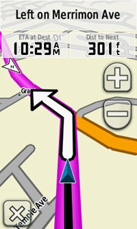
Garmin Oregon 450 in your car
The Oregon 450 makes an excellent dual-use unit, though you’ll probably want City Navigator and a car kit if you want to use it as a turn-by-turn navigator in your car. If I wanted a single unit for trail and road, an Oregon plus City Navigator (screenshot at right) would be my top choice.
Garmin Oregon 450 performance
The Oregon 450 performed very well for me in testing against multiple units including the Garmin GPSMAP 60CSx and the Magellan eXplorist GC. I noticed no significant differences in accuracy at ground zero when geocaching.
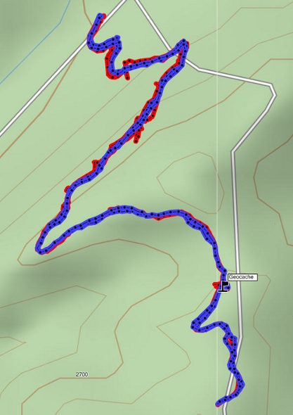
Multiple tracklogs were collected, comparing the Oregon 450 and the Garmin 60CSx. Tracking was set to collect points every five seconds while mountain biking. Steep terrain ridden in both directions, combined with frequent stops to record notes, resulted in good testing environments. In the images below, the Oregon 450 tracklog is in blue, the 60CSx is in red. I’ve compiled these four tracks in a single .gdb file, which you can download and open in MapSource or BaseCamp for closer examination.
In one test, shown below, the 60CSX wandered a bit more than the Oregon in a few spots, while the Oregon track separated more at one point on the uphill and downhill runs. This test was a draw.
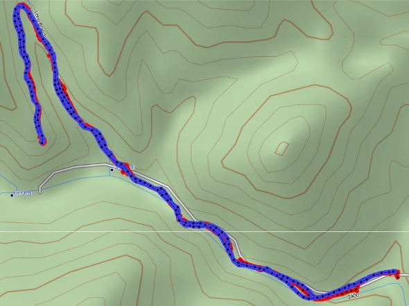
In the test below, the Oregon significantly outperformed the 60CSx. I’ve labeled a geocache at one point, because I moved around a fair bit there. Still there were two other points where the 60CSx wandered significantly. Each unit had a single instance of track separation on the uphill and downhill segments.
Battery life is rated by Garmin at 16 hours. In my testing it ranged from 10 hours, 27 minutes (backlight always on) to 16 hours, 51 minutes (backlight timeout set for two minutes, battery saver mode enabled). Battery life tests were conducted with the unit stationary, using Eneloop low discharge rechargeable batteries.
One other performance note — I’ve always been very impressed with how accurately my 60CSx reports overall elevation gain, and disappointed with the inaccurate numbers generated by my Oregon 400t. I was pleasantly surprised to see that the Oregon 450 is extremely close to my 60CSx in terms of reported elevation gain. I hope to do some more testing before I send the review unit back to Garmin, and will post a full report here.
UPDATE: Well, I set out on the trail to test this out and to my surprise, the 400t, 450 and 60CSx were all within 2% of each other. Perhaps Garmin fixed this on the Oregon x00 series in their most recent firmware update. Go figure!
Garmin Oregon 450 pros
- Tri-axial compass
- Barometric altimeter
- Great touch screen interface
- Ability to customize display and menus using profiles
- Excellent track management and routing tools
- Paperless geocaching support
- Availability of free maps
- Accepts Garmin custom raster maps
- Accepts Garmin Birds Eye imagery
- Improved visibility over previous Oregon series
Garmin Oregon 450 cons
- Somewhat poorer sunlight visibility than eTrex and GPSMAP color units
Recommendation and conclusion
Highly recommended. The Oregon 450 is a great workhorse, at a reasonable price. The interface is very user friendly and it has a lengthy feature set. It is an excellent choice for nearly any outdoor activity, including geocaching and hiking. This is the first Oregon I’m recommending for bikes too, due to the improved screen visibility, which makes it more appropriate for fixed-mount use.
More Garmin Oregon 450 reviews
- Consumer-authored Garmin Oregon 450 review
have been posted at Amazon
- More consumer reviews of the Oregon 450
have been posted at at REI.com
- A first impressions user review of the Oregon 450
- It’s Not About the Numbers reviews the Garmin 450 from a geocacher (and Blackberry user’s) perspective
I’ll be posting more hands on GPS reviews as they appear, but in the meantime, here are some…
Other Garmin Oregon 450 resources
- The Garmin Oregon 450 owners manual, in the language of your choice
- A Garmin Oregon message forum
- Use this chart to compare the Oregon 450 to other Garmin handheld GPS models
- There are links to more handheld GPS reviews in our buyers guide
- The Garmin Oregon wiki has an Oregon FAQ
- Trying to decide between the Oregon 450 and the Garmin 62 series? Maybe this will help
- Garmin Oregon training videos
- The official Garmin Oregon 450 web page
Compare prices on the Garmin Oregon 450 at these merchants:
- Check the current Garmin Oregon 450
price at Amazon
- Find the Garmin Oregon 450t at GPS City, one of our favorite low cost vendors
- Buy the Garmin Oregon 450
direct from Garmin
- Get a great deal on the Garmin Oregon 450 Handheld GPS
at J&R Computer
- Check out the deal on the Garmin Oregon 450 GPS
at REI.com, where satisfaction is guaranteed and members get 10% back on eligible purchases
- Get the Garmin Oregon 450
for an amazing price on eBay


Rich What a great help you have been with your reviews. I looking at the 450 but noticed its not waterproof or if it is I missed it. I do some kayaking and hiking and would like to get something for both. Could you recommend one for that. I don’t do overnight trips but might in the future. Most of the kayaking is on lakes or rivers looking for wild life to photo..Thank for your help?
The 450 is waterproof, but it won’t float, like the Garmin GPSMAP 78s. Of course the latter is usually more expensive too. Either way, you might want to consider BirdsEye imagery, which can be a big help on the water for checking out coves, islands, etc…
http://gpstracklog.com/2011/07/garmin-birdseye-satellite-imagery-2.html
Oregon 450 is not specifically designed for road use. But I still like to use it for that. It helps. The only problem I see on the screen that, before approaching a turn, there is no left or right arrow telling me to be prepared in advance. The actual arrow on the screen comes way later, which in same cases is too late for changing the lane especially in heavy city traffic. I had emailed Garmin about that way back, i was told the GPS did not have that future. I am assuming it is still case unless someone has figured something out? the montana version has that. but it comes with some other disadvantages as compared to oregon 450, that is why I am still keeping it. thanks
I’m trying to remember how it worked for me. Do you have the Automotive profile enabled? They’ve changed some settings and I no longer see one to show guidance text.
Just wondering about the batteries
what happens if i insert one full battery and one empty one does the device run and say 50% battery is remaining ?
Never tried it, but I doubt that the battery meter is that accurate.
ok, i am more wondering about how batteries work in general
for example will the device run from 1x full battery and 1x empty one
Haven’t tried it.
This is an old question, but you don’t want to mix full and depleted batteries.
Since they are hooked up in series, the voltage will look similar to a set at 50%, but the real trouble is current. The full battery will force current through the depleted one. This could result in one of two things:
Inability to power the device as the dead battery chokes the current.
Leaks from the dead battery due to the forced discharge. And alkali metals are not fun to get out of any electronics. Especially ones that cost a pretty penny, or have an SD card slot right under the batteries that you can ruin.
My Oregon 450 starting something wierd. The last couple of times it tracks my movements while it is off. I reset the trip odometer, etc., turn it off and leave it off overnight. When I get to the trailhead in the morning I turn the unit on and it will show how many miles I drove to the trailhead and even wierder it will give me and average speed of like 1134 mph! What is going on?
You need to set your Tracks>Track Log> Do Not Record if you do not want that to happen
I will try that. Thank you.
It’s probably just connecting the last track point when you had it on, with the first one once you turned it back on. I’m betting it didn’t record any locations in between.
I have recently encountered this issue as well. I will get to the trail head and reset the trip computer. It reads zero distance/speed/etc while there. Once on the trail it “remembers” the last point from the previous trip and instead of covering, say, 5 miles, it says I’ve done a few hundred.
It’s easy enough to edit the points once I’ve imported into BaseMap but it never did this before. I think a recent firmware upgrade may be the culprit.
That is exactly what it is doing! I had that happen many times so I figured out that all I had to do was turn off tracking when I was not using the 450.
Set your Tracks>Track Log> Do Not Record if you do not want that to happen. Then when you want to record your tracks turn it back on to record
@David – Are you clearing the tracklog at the trailhead?
At first I was not clearing the track log. Thinking that was the problem, I archived then cleared the current track. Then I reset the trip computer to zero. A few miles later it said I had covered a few hundred miles.
I still think the recent firmware upgrade is responsible for the new/different behavior.
David
I once relied on the 450 for accurate tracking of my hikes. But I think that its accuracy for both elevation and trip mileage has become significantly worse over the last couple of firmware upgrades. I’ve been on version 5.8 since it was released. Two weeks ago, I took a hike near Tahoe. I reset the trip odometer at the trail head and also calibrated the altimeter. When I reached my destination, the 450 showed 4.8 miles. I reset the trip information prior to the hike out, and the 450 recorded 4.2 miles back to the trail head. I was on the exact same trail in both directions, and I did not take any side jaunts. I set no waypoints. Back at the trail head, the elevation showed that I was 400 feet higher than when I began the day, even though I was at the same spot. There was no change in the weather. Back home, I loaded the track into Google Earth, and the distance was 4.1 miles one-way in both directions.
Just now, I turned on the 450 and reset all the trip data. I sat the 450 on my desk and left it for about 5 minutes. When I returned and looked a the trip data, it showed 1.16 miles on the odometer even though the 450 had not moved a single inch!.
While I love the features of the 450, I no longer trust it at all for giving any accurate readings. 🙁 I hope something is improved to fix this. Otherwise, I’ll just put the unit away and stop using it.
What are your track settings? For the most accurate results, I’d suggest setting it to record a track point every one second.
Just curious, when your track record setting is in “auto” mode, which method is it using time or distance & at what rate? I’ve always had it set in auto mode & noticed it wasn’t as accurate as the Legend H was. (You notice it when you track on the same path back.) It would be interesting to know what mode the Legend H uses. I know I will try the one second mode on the 450 now!
I’ve been using distance because after I purchased the 450, I tested distance versus time intervals. With time intervals, the memory filled up much more quickly. And it didn’t seem to make any difference in the accuracy. So my setting is to log every 0.01 mile, or about every 50 feet.
One thing I notice is that the GPS ACCURACY varies widely. I’ve seen it as low as 10 feet and as high as 150 feet. I’m not sure what conditions make the difference. But I’m guessing that if the accuracy is bad, like 100 feet, then when the unit makes a log entry, it could look like it’s moved 100 feet even if it hasn’t moved at all. So over a period of minutes or hours, these inaccurate loggings add up to a lot of distance error. So I tried a test of increasing the logging interval to 0.03 mile, or about 160 feet. But it didn’t help. I’ve considered rolling back to an earlier version of the firmware, but I haven’t had time for that.
Any suggestions would be greatly appreciated.
This is an update to my previous post on these issues.
I last used my Oregon 450 in early August and then put it aside until yesterday. Knowing the problems with the device “remembering” the last point I reset the Trip Computer to zero. Then I drove to the trailhead. Once there, I reset the Trip Computer to zero again. And I deleted the track. I walked around the parking lot for a minute — and reset the Trip Computer to zero again.
Hopped on the mountain bike and began riding. A few minutes later I stopped. The bike odometer read 0.22 miles. The Garmin 450 read 600+ miles. Suddenly it remembered my last position from over a month ago even though I had done three resets! The track, however, was okay.
Clearly this began with one of the more recent firmware upgrades because when it was new I never had this problem.
And the actual tracking yesterday was abysmal. Overlaying the track on terrain and/or Google images shows how awful it is with the track wandering all over the place.
At the end of the day, my bike odometer read 8.99 miles. The 450 read 9.5 miles.
So, how does one roll back to an earlier version of the firmware?
http://garmingpsmap.wikispaces.com/Versions#x-Can I force an upgrade or downgrade to a particular release?
I would back up my waypoints and profiles first.
I did some checking and learned that this problem with connecting the last point of the previous track with the first point of the current track was introduced in v5.80 that was released earlier this summer. The problem exists in v5.90 as well. Preliminary testing with v6.00 suggests it may still be present.
I noticed the problem after upgrading my 450 to v5.80 in early August.
I downgraded my Oregon 450 to v5.50 last night since many users have indicated that version is the last one to not have this problem. I’ll give it a test today.
-db-
I have been using the 450 since the beginning of the year. Love to use it for Geocaching. Also for making tracks while ATV riding & then downloading it to my TOPO! Nat Geo maps. I usually take along the good ol’ etrex Legend H ~ just for backup. When up at Horse Mt. Lookout in Idaho I noticed the posted elevation at 6887 ft. The Legend H was dead on but the 450 was showing about 300 ft. less. No trees blocking the “view” so I did the calibrate process ~ no change. I turned it off & back on & even took & changed the batteries. Still wrong. Thought maybe it was just off by exactly 300 ft but later it showed about 150 ft different. As I speak they are side by side the Legend H shows 2695 (correct) & the Oregon shows 2595. As one who loves to know the elevations, I am extremely dissapointed at this to say the least! Is this just a fluke or what? Any ideas?
The Legend H has no barometric altimeter, so your Oregon could be showing the effects of changes in barometric pressure, which wouldn’t affect the Legend H. Having said that, I have unfortunately found a great deal of variability between models and firmware versions when it comes to elevation accuracy. Is the firmware up to date? Also, here is one thing I’ve received from Garmin in the past on this subject…
“To ensure your unit is working properly. Make sure the unit has a calibrated barometer. You can do this by letting the unit sit at a fixed elevation for at least half an hour with a clear view of the sky to let the elevation trend to the correct number, or manually calibrating the barometer so that the elevation is correct. If weather is adversely affecting your altimeter ( pressure is changing due to weather instead of elevation changes ), you may disable it by setting the device to “fixed elevation” mode which will use GPS only for elevation data.”
Thanks Rich, as always for the valuable info! I don’t know how often they come out with updates but the firmware was updated at the beggining of the year. I tried the “let it sit” mode & also turned it to “fixed elevation” mode. In the end I just manually set it to match the Legend H. We’ll see how that does. I like all the extra things you can do with the Oregon, but also makes you realize how easily the basic ones can run themselves. Sometimes all these bells & whistles are a real pain! Wiki says using a barometric altimeter is supposed to be more accurate, but I’ve had just the opposite! Thanks again for your time!! ~ Sis Ban
The newest version is 5.80 released in June. You might want to give it a try.
Very, very new user of the Garmin 450….I have a few questions, but not sure how to post them, so you may see them. Mapsourse or Base camp better to use on the unit…?? While using a map, instead of the small blue arrow, would like to see the directional arrow, like my Nuvi 660 I use in the truck. When first discovered your website I have setup a couple of things in which I had no idea how to do…thks so much. When I bring up a Track I would like to follow, and there are many small green boxes along the trail, would like to elimate that so I can follow the trail better…anyways the questions could go on endlessly, but must not wear out my visit, and so very glad I found your site,
Thanks Again,
Bryan.
Basecamp.
I’m not sure what you’re looking for with the location marker. You can put it in automotive mode. Or put it in north up mode and it should point towards your destination.
What are the small green boxes? Geocaches? If so, I don’t think there is any way to hide geocaches loaded to the unit.
Also one more thing, my friend has the Dakota and I would like to transfer some of his maps….I’m showing Topo Ver 2 on my Oregon 450…and he has Ver 4…will the 2 marry up. I have a memory stick, and would like to keep all my geocaches on the stick to keep separated from other things, is this possible.
Thanks,
Bryan
If his map is on a DVD, yes, you can transfer it to your unit.
You can place geocaches on a microSD card. Create a Garmin/GPX directory and put them there.
@Sis Ban – I’m not sure what their algorithm is. Do both units have the same settings?
Al Gore who? ~ Just kiddin’ ~ had to look that one up on Wiki to know what it meant, but anyways yes I’ve always just had the tracking on auto, on both units, whatever method it uses time or distance that’s a good question………
@George – Yes, that setting will eat up the memory!
The GPS constellation is not geosynchronous, so there are good days and bad days in terms of how many satellites are available for your receiver. That and possibly terrain differences are the most likely explanations.
Is there a 12 volt car charger that will work on the Oregon 450-450T? I would like to plug it in on my ATV
Thanks
Randy
I know that my old car cell phone charger fits my Oregon 450 and powers it, although my new one doesn’t. I also know that there are some car chargers out there where you can plug a USB cable into it, if you were to use the cable you use for your 450?
Thanks Nick for the reply. I did actually see they do make them. I guess my concern is that, if i do use a 12volt charger that plugs into my 450, that the charger won’t burn it up my unit or try to charge the batteries that are in it. So the power cord must act like external power. (Oregon 450).
Thanks
Randy
The Garmin cable will work fine. Others may cause problems, the most likely being sending it into mass storage mode.
Randy, I have rechargeable batteries in my 450, and regardless of whether I use the USB cable I attach to my laptop or the one which will connect in the car, it doesn’t charge the batteries, but rather acts as an external power source. I’m not sure if it could burn your unit being plugged into the ATV, but it hasn’t with mine if I plug the car charger into my sedan. Haven’t used it with an ATV, although I think it could be quite useful with an ATV. When you plug it in it’ll ask if you want to go into mass storage mode, so you’ll need to say “no” and then it’ll run like it normally does except using an external power source.
I know Rich earlier said mounting GPS units with touch screens to things like bicycles have more Sun glare than the joystick/buttons units, but then they’re much faster when typing letters in (and in my opinion much better at scrolling north/south/east/west).
And glare won’t be a big issue if it has external power. Should be plenty bright then!
Thanks everyone for all the info. I’m going to try give it a try. When i do use the light on bright, in which I do most of the time, it sure does drain the batteries down fast. So the power cord should sure will help with problem. I will report back after my first use.
Thanks again,
Randy
Not sure if you guys over the pond are getting the same offer but over here in the UK I’ve seen a few offers popping up for an extra £50 off the Oregon 450 bundle e.g. http://www.aboveandbeyond.co.uk/.garmin-oregon-450-handheld-gps-with-1-50k-gb-discoverer-full-uk-map_sku2060.htm. If your thinking about buying the oregon could be an idea to have a shop around your American retailers to see if they are running something similar. Great to see them becoming more accessible price-wise. Damn shame I already have one though :-). Would defo recommend though because it has made geocaching with the kids really fun. I think i get a bigger buzz out of it than they do 🙂
I recently purchased a Garmin Oregon 450T and it works great…. until I change out the Lithium batteries. After changing the batteries the map pointer stops working correctly and will not point at waypoints that I have created even though I am pointed right at them. I have tried reseting the battery type in settings and reboot the GPS but this doesn’t correct the issue. When I place the original batteries back in the GPS the map pointer works normally again. This behavior holds true whether I’m in Track Up or Automobile mode within the map settings. Please let me know if you have any ideas on why this issue is occurring because other then this issue I have enjoyed the Garmin Oregon 450T.
You need to calibrate the compass each time you change batteries. Hold down the center of the compass to go into calibration mode.
Just wondering ….I saw the automobile pointer screen shot…Just wondering where in my settings I can change to this option….it likely would work nice while travelling in my side x side, and I could see where I,m going.
Just change to the automotive profile, but you will need to have routable maps installed to get that effect.
Planning of getting the Oregon 450 soon, and wanted to know if I wold loose some or
any information when i changed batteries while on a hiking trip? This is my first GPS and
hope I am making a good choice.
Thanks
Ronnie
No. It’s a good unit. Since this is your first GPS, I suggest reading thru our handheld GPS FAQs, especially the handheld GPS 101 series…
http://gpstracklog.com/category/handheld-sport-gps/handheld-gps-101
Planning to buy the Oregon450 soon which will be my first GPS. Can anyone tell
me if while on a hiking trip can I replace the batteries with out loosing any or all
of my data that i entered while on hike.
Thanks
Ronnie
Ronnie, when I go on long hiking trips, I’ll replace the batteries on my Garmin Oregon 450 out in the wilderness and have never lost my data/waypoints entered on the trip from that. (On one rare occasion, however, I lost my waypoints by going under settings and accidentally hitting “RESET” for waypoints rather than tracks, but luckily I backup all my waypoints on my computer every once in a while). If you do change your batteries, from what I understand any unit you have you’re supposed to recalibrate your compass, but it’s no big deal, and if you’re moving the compass issue won’t matter anyway, just when you’re standing still.
As far as battery life, I’ve noticed my Oregon 450’s battery life is 16 hours if the screen is off but unit still on, and 10 hours if I’m constantly using it (the bigger screen and touch screen I assume make it an energy guzzler compared to the eTrex, however for other reasons I like the 450 a lot more than the Garmin eTrex Vista HCx which lasts 25 hours, so that’s why I took that unit back to Costco and went with the Oregon 450 instead). Another thing to consider, if you use rechargeable batteries, normal ones don’t last very long before they’re out of juice, and the manual recommends using at least 2600 mAh AA batteries (I use 2500 mAh rechargeable AA’s from Radio Shack, and they seem to last for quite some time).
Thanks a bunch! looks like it will be the 450 without a doupt.
Ronnie
Ronnie, I see you posted again. Did you see my earlier reply?… http://gpstracklog.com/2010/04/garmin-oregon-450-review.html/comment-page-9#comment-214614
Yes and thanks very much!!! I have a couple more questions and it is on the
Garmin550. Sorry for asking so many questions Rich. But it the screen just
as good on the 550 as the 450? And can u actually use the camera for just
taking pics. of the family and downloading them to Picasa. We do Geo cach.
some and plan to get into the activity more as the weather cools here down
south. I guess the biggest question is the Camera the only difference between
the 550 and 450. Thanks so much Rich for all the valuable info. and for
the Web site you have.
Ronnie
@Ronnie – Yes, the camera should be the only difference; they updated the screen on the 550 a couple of years ago. The camera isn’t that great for family pics, but it’s nice to have one in your GPS when you’re in the middle of nowhere.
Thanks so much for helping me make the best decision Rich.
Ronnie
You’re welcome!
Ive been doing a lot of review reading lately and several of the U-Tube comparisons seem to
point to the GPSMAP 62st has a more sensitive antenna. IF paying the big $s is there a gain
in sensitivity. I understand about the touch screen versus the button type when it comes to
screen readability, but what else are the benefits of paying the higher price. Hope to go to
Bass Pro soon to put my hands on them. Thanks Again
Ronnie
This is a little dated but… http://gpstracklog.com/2010/07/garmin-gpsmap-62s-or-oregon-450.html
I don’t know that either has a leg up on reception, but I prefer the 62s myself.
Well Ive read the 101 link and thanks for the info. My primary use is Geocaching right now and
I have a question. When I pick the cach and select go, can i select something to see the cooridanates and when i get close maybe let me know how many feet im supposed to be to the
corrrect location? Guess im used to the Neogeo on my phone and it does a great job for me.
Any info would be appreciated Rich.
Thanks Again
Ronmat
I’d suggest one of the following to see how close you are to the cache coordiantes:
Go to Profile Change and make sure you have Geocaching selected. If the geocaching dashboard doesn’t show on the map screen, go to Setup > Map > Data Fields > Dashboard and select one of the Geocaching options.
Or, on the compass screen, tap a data field and select Distance to Destination.
This FAQ may also help… http://garminoregon.wikispaces.com/Geocaching
Man Thanks a bunch, just did it and its just what i wanted. Can i go into any profile and
and do this?
Thanks Again
Absolutely! Glad to help!
Just got the Oregon 450 and after one day I’m frustrated! I have managed to lose the MAP icon while trying vainly to download Basecamp and the NE topo maps. How can I do all of the above? I am not a techie and this thing is beyond me. The “manual” is less than user friendly to a 60+ old lady !
The map icon is gone from the 450?
Yes, it had been there, but I evidently did something while I was trying to download base camp. 🙁
It’s nowhere to be found ! I still can’t load any maps.
Basecamp goes on your PC not the 450 GPS. You should be able to do a factory reset and get it back to the original state
What is a factory reset and how do I go about getting it? OK, I got base camp finally on the computer, but I had to download it to iTunes. For some reason, even though I have the communicator downloaded also, my device doesn’t show up on the iTunes tool bar. This is getting way too complicated for me. Maybe I need to go back to an old-fashioned map and compass.
@Peg, this should be easier. Go to Setup > Main Menu and then scroll right. You should see Map as a greyed out icon. Tap it and hit + to get it back on the main menu.
To move it to the first screen, tap it and then tap an item on the first screen and they will switch places.
you can also see http://www.youtube.com/watch?v=I5PY88KIVcE
Thanks Marko.
@Peg, Handheld GPS have a bit of a learning curve, but I’d encourage you to stick with it. This may help…
http://gpstracklog.com/handheld-gps-faqs
OK, I finally got the map icon back on my Oregon 450. Thanks for that. Now the trouble is Basecamp. It is supposedly down;loaded to my laptop. It automatically was sdaved in iTunes. I can’t seem to open it up. I tried to download it elsewhere, but it wouldn’t go any other place. Suggestions? This is ridiculous. Been hiking a lot, but without my new toy…it’s been a couple of weeks struggling with this thing. Learning curve, I guess so!
Are you Mac or Windows?
Mac. New mac pro laptop. I downloaded the app for a mac.
It should be in your Apps folder. If not, you probably downloaded it but it never installed. In that case, it should be in your Downloads folder and ready to install.
It’s there in the downloads, but when I click it, it says no application in which to open it.
It’s there in the downloads, but when I click it, it says no application in which to open it. What now? I know I’m being a real pain here….beginning to think I’ve thrown away $300.
@Peg, I would re-download it again from http://www8.garmin.com/support/download_details.jsp?id=4449 and then try to open the new file.
Alternatively, you can download it from the App Store, but it may be an older version that needs to be updated.
Bingo! You’re a whiz! Now, to learn how to use the thing! I doubt you’re quit of me yet, but I promise not to be TOO pesty 🙂
Glad to help! As far as learning it goes, check this out… http://www8.garmin.com/learningcenter/training/basecamp/#Mac
I have a question about adding maps. What is the best option for adding maps? Micro SD or using the downloadable software. My thoughts are that I would get a 32 gb micor card and download all the maps to it, us topo maps, us city navigator and Im goint to Europe this summer. I just want the maps on my gps all the time and I want to be able to update them. Also is it better to buy the garmin topo maps or is there a place to get quality free downloads. I have considered just buying each indiviual map sd card but I want to run multiple maps at once. Any thoughts on mapping ideas?
I would put what you can on internal memory and then add a microSD card as needed.
I’m not sure a 32GB card will work. See H4 here… https://garminoregon.wikispaces.com/Hardware
There are some good free maps available at http://gpsfiledepot.com
If you’re buying Garmin topos, I prefer DVDs. That way if you ever replace your device, you can still use them. I believe that downloads are locked to a single device.
Hope this helps.
I am beginning to feel really hopeless. I have gone through just about every tutorial I can find for the Oregon450. I have managed to get a lot of “trash” stuck on my base camp, yet I still haven’t figured out a way to get the maps that I really need. I have used the freebie sites, hence the junk. What I am looking for are trail maps for the White Mountains in NH and Maine, and the Greens in Vt. What are the sources?
Questions: How and where can I get those (not just topos, but real trail maps)? How to I get rid of the stuff in Basecamp that I don’t want? Despite tutorials, I still can’t transfer data to the gps unit…what might I be doing wrong?
I’m ready to throw this thing out the window! Did I waste the money?
Peg,
In your apps, you should have Garmin Map Manager. Right click on any map to delete it.
Trails are hard. There often aren’t good trail maps available for many areas. You might want to try this one…
http://gpsfiledepot.com/maps/view/53
You can also go through the maps for those states at http://gpsfiledepot.com and try some of them out, but it’s going to be hit or miss.
This is how I generally handle getting trail maps…
http://gpstracklog.com/2012/02/handheld-gps-201-using-online-tracks-for-trails.html It is by far the best solution, but you have to look every time you go out.
What are you having trouble transferring – maps? waypoints?
Hang in there – we’re here to help.
Rich, I can get a 550T for $20 more than the 450. Any reason not to get the 550T? I’m guessing I can get the maps, etc that you mentioned and put them on the 550T unit.
I don’t have the 550T, just the 450, but I know the Garmin website allows you to compare their products side by side. https://buy.garmin.com/shop/compare.do?cID=143&compareProduct=26876&compareProduct=63350&compareProduct=63349&ra=true
It looks like the 550T and 450 are the exact same dimensions and weight, if you care about how much room and weight you take up while hiking. The only difference appears to be the 550T also comes with pre-loaded shaded relief topo maps of the entire United States, a 3.2 megapixel auto-focus 4x digital (not optical) zoom camera, and 2 AA NiMH batteries.
No, I see no reason not to. You’ll get the camera for just $20 more.
Rich do you have any updates from April 13, 2010 on the Garmin Oregon 450? Is there a newer similiar model you are keener on?
H
I prefer the 62s or even the eTrex 20 or 30 myself. How will you be using it? Biking, hiking, geocaching?
Quick question Rich. I want to go to a certain area and hide a Christmas Present, then
give the GPS as a gift, and give the person the coordinates of where the gift is at. Could you give a little info. on doing this I have a 450 and 650 garmin.
thanks
Ronnie
Go to the location and, on the Oregon 450, choose Mark Waypoint. For more accuracy do this from the Waypoint Averaging menu. You may also want to calibrate the compass before giving them the GPS.
OK I got the way point marked, and i found the page that i select go to way point but i dont see any coordinates? what can i do now to put the coordinates on that map screen which will let her know the direction and how many feet, coord. etc.
Thanks a bunch Rich
Ronnie
Hopefully after Christmas I can get a lot of hands on these GPS and maybe i want have to bug yo so much
The easiest thing to do is use the compass screen. Tap the data fields if one doesn’t already show Distance to Destination. No need to show coordinates.
OK, I give up. I have had my Oregon 450 for about a month and truly regret buying it. Is there a website where one can sell these things ? Is there a maker for hardly used GPS’s ?
I meant, is there a MARKET not maker for used GPS’s.
Can you return it where you bought it? Otherwise there is eBay and Craigslist.
Have you been through our handheld GPS 101 series?… http://gpstracklog.com/category/handheld-sport-gps/handheld-gps-101
If you still have your GPS, is there a local hiking club you can join in which some member has probably navigated the rough waters that now present such trouble? This could be a “two birds with one stone” opportunity.
If you’re looking for local hiking groups to show you around, there’s http://www.meetup.com You can search “hiking” (or this time of year “snowshoeing”, if you have shoes). You can also tell it to search within 25 miles or so within a certain zip code.
About your question on why waypoints are moving around, I don’t know too much about GPS but I do know every once in a while when Garmin does software upgrades for the unit, weird things happen. For example, right now I’ll tell a certain track I had named earlier to be hidden from my map. However, once I turn the unit off it keeps on coming back, so I have to keep on changing the options from “Show on map” to “Hide on Map”. I suspect that may go away when there’s the next software update, because that’s how another minor issue was resolved earlier and when I looked at what software updates they had made Garmin said correcting that error was one of them!
Also, although I like a GPS a lot better than a map and compass, personally I think it may be worthwhile to get a map/compass as a backup just in case you ever have software issues when you’re out in the wilderness!
I found you can print free topo maps from http://caltopo.com Although these topographic maps don’t print on your printer as well as subscription maps you pay $40 per year (and certain Internet browsers have print sizing issues), at least it’s free, and you can fit the map inside one of those gallon zip lock bags to protect it. After that, roll it up and you can use it with a protractor/sighting mirror compass.
You can change this map from flat to shaded relief, and shift between the various coordinate systems once you click that printer icon next to the “Go” button.
rich, I’m guessing you’ve answered this before but I haven’t seen it. My waypoints have the distsressing tendency to move after I’ve set them. In a recent shuttle, I parked at point A and entered a waypoint and then drove to point B where i reset the tracks and data avgs to zero and started hiking toward point A through the desert. When I checked it a bit later, Point A had taken up with Point B. What’s going on here?
Unless you didn’t hit save, or you happened to move the pin on the map, I’ve no idea.
I’m planning to get a Garmin 450.
1. I’m a Hiker and pretty novice when it comes to GPS, is Garmin Oregon 450 a good starter GPS?
2. I see them for $199 refurbished on Garmin eBay store, is it safe buying for that price?
3. With all Electronics, will this GPS gets outdated in next 1 yr? or am I good for next 2-3 years.
Thanks.
I got one in December and have given up trying to learn how to use it! I am 61 and must be the “old dog”. because I plan to sell it !
Hi Peg, a\can you please send me details to my email.
mamamia69atgmaildotcom
There are new models coming out in March… http://gpstracklog.com/2013/01/garmin-oregon-600-series-gets-glonass-customizable-buttons-8mp-camera-battery-options-multi-touch-display.html.
Whether its a good unit or not depends on your use… hiking, biking, geocaching?
hiking and backpacking.
Backpacking suggests battery life and weight would be an issue. You may want to look at the Garmin eTrex 20 or 30.
I have an Edge705. I can copy a gpx track from my computer into a GPX folder in my 705 and make my 705 navigate that track. Can I do the same thing on the Oregon 450?
Yes.
Hello. I researched in this topic and website, but i could not find out which chipset is used on Oregon 450. It’s important information for me because I intend to use an application that requires chipset SiRFStar (II, III or IV).
I have an Etrex 30 (STMicroelectronics chipset STA8088EXG) and a Oregon 450 (chipset??). I hope not to have to disassemble it to find out 🙂 Thanks
No curent Garmin handhelds use SiRF products. The Oregon uses the ST Micro Cartesio: http://www.gpspassion.com/fr/articles.asp?id=259
Hey Rich, Ive learned a little more and have a couple of new questions. I have created
bookmarks on Geocaching.com and sent them to my 450 and 650. Just today I gained
the ability to create a PQ. OK now I have aprox. 50 single bookmarks on the GPS and I
have created a PQ of a couple hundred which will be sent tomorrow Sat. to my by email.
My question is, there are going to be some duplicates in bookmarks and th PQ, will the
PQ be a seperate file from the bookmarks that i already have? Or will the duplicates only
show in one or the other bookmark or PQ. I hope it will be duplicated just so i can delete
the bookmarks if i want to and keep the PQ in the GPS. Question 2 can i wireless share
the entire PQ to another GPS or will have to share each cach one at a time.
Thanks for all the Help in the past
Ronnie Matthews
Ronnie,
Honestly, you’ll probably get a better answer asking this at http://forums.groundspeak.com/GC/index.php?showforum=11
Rick, sometimes I click off my GPS at the end of a hike but get home and discover that the GPS really didn’t shut off and has added the 75 miles home to the end of the hike. I’ve tried setting up new files, cutting and pasting to retrieve the electronic breadcrumbs of just the walking hike, not the driving hike, but Basecamp seems to like all or nothing. I can’t seem to selectively move or delete highlighted segments??? Is there a way to do this? Thanks for all the help you give.
You should be able to save the track at the end of the hike to eliminate this issue. The track files can be edited in BaseCamp, as described here under “Edit Track Points on Map”: http://garminbasecamp.wikispaces.com/Tracks
Also, the free version of TopoFusion has a great track importer that totally eliminates this issue.
Hi, Rich:
I read your review and ordered one Oregon 450. Now I want to load New Mexico Topo map on my GPS since I have a trip to NM this Saturday.
I download the map to my computer; I download BaseCamp also. I put MicroSD to the card reader. I can see the SD on the left side when I open BaseCamp. And then I right click the folder named “user data” under SD. I click “Install maps on memory card”. No map list shown. MapInstall window shows ” No unlocked maps were found for this device”. I tried 2 computers. They did the same way.
Now I don’t know what to do. I ordered the GPS from Amazon and almost one month. I’m thinking about to return it.
Can you help me and give me some hints? thanks.
The problem I have is that BaseCamp can not find the Topo map I downloaded. So I can not load the map on my GPS.
Have you followed the tutorials at http://gpsfiledepot.com?
Hi, Rich:
Thanks for your reply.
Yes, I did follow the tutorials. My friend also helps me to try. I just can not find the map and open it using BaseCamp. I tried MapSouce also. Still can not find the map.
I just tried my Vista computer. Looks like it works. Both Window 7 and Window 8 don’t work.
I’ll try more and let you know. Thanks.
Are you on Windows or Mac?
Windows: different Window versions.
Glad you got it figured out. Not sure what was up with that. You may want to post about it on the http://gpsfiledepot.com forums.
Been away from caching for a spell and forget a few things.
a. would like to generate a file where I can keep all my geocaches
b.being a premium member for a long time would like to open my PQ in my new generated file.
c.download all the generated PQ caches all at once, my GPS is a Oregon 450.
Are those questions?
If I install a 4GB micro card do you think it will handle the storage capacity of the download North American City Maps and a few regional topos? I read another review where the user had the maps card loaded and the tried to install additional maps and it locked up the card. Have you heard of this problem?
Hi, I am curious, I have a 2010 oregon 450. have they changed or improved over the last 3 years?
Yes…
http://gpstracklog.com/2013/01/garmin-oregon-600-series-gets-glonass-customizable-buttons-8mp-camera-battery-options-multi-touch-display.html
http://gpstracklog.com/2013/05/garmin-oregon-650-review.html
I hope to have my own review of the 600 posted late this month. Like most new units, it is not without bugs.
First, thanks for all your posts, I’ve learned a lot.
My question, I store .gpx files on a SD card, if I store them in a /garmin/gpx folder are they accessible without connecting to my computer and moving them to the internal memory?
Thanks in advance
Marty
It will use files (e.g., track, waypoint, geocache, etc.) files from the card, if that’s what you’re asking.
The compass setting seems to be locked on finding one location, I cannot seem to get it to change to a different waypoint.
Where To > Stop Navigation.
Hello I have had my Oregon 450 for over a year now. When I am geocaching and going to a cache, the direction line moves all over the place – left, right, middle of the screen. As I get close to the cache it settles down. My zoom is 20 feet. I know that is close but don’t like to zoom out and in all the time. Is this normal with these units? My Nuvi 660 does not do this. It is rock solid.
My second question: Lately the 450 has been very inaccurate – as much as 35 to 100 feet off out in the open. Again, my Nuvi 660 is right at ground zero. I had not been re-calibrating the compass when changing batteries and did not have any problems with accuracy. I have started re-calibrating,but it does not help. Any ideas as to what is going on? I have not done any firmware updates. But I would not think that would have anything to do with the accuracy changing.
Thanks for any input.
Jim
You could try switching off the electronic compass (under Setup > Heading > Compass) and see if that helps.
A hard reset may help (backup first) but I would also update the firmware.
My Oregon 450 draws UNWANTED straight lines between waypoints where I have not run the tracklog. They show up on BaseCamp and spoil the complex trail map I am trying to create. How can I stop it from doing this? Even more important is how can I erase these (non-track) lines from the BaseCamp map. The eraser tool doesn’t seem to touch them.
I suggest saving the track at the end of your last trip. Next time you start, wait for satellite lock and then clear the tracklog. That should do it. The free version of TopoFusion offers a great track importer that can clean up this mess as you download tracks.
For existing files, you need to go back and find the origin point of those straight lines and then erase the track points there.
Rich, a friend of mine is under the impression that the Oregon 450 will show other Oregon’s in the area? can you please clarify?
Thanks
Richard
It will not, although if they are within a few feet of each other, you can wirelessly share waypoints routes, tracks and/or geoocaches.
Hi Rich,
Thanks for the great reviews! I’m considering buying the Oregon 450, but am questioning if this makes sense given that it is almost 4 years old. I understanding the Oregon 600/650 came out earlier this year, but at $400+ it is over my budget. I’m hoping to stay close to $200. I’m looking something primarily for hiking, geocaching, and occasional backpacking. This would be my first handheld GPS; I have little to no experience with them. The touch screen *seems* like it would be nice compared to using buttons, but I haven’t been able to find any local stores with the 450 to actually try it and compare with say an e-Trex 30! What would you recommend, and what has your experience been with touch vs. non-touch? Thanks!
I should also add that I would like to create some topographic/shaded relief trail maps as well. I understand that GPS topographic maps can be created with the US Topo GeoPDFs in conjunction with the TerraGo toolbar. However, this requires an NMEA 0183 compatible GPS. The e-Trex 30 lacks this compatibility. I’m not even sure if this is the best method either. But after reader your bio, I understand that you are an expert in this area! Do you have any GPS mapping software recommendations along with a particular GPS to use as described above? I would buy your book but it appears to be 8 years old. Thanks!
The easiest way to put USGS topos on the device is to pick up a Garmin BirdsEye topo subscription ($30/yr). Otherwise you can use the Garmin custom maps process to calibrate and load GeoPDFs.
Rich,
Thanks for the feedback! Perhaps I am not understanding correctly, but I’m actually looking to map out tracks onto a printable map. I want to export the tracklog from the GPS onto a map exactly like the tracks you show on the shaded relief maps in this review. How do you do that? Which software/maps do you use? And do you need an NMEA 0183 compatible GPS to do so?
Thanks!
There are many ways to do that, and no, you don’t need a NMMEA compatible unit. My favorite for printing has been National Geographic TOPO but it has been discontinued. I would suggest experimenting with Garmin BaseCamp but there should be plenty of other options out there. Here’s some suggested reading if you haven’t come across these posts:
http://gpstracklog.com/handheld-gps-faqs
http://gpstracklog.com/2012/01/handheld-gps-201-mapping-software.html
I am not a fan of the screen on the 450. If you can hold out till Black Friday you *might* be able to pick up a 62s for $200.
Rich, bought my Oregon 450 about 4 yrs ago at your recommend and extremely happy with it. But gravity got the best of it today and the screen got smashed so I can’t read it. Basecamp, however,had no problem downloading all the data from it. Tried to report it to Garmin to see if economical to fix but I couldn’t get their system to accept my query as they couldn’t connect to it, they said.
Would you have any guess on this as to repair possibility, cost? I see them advertised now for $190 or so therefore unless repairs are under $100, not worth the trouble of fixing to me. Would you just go get a new on in that case or is there something a lot better for hiking?
Thanks for your help on this Rich. You are far more reliable and easy to deal with than the company.
It’s $99… http://www8.garmin.com/support/outofwarranty.html
Okay, I bought a refurbished 450 for $169, free shipping which has software 6.20 in it. The updater thinks it ought to have the updates. I’ve looked at what they offer and I don’t need, it, I think. I alway update my computer but I never updated my previous 450 and it performed good enough for my hiking requirements(although it took 3 or 4 minutes to find the right starting altitude). So, my naive question is, under these conditions would you bother to update. I’m also not updating basecamp as I’m concerned about all their warnings and it works good enough for me. thoughts? Thanks.
Probably no need to update then.
Topofusion directed me to upload a lovely .kmz file of a topo map covered with tracks to a Custom Maps Folder in my Oregon 450. When I hook the Garmin to the computer, it says the file is there. However, I have not found a way to access this file on the Garmin. Was all that hiking for naught? How do I get the Oregon to process this file and present the map?
Do you see it under Setup > Map > Map Information?
Yes it was there. Said it was Disabled. I Enabled it but still don’t see a way to get it displayed on the screen. What next?
Scroll the map to that area and see if you see the custom map. If not, try disabling other maps and see if it shows. If not, check this list of requirements.
Being a user of Garmin Oregon 450 for quite a time now, I must say that I am still impressed. Impressed mainly by how awfully buggy its software is. And what about these annoying requests for me to rotate it around its axis? I don’t know how to express my extreme disgrace à propos de tout ça !
Almost everything you can find as an alternative to this piece of junk will prove to be better. I would exchange it for a good compass if I could find someone stupid enough for such a barter.
I’ve had my Oregon 450 for over 2 years now & I’m very happy with it. This is a great site to ask for help if you need it!
Creative name Klitorina. I’ll trade you my compass for your Oregon 450!
I would love to have another 450, my 9 yr. old really enjoys it too.