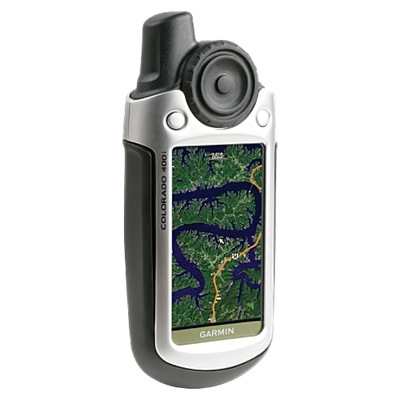
I bet I’ve answered this dozens of times in our comments, so this is a long overdue post. Not that many years ago, most auto GPS units didn’t speak street names; you’d hear “turn right in 1/4 mile.” Nowadays, most models have text-to-speech capabilities and will say something like, “turn right on Oak Street in 1/4 mile.” read more
What to do about GPS reception problems
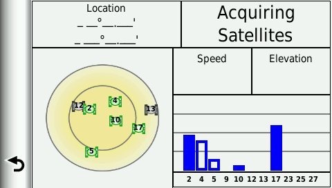 Is your GPS not locking onto satellites? There’s usually a simple solution that works for both auto and handheld GPS units, but first, let’s look at why this is happening.
Archived trip logs on Garmin nuvis
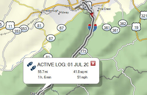 Most newer nuvis can record your trip log (AKA tracklog, and yes, that’s where this site’s name comes from). But did you know you can go back and view 200,000 points worth of data? Well, it’s all there, under Garmin/GPX/Archive.
GPS reception myths and misconceptions
An interview with TeleNav’s Bob Rennard
 Most of us have had times when GPS reception was challenging, and it’s easy to make a leap in logic and blame it on current environmental conditions. Today, I’m happy to say that Bob Rennard, TeleNav co-founder and Chief Technical Officer, has agreed to tackle these issues head on in an interview with GPS Tracklog. So lets see if we can clear up some GPS reception myths and misconceptions…
Bob, can you tell our readers a bit about your background and what role you played in the development of GPS?
Dual use GPS for road and trail
UPDATE: The Magellan eXplorist 710, introduced in the fall of 2010, is another dual-use unit worthy of consideration.
UPDATE 2: Garmin has a new dual use entry with their Garmin Montana series.
I want a GPS that does it all; this has got to be one of the most frequent requests I hear.
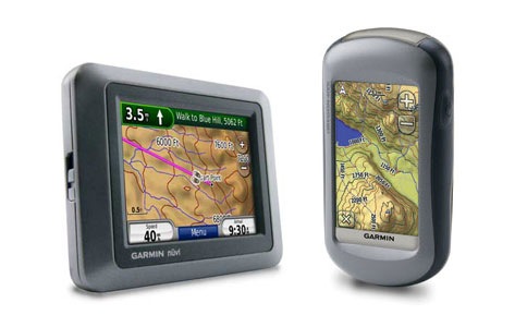
Several companies have tried to create GPS receivers that will work well on the road or in your hand — for backcountry use, geocaching or what have you. The latest example is the Garmin nuvi 500 series, pictured above at left.
Tech talk – raster vs. vector, or why has it taken so long to get aerial photos and USGS topos?
What makes aerial photos and USGS topo maps so different that we’ve been waiting years to get them on our GPS screens? A few companies have started offering these images in the past year. But so far, Garmin, the king of GPS receivers, has not had this capability (with the exception of limited aerial imagery of ports on some marine units).
To address this, we first need to define two types of imagery and the problems they can cause. I’ll close with what’s coming from Garmin and Magellan in this regard.
Switching between highway and topo maps on Garmin handhelds
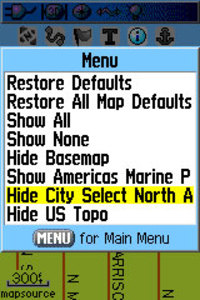
Oftentimes, handheld users will load both highway and topo maps to their unit. Garmin handhelds will show the highway maps by default. The highway map (City Navigator or City Select) for an area must be turned off before you can see the topo map. This is especially problematic when you have a lot of maps loaded and you don’t know the name of the map for your current location.
In the past, I’ve laboriously scrolled through long lists of highway maps, deselecting each one until contour lines appeared on the map. But there is a simple solution. The instructions below are for the Garmin 60CSx, but I’m hoping this works for the eTrex series too. Perhaps someone can verify that and comment below.
From the map screen, press Menu, then Setup Map, and scroll over to Map Setup – Information. You’ll see your list of loaded maps with a check mark next to each one. But rather than de-selecting them one by one, press Menu again and you’ll see two choices – Hide City Select (or Navigator) and Hide US Topo, as shown in the image. Pretty cool, huh?
Thanks to Hogrod on Groundspeak for this tip.
What’s a GPS mouse?
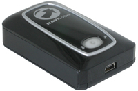
A post about a GPS mouse on Slippery Brick caught my attention this morning. To quote:
This is an interesting combination of peripherals if nothing else. A company called Navilock out of Germany who specializes in GPS products has produced a Bluetooth enabled mouse that also acts as a GPS receiver. This is convenient in that if you are looking for a powerful GPS antenna and you are going to be using a mouse anyway, you can now just get them both in one device adding less clutter to your workspace.
Sorry guys, but you’re wrong. This thing ain’t no mouse. The term "GPS mouse" refers to the shape and size of the device, and has come to mean any wired or wireless GPS receiver that doesn’t come with any sort of interface. It merely outputs position data to a laptop, cell phone, etc.
Top posts of 2006: The year in review
While blogs like this have a lot going for them, one of their weaknesses is that old posts quickly get lost, so I like to do an annual review, and highlight more recent popular posts in the sidebar. With that introduction, here are the top 20 most popular posts from 2006, and a few others to boot:
- SiRFstar III – Why it’s a big deal – The chipset of choice. It is so cool to get a signal lock indoors!
- Custom POI’s – 6 million POIs not enough for you? Maybe the NAVTEQ or Teleatlas database doesn’t have your favorite fast food chain. Check out these resources. Someone else may have already done the hard work for you.
- Handheld GPS recommendations – ‘Nuff said.
- Consumer Reports rates GPS receivers – People value these independent reviews.
- Garmin City Select vs. City Navigator – This has got to be one of the most common questions out there for owners of Garmin handhelds wishing to use them for auto navigation.
- Automotive GPS recommendations – ‘Nuff said.
- Hacking eXplorist 100, 200 and 300 GPS receivers – Now you can get a PC interface cable for these Magellan units.
- Why have a barometric altimeter? – The joys of knowing your elevation and elevation gain.
- How to create custom POIs for your Garmin GPS – If you looked at item number two, but couldn’t find what you were looking for, here is a DIY resource.
- Why have an electronic compass? – Didn’t REM do some songs about this (Standing Still, Stand)? How to tell which way you’re facing while standing still.
- GPS rebates and deals – Everybody loves a deal.
- Does the nuvi have a weak feature set and interface? – Maybe, but much depends on what you are looking for. The nuvi is still the best at lots of things.
- Garmin nuvi compared to Mobile XT – More on that last one.
- Garmin to focus more on pre-programmed SD cards? – Can you say "planned obsolescence?" How about "legacy product?"
- Free maps of Japan for Garmin GPS receivers – Everybody loves getting something for free.
- GPS for your car: Factory-installed or aftermarket unit? – Puh-lease. This is a no brainer!
- Can my GPS be used to track me? – The short answer? Not unless it has a transmitter.
- Pros and cons of PDA-based GPS receivers – They do it all, but they sure are fragile. Now where did I put my stylus?
- Convert National Geographic TOPO (.tpo) files – GPS lovers that use TOPO should send Robert Lipe a thank you!
- DesktopEarth – Eye candy for your desktop.
50 GPS message boards
Call them message boards, discussion groups, online forums, or some other combination of those terms — Connecting with other folks on the web, who are using your particular brand of GPS can be one of the quickest ways to get an answer on anything from basic noobie queries to perplexing technical questions. Especially helpful are groups that focus on particular brands and models of GPS.
A few caveats before the list of message boards…I’ve tried to screen out those groups dominated by spam. Also, some of these groups overlap, and they vary greatly in posting volume. Speaking of which, I have one tip for the many Yahoo groups below — you may want to choose to view messages on the web only, rather than by email, lest your inbox quickly become clogged. Finally, be sure to drill up and down through these websites. There were just too many forums to list them all, and there are other great message boards out there.

