Sunday, March 18, 2012

Garmin BlueChart Mobile app for iOS released

Garmin Bluechart Mobile app

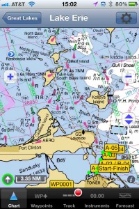
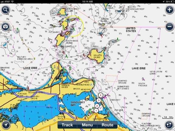
Garmin Bluechart Mobile app screenshot from iPad

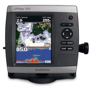
The Garmin BlueChart Mobile iOS app is now available for download from the App Store. This new app will allow your iPhone / iPad to function as a chartplotter using Garmin BlueChart maps. The app is free, while charts are available as an in-app purchase. read more

New Garmin chartplotters announced

Garmin GPSMAP 741xs

New Garmin GPSMAP 741xs chartplotter

Garmin has announced new models in their marine line of chartplotters and combination chartplotter/sounders. Features and capabilities have been upgraded and enhanced at many different levels.

read more

Garmin GPSMAP 541s review

Garmin GPSMAP 541s marine chartplotter review

Hands on with the Garmin GPSMAP 541s

The Garmin GPSMAP 541s Chartplotter is an incremental upgrade to the discontinued GPSMAP 540s.  The GPSMAP 541s has a 5″ diagonal color screen and the same Garmin appearance is maintained with the silver bars at the top and bottom of the case.  The major upgrade is the ability to interface with NMEA 2000 networks for engine diagnostics, weather instruments and additional uses.  The GPSMAP 541s comes pre-loaded with United States Coastal Charts and also has a SD card slot for additional charts.  The SD card can also be used for transferring waypoints, routes and tracks.  The GPSMAP 541s includes a built in sounder module, that allows direct connection to a transducer for depth and fish finder functions. read more

Garmin GPSMAP 78

Garmin GPSMAP 78 review

The Garmin GPSMAP 78 brought a major update to the GPSMAP 76 handheld line. Garmin had a huge hit with the 60/76 series, and instead of messing with a winner, they turned their attention to new interfaces, which were introduced on the Colorado series, followed by the touch screen Oregon line. These new units brought the ability to add custom maps and aerial imagery, paperless geocaching, and high-resolution screens, but the latter made them less than bright (although later models like the Oregon 450 have largely solved this problem).

read more

iNavX Marine Navigation for iOS review

iNavX for iOS review

Hands on Review of iNavX Marine Navigation for iOS

The iNavX marine charting app is targeted for recreational boaters.  This app allows navigation using NOAA raster charts and a few other proprietary vector and raster chart formats.  Users can create waypoints & routes and also record tracks.   read more

Magellan eXplorist 510 Marine Edition announced

Looks like Magellan is trying to carve out a new niche with boaters. Following Monday’s announcement of two Angler editions of the eXplorist line, they’ve now announced the Magellan eXplorist 510 Marine Edition, which includes U.S. coastal coverage up to two miles offshore, with data on 5-foot contours, tides, currents, wrecks, port plans, marsh areas, and marine services. And just in case you spend time both offshore and on inland waters, 12,000 US lakes are charted for you too.

read more

Navionics Marine & Lakes for iOS review

Hands on review of Navionics Marine & Lakes: US & Canada HD

The Navionics Marine Charting app is targeted for recreational boaters.  This app allows viewing the proprietary Navionics Nautical Vector Charts on your favorite iOS device.  Users can create routes and record tracks, which can be shared with friends using Facebook, Twitter, and email.  The routes can also can be uploaded to certain fixed mount chart plotters that might be found on a boat.  The Navionics app will function as a chart plotter displaying your position on the chart with the enabled route making it somewhat practical to use as a chart plotter while underway. read more

Garmin GPSMAP 78s review

GPSMAP78s_review

Hands on with the Garmin GPSMAP 78s

The Garmin GPSMAP 78s brings the first major update to the GPSMAP handheld line in over four years. The reason for it taking so long is that Garmin had a huge hit with the 60/76 series, and instead of messing with a winner, they turned their attention to new interfaces, which were introduced on the Colorado series, followed by the touch screen Oregon line. These new units brought the ability to add custom maps and aerial imagery, paperless geocaching, and high-resolution screens, but the latter made them less than bright (although the latest model, the Oregon 450, has largely solved this problem).

But patience has its rewards and Garmin did well not to rush things. With the 78 (and the forthcoming 62 series, which shares the same interface), Garmin has married the best features of the 60/76 models, with many of the advantages of the Oregon line. Before we get into the details, lets look at some closely…

read more

Garmin GPSMAP 78, 78s and 78sc marine handhelds

Garmin-GPSMAP-78sc

UPDATE 2: I’ve now posted my hands on review of the Garmin GPSMAP 78s. I’ve also got a resource/review page up for the GPSMAP 78.

UPDATE I’m now doing hands on testing of the GPSMAP 78 series, which seems to be the same platform as the forthcoming 62 series.

Garmin has announced three new color marine handhelds this morning, the GPSMAP 78, 78s and 78sc. Updating the 76 series, these units support Garmin custom maps and BirdsEye imagery. The “s” models include user profiles, a tri-axial compass and wireless exchange of data between units. The flagship 78sc includes pre-loaded cartography for the coastal US. And like the 76 series, they float!

There have been rumors of an updated 60 series, but I had doubts due to the supposed 62 series numbering. That is certainly making more sense after today’s announcement. We should know soon.

Manufacturer’s suggested retail price for the GPSMAP 78 series is $299.99, $399.99 and $499.99, with all three units expected to be available in May, 2010.

EDIT:

The Garmin product pages are showing prices $50 less more (oops!) than stated above and in the news release. Somebody goofed one place or the other. They also confirm paperless geocaching capability. Here are the links:

read more

Garmin GPSMAP 76

Garmin-GPSMAP-76-review The Garmin GPSMAP 76 is probably Garmin’s most popular entry-level marine handheld. This greyscale unit floats and can accommodate up to 8MB of added maps. Its pre-loaded basemap brings marine navigation aids, including lights, buoys, sound signals and day beacons.

Here’s a tool to compare the GPSMAP 76 to other Garmin marine handhelds.

read more