 Late last week I received an email from National Geographic Maps, informing me that their Topo.com website would be discontinued in 30 days, as they transtion to a new partnership with AllTrails.com. The National Geographic Topo
 desktop software will continue to work, although it is unclear if new updates will be forthcoming or not. This appears to primarily affect Magellan Triton users who have purchased Topo SuperQuads. If that’s you, you should read the info below and save those files to your hard drive over the next few weeks. read more
Archives for January 2012
Topo.com goes away, takes SuperQuads with it
January 30, 2012 By 18 Comments
RIP Geomate.jr
January 26, 2012 By 6 Comments
 UPDATE: As of February 9, they have revived the update zone, at least temporarily.
Sad news today for geocachers on a budget – the Geomate.jr will no longer be sold and the Update Zone service has been discontinued. Keep reading for all the gory details along with how to get a new pocket query into your Geomate…
Garmin StreetPIlot onDemand goes social
January 25, 2012 By Leave a Comment
 Garmin is rolling out several new features for its StreetPilot onDemand app for iOS, including Facebook and foursquare check-in, a Wikipedia layer, and the ability to add new voices and custom vehicle icons. Also new is an update to the Garmin Tracker iOS app for the GTU-10, allowing continuous tracking and the option to share a link so others can view the location as well. And in case the new features have piqued your interest, Garmin’s StreetPilot onDemand and Navigon apps will be on sale for $10 off during Macworld (January 26-28):
- Garmin StreetPilot Onboard USA: $39.99 instead of $49.99
- Garmin StreetPilot Onboard North America: $49.99 instead of $59.99
- Garmin StreetPilot onDemand: the annual subscription is $19.99 instead of $29.99
- NAVIGON USA: $39.99 instead of $49.99
- NAVIGON North America: $49.99 instead of $59.99
- NAVIGON MyRegion: $19.99 instead of $29.99
Handheld GPS 201: Mapping software
January 24, 2012 By 27 Comments

With today’s topic, I’m starting a new series, a follow up to my Handheld GPS 101 posts. Are you ready to move on to the next class? Alright then. Today’s topic is mapping software — and I’m not talking about maps for your GPS here, but rather desktop or laptop software that will turn you into a power user. read more
Supreme Court rules against warrantless GPS tracking
January 23, 2012 By Leave a Comment

The US Supreme Court did right by the fourth amendment today, ruling that GPS tracking requires a search warrant. In a 9-0 decision, the justices ruled against the Obama administration in the case of the US vs. Jones. Nevertheless, four justices differed on the broader issue of such tracking… read more
What to do about GPS reception problems
January 17, 2012 By 22 Comments
 Is your GPS not locking onto satellites? There’s usually a simple solution that works for both auto and handheld GPS units, but first, let’s look at why this is happening.
GPS news shorts from CES 2012
January 12, 2012 By 2 Comments
![]() I’ve posted a steady stream of news for several days now from the Consumer Electronics Show. But there’s also been a lot of other GPS news coming out of Vegas, so here are some shorter blurbs that didn’t get their own post, along with some related items and updates on things I’ve already posted.
I’ve posted a steady stream of news for several days now from the Consumer Electronics Show. But there’s also been a lot of other GPS news coming out of Vegas, so here are some shorter blurbs that didn’t get their own post, along with some related items and updates on things I’ve already posted.
Details emerge on Garmin Smartphone Link app
January 11, 2012 By 36 Comments
![]() Garmin has posted some FAQs on their Android Smartphone Link app, and we’ve got the highlights for you…
Garmin has posted some FAQs on their Android Smartphone Link app, and we’ve got the highlights for you…
- While the NAVTEQ traffic data may be the same as what you already receive, since you are getting it via your phone instead of over FM, you may expand your coverage area (many smaller metros have traffic coverage, but no FM-TMC reception)
- Find where traffic cameras are currently available
- Is it coming to the iPhone? Maybe
- Basic (free) weather gets you “current localized weather, temperature and forecasts,” while Advanced Weather adds “severe weather alerts, notifications of weather along your current route, and animated radar images on your Garmin navigator” (see image below)
- Garmin estimates “an average monthly data usage of around 2 MB per month…very heavy users might use up to 20 MB per month”
- But they also say that “an unlimited data plan is recommended when using the premium services available through Garmin Live Services”
TomTom segments lineup; brings Start to North America
January 10, 2012 By 6 Comments
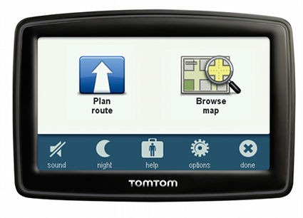 UPDATE: Read my hands-on review of the TomTom Start 55TM.
TomTom has announced a new product line-up for North America, breaking things down into entry-level (TomTom Start series, pictured above), mid-range (VIA series) and high-end (GO LIVE). This is the first time the Start will be offered in the US, although a model similar to the European Start, called the TomTom EASE, was introduced on this side of the pond a couple of years ago.
Magellan eXplorist 110 announced
January 9, 2012 By Leave a Comment
 Magellan has quietly rolled out a new entry level handheld, the eXplorist 110. The 110 appears very similar to the eXplorist 310 we reviewed last year, except that the new model doesn’t allow you to load additional maps and has no expandable memory. Still, with that great preloaded world map found on the new Magellan handhelds, that’s not a huge drawback.
