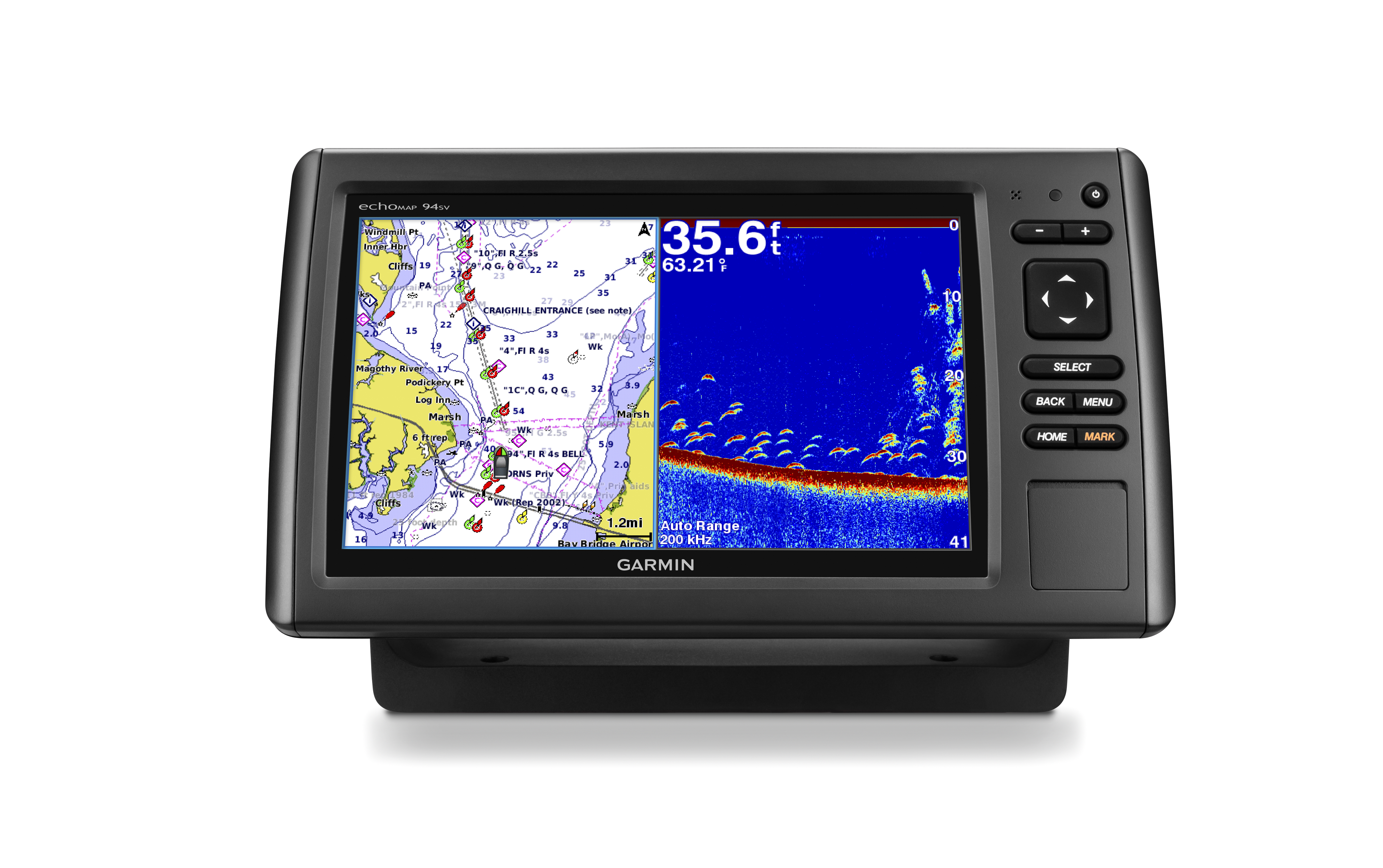
Garmin has finally released information on the next generation in the popular ecoMAP series for mariners of all types. The newest iteration of ecoMAP chartplotters will include scanning sonar capabilities without the need to purchase additional devices or mess with complicated hookups. The series will come in 4, 5, 7 and 9 inch color displays and is expected to be released in the first quarter of 2015. read more
Garmin Announces New ecoMAP Series
October 29, 2014 By 1 Comment
Garmin Opens Wearable Platform
September 24, 2014 By Leave a Comment

Garmin announced today that they are launching the new Connect IQ, the first open platform that will allow third-party developers to create apps for Garmin wearable products. I suspect this is an effort to compete with the recent launch of several different smartwatches, nearly all of which boast GPS capabilities. read more
Garmin nuvi 50LM Still Going Strong
September 5, 2014 By Leave a Comment
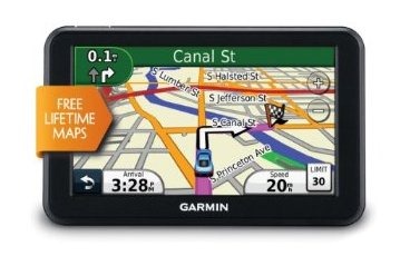
The Garmin nuvi 50LM was released in 2011 and is still one of the best entry-level GPS units available. In fact, if you do a quick search on Amazon or Google, you’ll find that it’s one of the most searched GPS units. Currently, the Garmin nuvi 50LM is ranked #96 on Amazon’s top 100 electronics. That’s 96 out of all of the electronics that Amazon sells, and it is three years old! With as fast as technology moves, that’s quite a testament to the quality of this unit. Check out our extensive hands-on review of nuvi 50LM for a preview of what to expect. read more
Garmin Second Quarter Report Overview
July 31, 2014 By Leave a Comment
![]()
Garmin released their second quarter financial report Wednesday morning before stocks opened. Overall, the report was still in the positive although the company’s shares fell as much as 7 percent in morning trading after the report was released. Garmin reported a total revenue of $778 million dollars this quarter and acknowledged the completed acquisition of Fusion Electronics to aid with their marine products. If you want to read the full report for yourself, you can download it here, but these are the parts I found most interesting: read more
Garmin Upgrade for GTN Provides Features, Better GPS
July 22, 2014 By Leave a Comment
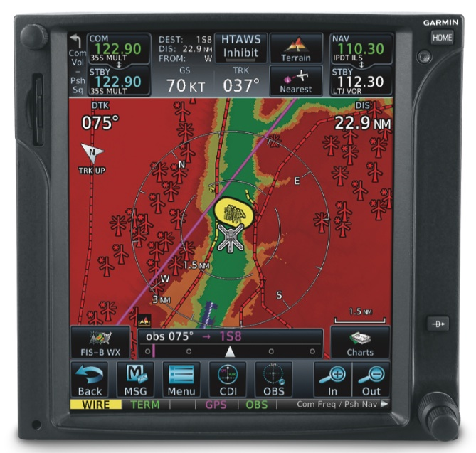 Garmin has announced an upgrade will provide additional features to their GTN touchscreen avionics. New features include Connext cockpit connectivity, which allows for wireless flight plan transfer between the TGN 750/650 series navigators and Garmin Pilot (which also recently received an upgrade). Connext will also provide better GPS position data and the option to display weather, traffic and altitude information. This upgrade will include database syncing capabilities, FastFind to make searches easier and more streamlined, airspace altitude overlay, WireAware to help avoid wires and more. read more
New Garmin Approach S6 Golf Watch does more than GPS
June 26, 2014 By Leave a Comment
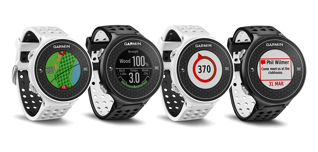
All golf watches provide GPS for on the green, helping avoid traps and get around doglegs, but the new Garmin Approach S6 Golf Watch strives to go even further. With innovative technology, the Approach S6 Golf Watch will measure your swing metrics and provide valuable training aids for getting it just right with SwingTempo, designed to help with backswing and downswings, SwingStrength, so you know how hard you hit the ball, and TempoTrainer to help golfers synchronize their swing mechanics and fine-tune their tempo. read more
Garmin GTU 10 live GPS tracker announced
January 4, 2011 By 2 Comments

UPDATE: Read my hands on review of the Garmin GTU 10.
Garmin has announced their entry into the GPS tracking market with the Garmin GTU 10 GPS locator and web-based Garmin Tracker™. The small (3”x1.3”x.8”), lightweight (1.7 oz.) and waterproof device can be used to track pets, kids, endurance racers, construction equipment – you name it.
MapSource Product Creator
June 16, 2010 By 10 Comments
 Ever had the itch to make your own maps? Wished that you had access to the same cartography tools used by Garmin? Well, your dreams may be coming true. A new MapSource Product Creator page on Garmin’s developer site offers you the opportunity to…
Create custom maps that can be easily loaded into Garmin devices with the MapSource Product Creator (MPC). The MPC can create everything from full country topographic maps to maps for specific industry, military or research applications.
Garmin Oregon 450 review
April 13, 2010 By 680 Comments

Hands on with the best Oregon yet
UPDATE: This model has been discontinued and replaced by the Oregon 600.
The Garmin Oregon 450 is one of the newest members of the touchscreen Oregon family, featuring the latest improvements such as better visibility, a tri-axial compass, custom dashboards, advanced track navigation features and the ability to load custom maps and BirdsEye aerial imagery. I’ll delve into those details shortly, but first I want to clarify the differences between the Oregon 450 and some closely…
Garmin BirdsEye aerial imagery now live
April 1, 2010 By 22 Comments
 Garmin barely met their March deadline for rolling out BirdsEye aerial imagery. It showed up late yesterday in the form of updates to their BaseCamp software and firmware updates for eligible units — the Colorado and Oregon series; there remains some question about whether both Dakota models are compatible – the Dakota 20 is for sure (more on that below).
EDIT: We’ve learned that Garmin decided not to support BirdsEye imagery on the Dakota 10, due to its lack of an expansion card slot.
To get started, run WebUpdater and download or update BaseCamp. Once you start BaseCamp and connect your unit, you should get a message asking if you want to create BirdsEye imagery for your device. You can download a low-resolution demo for free or pony up $29.99 for a year of downloads.
I’m posting a couple of images here. I haven’t used them out in the field yet, but they appear washed out on the screen of my Oregon 400t. The one at left is Panther Stadium in Charlotte; below is a high elevation bald in the Rocky Fork tract, a new 10,000 acre public land acquisition near the NC/TN border. The resolution available for that area does not allow me to pick out forest roads, limiting its usefulness. This is an early test though; other areas may have higher resolution imagery available. In more open terrain (e.g., western US), you might be able to pick out trails and 4WD tracks, even at this resolution.
