Sunday, March 18, 2012

NAIP aerial photography

Naip_aerial_photo_mendocino

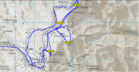
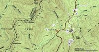
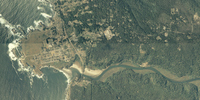
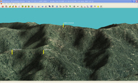
The Map Room recently covered the National Agricultural Imagery Program (NAIP). Now don’t be confused by the Agriculture part of the name, because the NAIP is of value to a much broader audience. NAIP offers very recent, natural-color aerial imagery of almost the entire U.S., at a relatively high resolution. Full county mosaics are $50. For my county, there is a 2006 image with a resolution of 2 meters/pixel, and a 2005 image at 1 meter/pixel. The image at left, of the Big River estuary and Mendocino, CA, is supposed to be 2 meter resolution. The resolution doesn’t look quite that sharp to me, but nevertheless, I can make out recent changes in logging roads in the area I frequent for mountain bike rides. The image to the right below, shows a 3-D view with waypoints, that I created using OziExplorer.
Ozi_3d_with

The color county mosaics are in MrSID format. You can use OziExplorer to work with these files, and the NAIP website lists several viewers. Quarter quadrangles are available in GeoTIFF format. Here’s the latest (2005) aerial photo coverage map for color county mosaics.

Unfortunately, we’re dealing with the feds here, so ordering is a pain and delivery is slow.

Free Garmin World Wide Basemap, Part II

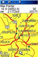
Following a comment today, and further investigation when I got home, I’m going to retract what I said about the free Garmin World Wide Basemap, at least for the 60CSx. The transfer to my unit appears to have not worked, and I now believe that what I am seeing on the screen is nothing more than the 60CSx’s built-in Americas autoroute basemap.

I have no reason to believe that it would not work in a nuvi, and I have to wonder if it wouldn’t work for any Garmin mapping GPS, if you ran it through MapSource, which requires significant effort. We’re talking registry hacks or the use of GPS Map Manager as described in my book.

On the bright side, my existing basemap does seem to be intact! My apologies if I got your hopes up for something both free AND easy.

read more

Free Garmin World-Wide Basemap

World_wide_base_map_1UPDATE: Before you get too excited, read this.

As if my recent posts dissing the nuvi weren’t enough to earn me the enmity of Garmin, now I go and post this. I’ll never get a review unit now!

I saw this thread in the GpsPasSion nuvi forum the other day, showing how to get a World-Wide Garmin basemap for free. Now this isn’t from some file-sharing site; nope, this is straight from Garmin themselves. The page is actually set up to download the Garmin World Wide Basemap for iQue 3600 owners, but I beleive it will work for any Garmin GPS that can accomodate maps. I was able to easily get it on my 60CSx.

Okay, before you go off and download it, here are a few caveats:

  • Read the full thread at GpsPasSion before doing anything.
  • I’m not guaranteeing anything here. You could erase your existing basemap. You may want to change the name of this one before transferring it to your GPS, but I’m not sure that will prevent erasure of the original. (Should have tried that myself!)
  • This is version 3.01, and it bears a date of April 7, 2004.
  • It does not appear to be the same product as Garmin’s WorldMap product, which has more detail, at least in some areas. But as you can see in the screen capture, it ain’t bad.

read more

GPS Maps of Mexico

50k_scale_mexican_map

GPS Information.net has some excellent new pages up on various GPS maps of Mexico. They include a great page on DRG’s that can be used with OziExplorer. A 1:50,000 scale topo map image from that page is shown at left. They also show examples of Baja Expeditioner maps, which are compatible with Garmin GPS units. Finally, the articles also compare BiciMapas Mexico Atlas maps with Garmin City Select Mexico NT maps (available from Amazon and GPSNow.com).

Related post:


Topograhic maps in Google Earth

Finally! You can now easily view topo maps in Google Earth, courtesy of the Global Biodiversity Information Council. And not just for the U.S.; Canada, Australia and New Zealand are also included. Be sure you note the listed caveats:

The topographic map layers provide increasingly detailed information as the Google Earth client is zoomed in. It is best not to activate the layers until the client is zoomed close to the area of interest.

  • Some topographic layers will spawn an error when zoomed too far out.
  • Similarily some topographic layers will spawn an error when zoomed too far in.
  • Occasionally errors will occur if the remote server takes too long to respond.
  • It is best to turn off the topographic layers when closing down Google Earth. This will prevent errors being reported when Google Earth is restarted.

Now it’s not the smoothest or clearest way to view topos, but it’s a start. These tools will only get better.

Many, many thanks to Stefan at Ogle Earth for finding this one.

Technorati tags: Google Earth, maps, topo

1:50,000 scale topo maps of China

Cartography reports today that the entirety of China has been mapped at a scale of 1:50,000. All land areas were mapped; datasets include elevation, imagery, terrain, hydrology, transportation, boundaries,  and geographic names. The database also delineates farmland, forest land, grassland, residential areas, and industrial land. One meter aerial imagery covers large and medium sized cities. From the People’s Daily Online report…

"Li Weisen, told the press conference that as supervisor of surveying and mapping, the bureau will try its best to make the database available to all while taking security into consideration."

read more

Using GIS Data with GPS

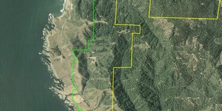
Aerial photo with GIS boundary filesThere is a wealth of Geographic Information System (GIS) data available on the web — everything from public land boundaries to international contour files. It is amazing what you can find. A few examples:

  • I live in an area dominated by private timber lands. I found private timber company boundary files offered through this website.
  • Looking around for public land boundary files, I discovered that the California Department of Fish and Game owns a series of ecological reserves. Not only did I learn about this little known treasure, I found boundary files as well.
  • I was fortunate to be able to visit Ecuador a year ago. I used files from the GIS Data Depot to create a contour map of the country, that I was able to load onto my GPS receiver. I was able to find other sources showing roads, streams, cities, provincial boundaries and major volcanoes

GIS files are most commonly found in either .shp (shapefiles) or .e00 formats. Unfortunately, few consumer-level GPS mapping programs allow you to utilize GIS files.  OziExplorer is my favorite program for working with GIS files. Using it, you can convert these files to tracks and points, and even display this info on your GPS. Another program, ArcExplorer, is a free GIS viewer, but it lacks GPS compatibility. The image, to the right above, was captured from OziExplorer. It shows public land boundaries in green and private timberlands in yellow, superimposed on a color aerial photo.

read more

U.S. High Points

Us_high_points

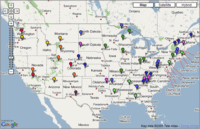
Here is a nice Google Maps "mashup" for you outdoor enthusiasts — the U.S. Highpoint Explorer. It allows you to view the highest point in each of the 50 states, and it also allows you to view county high points within a state. There is even a regional view that shows the high points in the current view. A sidebar gives the key stats — name, elevation and rank. Pretty cool tool for you peak baggers! Via

GPS Maps for Mexico

Cabo_san_lucas

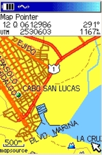
The holidays are over, winter is here, and many of us are dreaming of vacations in warmer climes. I’ve been asked a few times about maps for Mexico, and I was reminded recently of a website that offers a great deal of resources for the GPS enthusiast headed south of the border. So it seemed an appropriate time to call your attention to BiciMapas.

Although the stated focus is maps for mountain biking, there’s a lot more to the site than that. They have highway maps and digital raster graphics (DRG’s) that can be used in programs like OziExplorer. It seems like the most common format for their GPS maps is Garmin, but some maps are also available for Magellan receivers. And if Alberto Najera, the man behind BiciMapas, has his way, I’ll bet that you’ll see Lowrance maps from him before long.

Other than BiciMapas, your choices are limited. You could get the Garmin World Map or the Magellan Worldwide Basemap. But even Garmin says that such a low-level of detail product "is generally recommended only if no other coverage is available for the area."

read more

What kind of maps can I put on my GPS (and what do you mean by raster and vector)?

I received a PM from the Adirondack Forum today that said:

"…I just bought the Garmin 60CS. I have a question about the maps. Do I need the Garmin Mapsource United States Topo or… the one from National Geographics Topo that I think is better for hiking? If I don’t buy the Garmin Mapsource Topo, can I download maps in my GPS?…"Raster_image

This question comes up so often that I felt obligated to post an answer here. The answer is no, you cannot load National Geographic TOPO! maps onto any GPS. You can however, create waypoints and routes with TOPO!, and transfer these to your GPS, but not the maps. Let’s look at why not, and what kind of maps you can load onto your GPS.

The National Geographic TOPO! maps look just like a paper map from USGS (example above, at right). That’s because they are scanned images, also known as raster imagery. Since they are scans, they have a pretty big file size. That’s why it takes 10 CDs to cover the state of California. And that’s one of the main reasons that GPS manufacturers have taken a different approach.

read more