Sunday, March 18, 2012

Archives for 2006

GPS for golfers

UPDATE: Read my Garmin Approach G5 review and my GolfLogix 2008 review

It seems like GPS is everywhere these days, and the golf course is no exception. There are two main types of golf GPS systems. One is owned by the course and integrated into your cart. The other is a handheld unit that golfers can carry along, no matter what course you play. Here are the four popular forms of the latter type (product descriptions are adapted from the manufacturer and / or Amazon):
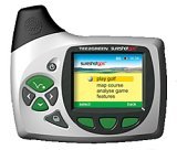
  • SureShot GPS (pictured at right) – The SureShot GPS is a compact, hand-held, easy to use GPS device specific to golf. With the option of attaching to your belt or golf cart, the SureShotGPS means never having to look for a distance again. Wherever in the world you play golf, the SureShot GPS will allow you to obtain distances from tee to green. Experience the difference with better club selection, speedier play and statistical information per round. There are thousands of courses available, and if by chance your’s is not, it can be mapped for you within a few days. Official SureShot GPS web page.

read more

GPS for hikers

Hikers_with_gps_hiking

Last updated December 3, 2009

When selecting a GPS for hiking, two key criteria come to mind. It’s likely that a hiker will want a unit that’s good for navigation, and will not want to have to hold it out at arm’s length for the entire hike, which means that…

Reception is important for hikers

I recommend a unit that will get great satellite reception, so I’m going to limit my recommendations to models with a high sensitivity chipset, such as the SiRFstar III or MediaTek chipset. With these receivers, you can stick them in your pocket, or a mesh pocket on a day pack, and you are still likely to have adequate reception. Some of this is dependent upon how the satellite constellation is configured for your location on any given day, but overall, I think you’ll be happy with the performance of these units.

read more

GPS for cyclists

Last updated October 29, 2009

Whether you are a road biker or a mountain biker, there’€™s a GPS that will work well for you, and it can mount right on your handlebars. Either type of cyclist will have special needs, so let’€™s take a look at your options:

GPS for road bikersGarmin_edge_705

GPS Cyclometers

The Garmin Edge series is comprised of cyclometer-type GPS receivers. All of them have high-sensitivity chipsets for superior satellite reception in urban canyons and under canopy. While they are excellent cyclometers, they aren’€™t all that great as navigation devices (more on navigation options below). If you are primarily wanting to track your performance though, the Edge series is an excellent choice.

The newest models are the Garmin Edge 605 and Edge 705, which add color screens and mapping capability (maps purchased separately) to the features found on previous models. The 705 adds a heart rate monitor, barometric altimeter
and the ability to share data wirelessly with another Edge 705. The 705 is also compatible with an optional cadence sensor and power meter. For a detailed look at the new Edge models, be sure to check out my hands-on review of the Edge 605.

Edge_305_hr

The first-generation Garmin Edge 205 and Garmin Edge 305 (pictured at left) have a monochrome display and lack the mapping capabilities of the 605 and 705. The 305 will give you more accurate data on elevation gain than the 205, thanks to its barometric altimeter.

The Edge 305 actually comes in three models;€” the 305CAD includes a cadence/speed sensor, the 305HR includes a heart rate monitor, and the Edge 305HR+ comes with both.

read more

Over 50,000 free maps

Free_the_maps
Late this past summer, Jared Benedict posted a ransom note for maps. But he wasn’t holding them hostage; on the contrary, his goal was map liberation. And now he has succeeded. The Libre Map Project  has posted over 50,000 free USGS topo maps.

I’ve been following this for awhile, and last weekend, all the maps  were finally made available. These are 1:24,000 scale, 7.5′ digital raster graphic (DRG) quadrangles. I’ve posted before about free USGS topographic quad maps, and about OziExplorer, my favorite mapping software that allows you to use DRG’s with (but not on) your GPS. Here is a good resource on importing DRG’s into OziExplorer.

Related post:


GPS for runners

garmin-forerunner-405cx

Last updated November 11, 2009

A GPS receiver lets runners track their athletic performance — not only how far you run, but heart rate, elevation gain, and more. And it gives you an easy way to maintain a record of your data; just download it to your computer. The units below are less than ideal for navigation, but they are great for capturing your running stats. Here’s a run down (pardon the pun) on a few key models:

Garmin Forerunner 405Cx

The newest model, the Forerunner 405Cx (shown at right), increases accuracy in heart rate-based calorie computation and comes with two additional form-fitting bands to accommodate large or small wrists.

Garmin Forerunner 310XT

Another new entry, the Garmin Forerunner 310XT is targeted to tri-athletes. It is waterproof to 50 meters and can go for up to 20 hours on one charge.

Garmin Forerunner 405

The Forerunner 405 builds on the feature set found in previous models. Available in either sage green or black, the unit has a sleeker and more watch-like appearance. A wireless connection sends data to your computer, eliminating the need for cables. The perimeter of the unit features a touch-sensitive bezel, minimizing the need for buttons on the unit.

Forerunner_305_1Garmin Forerunner 205 and 305

The  Forerunner 205  and Forerunner 305 have greatly improved reception (compared to the first generation models below), and are ideal for trail runners or anyone with a restricted view of the sky. The 305 (pictured at left) ups the ante, adding a heart-rate monitor.


Garmin Forerunner 101, 201 and 301

These last generation products don’t have the killer reception and updated styling of the later models, but they will do just fine for someone running in the open. The Forerunner 101 doesn’t allow transfer of your running data to the computer, and uses two AAA batteries. The Forerunner 201 does allow data transfer, and drops the weight to 2.75 ounces thanks to the li-ion battery. The Forerunner 301 adds a heart rate monitor to this feature set.

read more

Satellite imagery and aerial photos on your GPS

Iway600csat_large
Earlier this week, Lowrance announced a new GPS receiver, the iWAY 600C. What makes this unit so special is that it can display satellite imagery. It looks like they will beat DeLorme, manufacturers of the fabled Earthmate PN-20, to the punch (though no release date has been set). Actually, Garmin already has marine units that can accommodate aerial photography.

This is a rare feature, and one reason is memory. The points and lines you see on your GPS screen come from data files, not images. It takes a lot more room to store the latter. 25 GB of the iWAYs’s 30 GB hard drive is devoted to maps and satellite imagery. But hey, if they can make an 80 GB iPod, this stuff can’t be to far away for GPS. Hopefully, the manufacturers will get it right, and not charge us extra for imagery that is available for free on line.

Get the Lowrance iWAY 600C at Amazon.

read more

GPS data search tool

Google recently announced their custom search engine tool. I didn’t really see how I would use it at first; then I thought about creating a search engine designed to go after GPS data. After all, I find myself searching for it often for trip planning. So give it a try, perhaps with the name of a popular trail or a geographical area: 


Search for waypoints, tracks, POI’s, maps and aerial imagery

I’ve included over 30 sources so far, including National Geographic TOPO!’s MapXchange, the TOPO USA file exchange, MotionBased, several points of interest (POIs) sites, a great U.S. DRG resource, sites with free Garmin maps, aerial photos, and more. I’ve tried to keep out sites that charge for data, or sites that will return massive numbers of duplicate or irrelevant results. Oh, and if you find yourself dealing with data types that your software won’t handle, check out a GPS file converter.

read more

Best GPS for pedestrians

This article in theday.com covers a lot of ground, focusing mainly on GPS for pedestrians, with a strong emphasis on the Garmin nuvi and its competitors. Here’s the most informative snippet from the piece, comparing Garmin, TomTom and Magellan for those on foot:

"…some devices are more helpful than others for walkers. Garmin says its pedestrian mode negates one-way roads so that walkers can be directed the wrong way. It also allows walkers to go through access roads in parks where cars aren’t allowed.

Similarly, TomTom International BV’s new entry-level $499 TomTom ONE device, 5.5 ounces lighter than TomTom’s next-smallest device, directs walkers in pedestrian mode down the wrong way on one-way streets or along pedestrian bridges or bike paths if those are the fastest routes. And the pedestrian modes on many cellphone services such as Sprint’s MapQuest Navigator enable users to find walking directions and eliminate restrictions such as one-way streets and right-turn-only intersections.

But on the Magellan devices, walkers using the street maps will be directed as if they were a car. Magellan expects pedestrian routing features to be available on its new products early next year."

Related posts:

read more

Bluetooth and GPS for hands-free cell phone use

C550_bluetooth_screen
Bluetooth is one of the hottest new features in GPS receivers, primarily because you can use them for hands-free cell phone calls, via the GPS receiver’s built-in microphone and speakers. Yet this technology can do so much more.

Address book syncing allows you to look up and dial numbers from your personalized phone book or your phone’s call history log. Plus, you can look up points of interest (POI’s), find a restaurant and have your GPS call to make a reservation!

Each of the units listed below offer Bluetooth for hands-free cellphone use. Except where noted the links go to our own auto GPS reviews:

read more

Discriminav – The world’s first racist GPS

Check out this video promoting the Discriminav, billed as the world’s first fully racist GPS navigation system.

Via Digg. My apologies in advance to all who are offended.